
Pretoria or Tshwane is one of South Africa’s three capital cities, serving as the seat of the executive branch of government, and as the host to all foreign embassies to South Africa. Cape Town is the legislative capital whereas Bloemfontein is the judicial capital.

The population of South Africa is about 60.1 million people of diverse origins, cultures, languages, and religions. The 2011 South African census was the most recent held; the next will be in 2022.

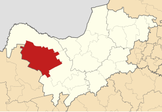
North West is a province of South Africa. Its capital is Mahikeng. The province is located to the west of the major population centre of Gauteng.

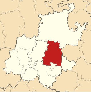
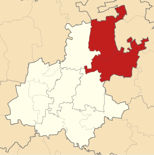
The City of Tshwane Metropolitan Municipality is the metropolitan municipality that forms the local government of northern Gauteng Province, South Africa. The Metropolitan area is centred on the city of Pretoria with surrounding towns and localities included in the local government area.

Bronkhorstspruit is a town 50 km east of Pretoria, Gauteng, South Africa along the N4 highway towards Witbank. It also includes three townships called Zithobeni, Rethabiseng and Ekangala. On 18 May 2011, the Tshwane Metropolitan Municipality took over the municipal administration from the abolished Kungwini Local Municipality, which makes Bronkhorstspruit part of Tshwane.

The Overberg District Municipality is a district municipality that governs the Overberg region in the Western Cape province of South Africa. It is divided into four local municipalities and includes the major towns of Grabouw, Caledon, Hermanus, Bredasdorp and Swellendam. The municipal area covers 12,241 square kilometres (4,726 sq mi) and had in 2007 an estimated population of 212,787 people in 60,056 households.
The City of Ekurhuleni Metropolitan Municipality is a metropolitan municipality that forms the local government of the East Rand region of Johannesburg, Gauteng. The municipality itself is a large suburban region east of Johannesburg. The name Ekurhuleni means place of peace in XiTsonga. Ekurhuleni is one of the five districts of Gauteng province and one of the eight metropolitan municipalities of South Africa. The seat of Ekurhuleni is Germiston. OR Tambo International Airport falls in the Kempton Park area of Ekurhuleni.

The nine provinces of South Africa are divided into 52 districts, which are either metropolitan or district municipalities. They are the second level of administrative division, below the provinces and above the local municipalities.

iLembe is one of the 11 district municipalities of KwaZulu-Natal province in South Africa. The seat of iLembe is KwaDukuza. The majority (82%) of its 606,809 people speak Zulu as their first language. The district code is DC29. It was formerly named the King Shaka District Municipality.

Motheo was, until the municipal elections of 18 May 2011, a district of the Free State province of South Africa. At the time of the 2011 elections it was disestablished as a consequence of Mangaung Local Municipality being upgraded to a metropolitan municipality
Metsweding District Municipality was, from 2000 till 18 May 2011, a district municipality in Gauteng province, South Africa. Metsweding, and its component local municipalities, was disestablished and absorbed into the Tshwane Metropolitan Municipality on the date of the 2011 municipal election.

Alfred Nzo is one of the 6 districts of Eastern Cape province of South Africa. The seat of Alfred Nzo is Mount Ayliff. The majority of its 801 344 people speak Xhosa. The district code is DC44.

Dr Kenneth Kaunda District Municipality is one of the 4 districts of North West province of South Africa. The seat of Kaunda District is Klerksdorp. A plurality of its 742 821 people speak Setswana. The majority of its people live in the City of Matlosana Municipality. The district code is DC40. The district was formerly known as the Southern District Municipality. It is named after Kenneth Kaunda, the first President of Zambia.

Waterberg is one of the 5 districts of Limpopo province of South Africa. The seat of Waterberg is Modimolle. The majority of its 745 758 people speak Sepedi, also known as Northern Sotho. The district code is DC36.

The Polokwane Local Municipality is a local municipality located within the Capricorn District in the Limpopo Province of South Africa. It shares its name with the city of Polokwane.
Bushbuckridge Local Municipality(Mapulaneng) is a third-level administrative division in the Ehlanzeni District of Mpumalanga in South Africa. Commercial farming, which consists of pine /bluegum plantations, tobacco, cotton, sub-tropical fruits and vegetables is practised in the municipality's countryside. The municipality includes the southern part of the Kruger National Park. Bushbuckridge is the largest local municipality in Mpumalanga, both in terms of land size and population figures.

Nokeng tsa Taemane Local Municipality was a local municipality in the Metsweding District of Gauteng in South Africa.
Kagisano Local Municipality was a local municipality in Dr Ruth Segomotsi Mompati District Municipality, North West Province, South Africa, until the election of 18 May 2011, when it was merged with the Molopo Local Municipality to form the Kagisano-Molopo Local Municipality.

Molopo Local Municipality was a local municipality in Dr Ruth Segomotsi Mompati District Municipality, North West Province, South Africa, until the election of 18 May 2011, when it was merged with the Kagisano Local Municipality to form the Kagisano-Molopo Local Municipality.

