The Province of the Cape of Good Hope, commonly referred to as the Cape Province and colloquially as The Cape, was a province in the Union of South Africa and subsequently the Republic of South Africa. It encompassed the old Cape Colony, as well as Walvis Bay, and had Cape Town as its capital. In 1994, the Cape Province was divided into the new Eastern Cape, Northern Cape and Western Cape provinces, along with part of the North West.

The Karoo is a semi-desert natural region of South Africa. No exact definition of what constitutes the Karoo is available, so its extent is also not precisely defined. The Karoo is partly defined by its topography, geology and climate, and above all, its low rainfall, arid air, cloudless skies, and extremes of heat and cold. The Karoo also hosted a well-preserved ecosystem hundreds of million years ago which is now represented by many fossils.

Oudtshoorn Municipality is a local municipality within the Garden Route District Municipality, in the Western Cape province of South Africa. As of 2011, the population was 95,933.

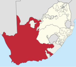
Kannaland Municipality is a local municipality located within the Garden Route District Municipality, in the Western Cape province of South Africa. The municipal area is situated in the western part of the Little Karoo and includes the towns of Ladismith, Calitzdorp and Zoar. As of 2011, it has a population of 24,767. Its municipality code is WC041.
Route 62 is a tourist route in South Africa that meanders between Cape Town, Oudtshoorn, the Garden Route, and Gqeberha, offering the scenic alternative to the N2 highway. Route 62 is named for the R62 provincial route, which it follows from Montagu to Humansdorp, but the tourist route extends further along other highways to Cape Town and Gqeberha.

The Swartberg mountains are a mountain range in the Western Cape province of South Africa. It is composed of two main mountain chains running roughly east–west along the northern edge of the semi-arid Little Karoo. To the north of the range lies the other large semi-arid area in South Africa, the Great Karoo. Most of the Swartberg Mountains are above 2000 m high, making them the tallest mountains in the Western Cape. It is also one of the longest, spanning some 230 km from south of Laingsburg in the west to between Willowmore and Uniondale in the east. Geologically, these mountains are part of the Cape Fold Belt.
The magistrates' courts are the lowest level of the court system in South Africa. They are the courts of first instance for most criminal cases except for the most serious crimes, and for civil cases where the value of the claim is below a fixed monetary limit.

The N12 is a national route in South Africa which runs from George through Beaufort West, Kimberley, Klerksdorp and Johannesburg to eMalahleni.

John Hutchinson, OBE, FRS was an English botanist, taxonomist and author.

De Rust is a small village at the gateway to the Klein Karoo, South Africa. The name is Dutch and literally translates to "The Rest", referring to the town's original purpose of being a resting place for settlers en route through the challenging terrain of a nearby Swartberg gorge.
Johann Fran(t)z Drège, commonly referred to by his standard botanical author abbreviation Drège, was a German horticulturalist, botanical collector and explorer of Huguenot descent.

The R62 is a provincial route in South Africa that connects Ashton with Humansdorp. The R62 runs through the Little Karoo and the Langkloof, passing through Montagu, Ladismith, Calitzdorp, Oudtshoorn, and Joubertina.

Ladismith is a town and agricultural centre in the western Little Karoo region of South Africa's Western Cape province.
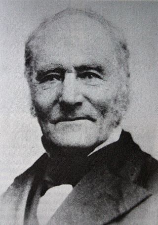
Thomas Charles John Bain was a South African road engineer. As a prolific road building pioneer, Bain was responsible for the planning and construction of more than 900 km of roads and mountain passes, many of them still in use today, over a career spanning from 1848 until 1888. These passes through the mountain ranges between the thin coastal plain and the interior of the former Cape Colony in South Africa, played a major role in opening up the vast hinterland of South Africa.

Touws River is a small railway town of 8,126 people in the Western Cape province of South Africa. It is located on the river of the same name, about 160 kilometres (100 mi) north-east of Cape Town. The Touwsrivier CPV Solar Project is located just outside of the town and supplies 50 MW to the national electrical grid.

The Cape Pioneer Trek is a 7-day South African mountain biking event through the Great and Little Karoo.

Herold is a hamlet in George Municipality in the Western Cape province of South Africa. It is located at the northern end of Montagu Pass, halfway between George (city) and Oudtshoorn. Herold and Herolds Bay were both named for Tobias Johannes Herold, the Dutch Reformed minister at George from 1812 to 1823. The N9 national road runs to the north of the hamlet.


