Cape Town is the legislative capital of South Africa. It is the country's oldest city and the seat of the Parliament of South Africa. It is the country's second-largest city, after Johannesburg, and the largest in the Western Cape. The city is part of the City of Cape Town metropolitan municipality.

The Great Dividing Range, also known as the East Australian Cordillera or the Eastern Highlands, is a cordillera system in eastern Australia consisting of an expansive collection of mountain ranges, plateaus and rolling hills. It runs roughly parallel to the east coast of Australia and forms the fifth-longest land-based mountain chain in the world, and the longest entirely within a single country. It is mainland Australia's most substantial topographic feature and serves as the definitive watershed for the river systems in eastern Australia, hence the name.

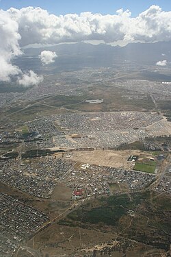
The Cape Flats is an expansive, low-lying, flat area situated to the southeast of the central business district of Cape Town. The Cape Flats is also the name of an administrative region of the City of Cape Town, which lies within the larger geographical area.

Strand is a seaside resort town in the Western Cape, South Africa. It forms part of the Eastern Suburbs of the City of Cape Town Metropolitan Municipality, situated on the north-eastern edge of False Bay and near the foot of the Helderberg Mountains. Its geographical position is between Somerset West and Gordon's Bay, and is about 50 km southeast of Cape Town City Bowl. Strand has a population of approximately 50,000. Strand's main attraction is the beach; 5 km of white sandy beach off False Bay.

.

Kuils River is a town in the Western Cape, South Africa, 25 km east of Cape Town CBD at the gateway of the Cape Winelands. It is also the name of the main tributary of the Eerste River, and forms part of the Eastern Suburbs zone of the City of Cape Town.

The City of Cape Town is a metropolitan municipality that forms the local government of Cape Town and surrounding areas. As of the 2016 community survey, it had a population of 4,005,016.

Mitchells Plain is a large township located within the City of Cape Town, Western Cape, South Africa and situated about 28 km (17 mi) from the Cape Town city centre. It is one of South Africa's largest residential areas and contains multiple smaller suburbs. It is located on the Cape Flats on the False Bay coast between Muizenberg and Khayelitsha. Conceived of as a "model suburb" by the apartheid government, it was built during the 1970s to provide housing for Coloured victims of forced removal due to the implementation of the Group Areas Act.

Brackenfell is a town in the Western Cape province of South Africa and a northern suburb of Cape Town, situated about 30 km north-east of the city.

Helderberg refers to a planning district of the City of Cape Town metropolitan municipality, the mountain after which it is named, a wine-producing area in the Western Cape province of South Africa, or a small census area in Somerset West.
Frank Martin is a former Democratic Alliance councillor for the 19th Ward in Cape Town which includes Blue Downs, Kuilsriver, Wesbank and a small eastern section of Delft.

Philippi is a large urban and semi-urban area in Cape Town's Cape Flats region, in the Western Cape, South Africa. It comprises the Philippi Horticultural Area to the west, and the neighbourhoods of Brown's Farm, Philippi East and Samora Machel located within its eastern half. The neighbourhoods of Gugulethu and Nyanga are located to its north. The horticultural area is sparsely populated compared to the surrounding city and contains many farms.

Rondebosch Common is an open common of about 40 hectares in Rondebosch, Cape Town in South Africa. A common is defined as "a piece of open land for public use, esp. in a village or town". It contains one of the few surviving pockets of the critically endangered “Cape Flats Sand Fynbos” vegetation type, which exists nowhere else in the world.
The Diep River Fynbos Corridor is a nature reserve located in the Blaauwberg region of Cape Town, South Africa. It forms part of the larger Table Bay Nature Reserve, which was established in June 2012.
Cape Flats Sand Fynbos (CFSF), previously known as Sand Plain Fynbos, is a critically endangered vegetation type that occurs only within the city of Cape Town. Less than 1% of this unique lowland fynbos vegetation is conserved.

Macassar Dunes Conservation Area is a 1,116-hectare (2,760-acre) coastal nature reserve in Macassar, within the City of Cape Town, South Africa.

Cape Lowland Freshwater Wetland is a critically endangered vegetation type of the Western Cape, South Africa.

The following outline is provided as an overview of and topical guide to Cape Town:
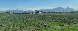
The Philippi Horticultural area is a large semi-rural area of Philippi on the Cape Flats region of Cape Town in the Western Cape province of South Africa. The horticultural area is sparsely populated compared to the surrounding city and contains many farms. The 2011 national census recorded 6,618 residents living in the area with an additional 2,961 residents living in the Knole Park community in the central western part of the area.