
Randburg is an area located in the Gauteng province of South Africa. Formerly a separate municipality, its administration devolved to the newly created City of Johannesburg Metropolitan Municipality, along with neighbouring Sandton and Roodepoort, in the late 1990s. During the transitional period of 1996–2000, Randburg was part of the Northern Metropolitan Local Council (MLC).
The N21 is a proposed national route in the City of Cape Town, South Africa. It is also known as the Peninsula Expressway ring road. Once complete, it will link the northern suburbs on the Atlantic seaboard with the southern suburbs on False Bay (Muizenberg). The R300 freeway is entirely part of the proposed route.

Rondebosch is one of the Southern Suburbs of Cape Town, South Africa. It is primarily a residential suburb, with shopping and business districts as well as the main campus of the University of Cape Town. The area is noted for its beautiful views of Table Mountain, its convent location to the rest of the city of Cape Town, and its proximity to the University of Cape Town.

Tokai, a large residential suburb of Cape Town, South Africa, is situated on the foothills of the Constantiaberg, and is bordered by Steenberg and Kirstenhof to the south, Bergvliet to the east, Constantia to the north and the SAFCOL pine tree plantations against the mountain to the west.
Muizenberg is a beach-side town in the Western Cape, South Africa. It is situated where the shore of the Cape Peninsula curves round to the east on the False Bay coast. It is considered to be the main surfing spot in Cape Town and is currently home to a surfing community, centered on the popular 'Surfer's Corner'.
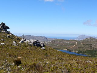
Silvermine Nature Reserve forms part of the Table Mountain National Park in Cape Town, South Africa. It covers the section of the Cape Peninsula mountain range from the Kalk Bay mountains through to Constantiaberg. The area is a significant conservation area for the indigenous fynbos vegetation, which is of the montane cone-bush type at this location.

Table Mountain National Park, previously known as the Cape Peninsula National Park, is a national park in Cape Town, South Africa, proclaimed on 29 May 1998, for the purpose of protecting the natural environment of the Table Mountain Chain, and in particular the rare fynbos vegetation. The park is managed by South African National Parks. The property is included as part of the UNESCO Cape Floral Region World Heritage Site.

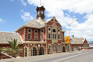
Wynberg is a southern suburb of the City of Cape Town in Western Cape, South Africa. It is situated between Plumstead and Kenilworth, and is a main transport hub for the Southern Suburbs of Cape Town.

The M3 is an expressway in Cape Town, South Africa, connecting the upper part of the City Bowl to the Southern Suburbs and ending in Tokai. For most of its route it parallels - though further to the south and west - the M4, which was the original road connecting central Cape Town with the settlements to the south.

Milnerton is a seaside town on Table Bay and is located north of Cape Town in South Africa. It is located 11 kilometres to the north of the city's centre.

The Southern Suburbs are a group of Anglophone suburbs in Cape Town, Western Cape, South Africa. This group includes, among others, Observatory, Mowbray, Pinelands, Rosebank, Rondebosch, Rondebosch East, Newlands, Claremont, Lansdowne, Kenilworth, Bishopscourt, Constantia, Wynberg, Ottery, Plumstead, Diep River, Bergvliet and Tokai. The area is also commonly referred to as the Cape Peninsula, often including the towns further South such as Fish Hoek.

Metrorail Western Cape is a network of commuter and suburban rail services in the City of Cape Town Metropolitan Municipality and in the surrounding towns of Malmesbury, Paarl, Stellenbosch and Wellington in the Western Cape province of South Africa.

Mowbray is one of the Southern Suburbs of Cape Town, South Africa and lies on the slopes of Devil's Peak. Mowbray is at a junction of several major Cape Town highways and has an important multi-modal public transport interchange at Mowbray railway station. Its original name was Driekoppen.
Kenilworth is a suburb in Cape Town, South Africa.
The Southern Line is a commuter rail line operated by Metrorail Western Cape, connecting Cape Town station in central Cape Town, South Africa with the Southern Suburbs and the towns on the west coast of False Bay, terminating in Simon's Town.
Retreat is a suburb in Cape Town, South Africa.
Steenberg Estate is the site of the oldest farm in Cape Town, located in the suburb of Constantia. Steenberg is translates as “Mountain of Stone” and is named for the nearby mountain range. The manor house and other buildings on the farm have been declared a national monument. The estate has been redeveloped as a hotel, vineyard and golf course.

Steenberg railway station is a Metrorail station on the Southern Line in Steenberg, a suburb of Cape Town. It is located on Henley Road, which is just off Military Road. The station is located on the edge of Steenberg, towards Kirstenhof and is alongside the Keyser River, which flows into Zandvlei.

Ou Kaapse Weg, numbered as route M64, is a mountain pass in the Cape Peninsula that connects the Southern Suburbs of Cape Town with the Fish Hoek Valley. It traverses the Steenberg mountains and passes through the Silvermine Nature Reserve. Ou Kaapse Weg is one of three routes to the Fish Hoek Valley: the others are Chapman's Peak Drive along the Atlantic coast and Main Road along the False Bay coast.

The following outline is provided as an overview of and topical guide to Cape Town:

