Northern Suburbs, Cape Town

Last updated
Northern Suburbs
Region
Paarl from Tygerberg Hill.jpg
View of Bellville from Tygerberg Hill
South Africa Western Cape location map.svg
Red pog.svg
Northern Suburbs
South Africa adm location map.svg
Red pog.svg
Northern Suburbs
Coordinates: 33°54′00″S18°38′00″E / 33.90000°S 18.63333°E / -33.90000; 18.63333
Country South Africa
Province Western Cape
Municipality City of Cape Town
Time zone UTC+2 (SAST)

The Northern Suburbs is a major urban and rural region located in the City of Cape Town Metropolitan Municipality in the Western Cape province of South Africa. It is the urban north-eastern part of the Greater Cape Town metropolitan area (Cape Metropole) that is functionally merged with Cape Town.

Contents

Geography

The region extends from Goodwood in the west to Kraaifontein, Brackenfell and Kuilsrivier in the east and north up to incorporate the rural village of Philadelphia. [1] [2]

The principal town is Bellville to the south of the Tygerberg Hills, which as of 2011 has a population of 112,507. Along with Bellville, the population density of the Northern Suburbs is concentrated along the N1 corridor including the towns of Goodwood (pop. 50,285), Parow (pop. 119,462), Brackenfell (44,842) and Kraaifontein (154,615). Bordering Bellville to the north amongst the Tygerberg Hills is the town of Durbanville (pop. 54,286) and along the R300 corridor bordering Bellville and Brackenfell is the town of Kuilsrivier (pop. 46,685). [3] [4] [5] Though separate, these aforementioned towns have virtually become one due to development and urban sprawl and as a result have become known as the northern suburbs of Cape Town.

The Northern Suburbs’ borders encompass the vibrant townships of Bloekombos, Wallacedene and Scottsdene in Kraaifontein and the smaller township of Fisantekraal (pop. 12,369) just outside Durbanville.

Towards the extreme north of the Northern Suburbs about 20 kilometres (12.4 mi) from Durbanville are the rural settlements of Klipheuwel (pop. 2,294) and Philadelphia (pop. 570) which are the most isolated and least integrated areas within the Greater Cape Town metropolitan area.

Transportation

Roads

The Northern Suburbs mainly lies along the N1 freeway which traverses through Goodwood, Parow, Bellville, Brackenfell and Kraaifontein and leads south-west to Cape Town and north-east to Paarl and Worcester. The R300 freeway (Kuils River Freeway) connects the suburbs towards the east including Bellville, Brackenfell and Kuilsrivier and leads south to Mitchells Plain on the Cape Flats. The N7 freeway lies to the far west of the Northern Suburbs linking Goodwood with Malmesbury to the north. [6]

Rail

The Metrorail Western Cape commuter rail system connects Cape Town to the northern suburbs of Goodwood, Parow, Bellville, Brackenfell and Kraaifontein via the Northern Line and also connects Strand and Somerset West in the Helderberg region to the northern suburbs of Kuilsrivier and Bellville via the Strand Line.

Related Research Articles

<span class="mw-page-title-main">Bellville, South Africa</span> Town in Western Cape, South Africa.

Bellville is a town and former independent city that is now incorporated into the City of Cape Town Metropolitan Municipality in the Western Cape province of South Africa. The town is an industrial and commercial node, a university town, and a major transportation hub within the Greater Cape Town metropolis.

<span class="mw-page-title-main">R300 (South Africa)</span> Road in South Africa

The R300 or Kuils River Freeway is a Regional Route in the Cape Metropole, South Africa that connects Mitchells Plain with the N2, Kuils River, and the N1 at Bellville. The R300 is a freeway for its entire length; it forms part of the proposed Peninsula Expressway.

<span class="mw-page-title-main">Somerset West</span> Town in the Western Cape, South Africa

Somerset West is a town in the Western Cape, South Africa. Organisationally and administratively it is included in the City of Cape Town metropolitan municipality as a suburb of the Helderberg region . The vehicle registration code for Somerset West is CFM and the post code is 7130 for street addresses, and 7129 for post office boxes.

<span class="mw-page-title-main">Kraaifontein</span> Place in Western Cape, South Africa

Kraaifontein is a town in the Western Cape province of South Africa and is located on the north-eastern outskirts of the City of Cape Town Metropolitan Municipality.

<span class="mw-page-title-main">City of Cape Town</span> Metropolitan municipality in Western Cape, South Africa

The City of Cape Town is the local government of Cape Town and surrounding areas. As of the 2011 census, it had a population of 3,740,026.

<span class="mw-page-title-main">Brackenfell</span> Town in the Western Cape, South Africa

Brackenfell is a railway town in the Western Cape province of South Africa and a northern suburb of Cape Town. It lies at the gateway to the Cape Winelands approximately halfway between Cape Town – 30 km and Paarl – 35 km.

<span class="mw-page-title-main">Tygerberg</span> Region of the City of Cape Town, South Africa

Tygerberg is a district in the northern suburbs of Cape Town in South Africa. It is also the name of the range of hills in the area. The main Tygerberg farms were Pampoenkraal, Stellenburgh, Evertsdal, De Grendel, Lebenstijn, Blommensteijn, Door de Kraal, Vissershok and Clara Anna Fontein. It also contains the Tygerberg Nature Reserve.

<span class="mw-page-title-main">Durbanville</span> Town in Western Cape, South Africa

Durbanville is a town in the Western Cape province of South Africa, part of the greater Cape Town metropolitan area. Durbanville is a semi-rural residential suburb on the north-eastern outskirts of the metropolis surrounded by farms producing wine and wheat.

<span class="mw-page-title-main">Milnerton</span> Seaside town in the Western Cape, South Africa

Milnerton is a seaside town on Table Bay and is located north of Cape Town in South Africa. It is located 11 kilometres to the north of the city's centre.

<span class="mw-page-title-main">Metrorail Western Cape</span> Commuter rail system in the Greater Cape Town area

Metrorail Western Cape is a network of commuter and suburban rail services in the City of Cape Town Metropolitan Municipality and in the surrounding towns of Malmesbury, Paarl, Stellenbosch and Wellington in the Western Cape province of South Africa.

Origin South Africa is a non-denominational Christian agency founded in 2005 as a daughter ministry of Origin Scotland. It was formed to promote unity and outreach in the Church in Cape Town, South Africa. It is a registered NPO, Registration No: 055-618-NPO. It operates from headquarters in Durbanville, South Africa, in the Northern suburbs of Cape Town.

The Northern Line is a commuter rail service in South Africa that in the Cape Town metropolitan area and its surroundings and is operated by Metrorail Western Cape. Northern Line services operate from central Cape Town to Bellville, and then from Bellville along three different routes. The first route runs along the main Cape Town–De Aar railway line to Paarl and Wellington. The second route passes through Stellenbosch to terminate at Muldersvlei station on the main line, while the third also passes through Somerset West to terminate in Strand.

The R101 is a Regional Route in South Africa that is the designation for some of the old sections of roads that were previously the N1, prior to upgrading. It only has 2 sections, from Bellville to Worcester and from Johannesburg to Polokwane.

Richwood is a small Richwood is an outer northern suburb of Cape Town, South Africa and is about 15 kilometres (9.3 mi) north-east of the city alongside the N7 freeway. According to the 2011 census it has a population of 2,988 residents in 963 households. The name is a portmanteau of "Richmond Park" and "Goodwood".

<span class="mw-page-title-main">Northlink College</span> College in South Africa

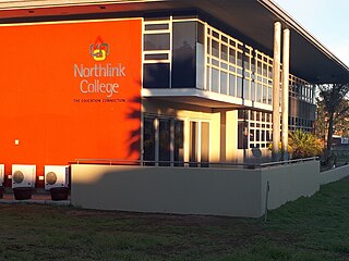
Northlink College is a Government higher education institution situated in Bellville, Western Cape, South Africa. It is fully accredited by the Council on Higher Education and Department of Higher Education and Training (DoHET)(South Africa). The College is quality assured by the South African Council on Higher Education (CHE).

<span class="mw-page-title-main">Outline of Cape Town</span> List of links to articles about Cape Town on Wikipedia

The following outline is provided as an overview of and topical guide to Cape Town:

The M12 is a long metropolitan route in the City of Cape Town, South Africa. It connects Burgundy Estate with Stellenbosch via Parow, Elsie's River and Kuils River.

References

  1. https://ontheworldmap.com/south-africa/city/cape-town/cape-town-suburbs-map.html
  2. https://ontheworldmap.com/south-africa/city/cape-town/northern-suburbs-map.html
  3. "NORTHERN SUBURBS, Cape Town". www.sa-venues.com. Retrieved 2023-07-27.
  4. https://www.capetown.travel/areas/northern-suburbs/
  5. "Cape Town Northern Suburbs | Expat Guide to Durbanville and Northern Suburbs". Expat Cape Town. Retrieved 2023-07-27.
  6. "Northern suburbs – Travel | Wesgro". wesgro.co.za. Retrieved 2023-07-27.