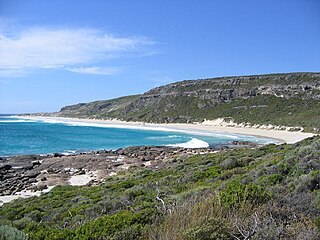
Leeuwin-Naturaliste National Park is a national park in the South West region of Western Australia, 267 km (166 mi) south of Perth. It is named after the two locations at either end of the park which have lighthouses, Cape Leeuwin and Cape Naturaliste. It is located in the Augusta-Margaret River and Busselton council areas, and is claimed to have the highest visiting numbers of any national park in Western Australia. The park received 2.33 million visitors through 2008–2009.

Sclerophyll is a type of vegetation that is adapted to long periods of dryness and heat. The plants feature hard leaves, short internodes and leaf orientation which is parallel or oblique to direct sunlight. The word comes from the Greek sklēros (hard) and phyllon (leaf). The term was coined by A.F.W. Schimper in 1898, originally as a synonym of xeromorph, but the two words were later differentiated.

Fynbos is a small belt of natural shrubland or heathland vegetation located in the Western Cape and Eastern Cape provinces of South Africa. This area is predominantly coastal and mountainous, with a Mediterranean climate and rainy winters. The fynbos ecoregion is within the Mediterranean forests, woodlands, and scrub biome. In fields related to biogeography, fynbos is known for its exceptional degree of biodiversity and endemism, consisting of about 80% species of the Cape floral kingdom, where nearly 6,000 of them are endemic. This land continues to face severe human-caused threats, but due to the many economic uses of the fynbos, conservation efforts are being made to help restore it.

The Carnarvon xeric shrublands is a deserts and xeric shrublands ecoregion of Western Australia. The ecoregion is coterminous with the Carnarvon Interim Biogeographic Regionalisation for Australia (IBRA) bioregion.

In biogeography, the Mediterranean Basin, also known as the Mediterranean Region or sometimes Mediterranea, is the region of lands around the Mediterranean Sea that have mostly a Mediterranean climate, with mild to cool, rainy winters and warm to hot, dry summers, which supports characteristic Mediterranean forests, woodlands, and scrub vegetation. It was a very important part of Mediterranean civilizations.

Mitchells Plain is a large census designated sub-place located within the City of Cape Town, Western Cape, South Africa and situated about 28 km (17 mi) from the Cape Town city centre. It is one of South Africa's largest residential areas and contains multiple smaller suburbs. It is located on the Cape Flats on the False Bay coast between Muizenberg and Khayelitsha. Conceived of as a "model suburb" by the apartheid government, it was built during the 1970s to provide housing for Coloured victims of forced removal due to the implementation of the Group Areas Act.
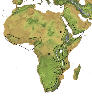
The Afromontane regions are subregions of the Afrotropical realm, one of the Earth's eight biogeographic realms, covering the plant and animal species found in the mountains of Africa and the southern Arabian Peninsula. The Afromontane regions of Africa are discontinuous, separated from each other by lower-lying areas, and are sometimes referred to as the Afromontane archipelago, as their distribution is analogous to a series of sky islands.

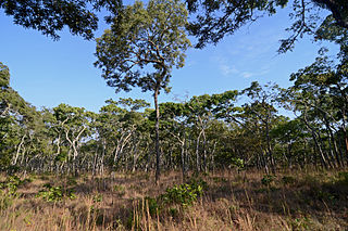
Warren, also known as Karri Forest Region and the Jarrah-Karri forest and shrublands ecoregion, is a biogeographic region in southern Western Australia. Located in the southwest corner of Western Australia between Cape Naturaliste and Albany, it is bordered to the north and east by the Jarrah Forest region. Its defining characteristic is an extensive tall forest of Eucalyptus diversicolor (karri). This occurs on dissected, hilly ground, with a moderately wet climate. Karri is a valuable timber and much of the karri forest has been logged over, but less than a third has been cleared for agriculture. Recognised as a region under the Interim Biogeographic Regionalisation for Australia (IBRA), and as a terrestrial ecoregion by the World Wide Fund for Nature, it was first defined by Ludwig Diels in 1906.
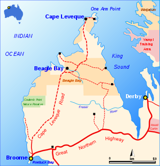
The Cape Leveque Road is a regional Western Australian road that runs through pindan woodland for 205 kilometres (127 mi) between Broome and Cape Leveque on the Dampier Peninsula.

The Dampier Peninsula is a peninsula located north of Broome and Roebuck Bay in the Kimberley region of Western Australia. It is surrounded by the Indian Ocean to the west and north, and King Sound to the east. It is named after the mariner and explorer William Dampier who visited it. The northernmost part of the peninsula is Cape Leveque. It is sparsely inhabited, mostly by Indigenous Australian peoples, some of whom have been granted native title rights to some of their traditional lands. There are many coastal inlets, bays and other features, including Beagle Bay on its western side.

The grey-headed kingfisher is a species of kingfisher that has a wide distribution from the Cape Verde Islands off the north-west coast of Africa to Mauritania, Senegal and Gambia, east to Ethiopia, Somalia and southern Arabia and south to South Africa.
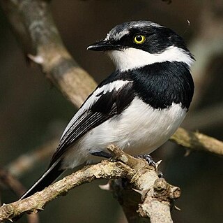
The chinspot batis is a small songbird of the genus Batis in the family Platysteiridae which is a common and widespread species in the woodlands of southern Africa from the Eastern Cape north to 3°N in southern Kenya and Gabon. It forms a superspecies with other rather similar members of the genus Batis.
The Ducie River is a river located on the Cape York Peninsula in Far North Queensland, Australia.
The Central Zambezian miombo woodlands ecoregion spans southern central Africa. Miombo woodland is the predominant plant community. It is one of the largest ecoregions on the continent, and home to a great variety of wildlife, including many large mammals.

Renosterveld is a term used for one of the major plant communities and vegetation types of the Cape Floristic Region which is located in southwestern and southeastern South Africa, in southernmost Africa. It is an ecoregion of the Mediterranean forests, woodlands, and scrub biome.

Southern Afrotemperate Forest is a kind of tall, shady, multilayered indigenous South African forest. This is the main forest-type in the south-western part of South Africa, naturally extending from the Cape Peninsula in the west, as far as Port Elizabeth in the east. In this range, it usually occurs in small forest pockets, surrounded by fynbos vegetation.

Mediterranean forests, woodlands and scrub is a biome defined by the World Wide Fund for Nature. The biome is generally characterized by dry summers and rainy winters, although in some areas rainfall may be uniform. Summers are typically hot in low-lying inland locations but can be cool near colder seas. Winters are typically mild to cool in low-lying locations but can be cold in inland and higher locations. All these ecoregions are highly distinctive, collectively harboring 10% of the Earth's plant species.
Cape Torrens Wilderness Protection Area, formerly the Cape Torrens Conservation Park and the Cape Torrens National Park, is a protected area on Kangaroo Island, South Australia. It was originally dedicated on 21 January 1971 to conserve remnant native vegetation with outstanding coastal and cliff scenery and proclaimed as a wilderness protection area on 15 October 1993.
Annan River National Park is a national park on Cape York Peninsula in Far North Queensland, Australia. The Annan River from which the park gets its name, marks the northern and western extent of the park. To the east of the park is Walker Bay in the Coral Sea. The park was gazetted in 2006.


