Cape Town is one of South Africa's three capital cities, serving as the seat of the Parliament of South Africa. It is the legislative capital of the country, the oldest city in the country, and the second largest. Colloquially named the Mother City, it is the largest city of the Western Cape province, and is managed by the City of Cape Town metropolitan municipality. The other two capitals are Pretoria, the executive capital, located in Gauteng, where the Presidency is based, and Bloemfontein, the judicial capital in the Free State, where the Supreme Court of Appeal is located.

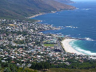
Camps Bay is an affluent suburb of Cape Town, South Africa, and the small bay on the west coast of the Cape Peninsula after which it is named. In summer it attracts many South African and foreign visitors.

The Cape Peninsula is a generally mountainous peninsula that juts out into the Atlantic Ocean at the south-western extremity of the African continent. At the southern end of the peninsula are Cape Point and the Cape of Good Hope. On the northern end is Table Mountain, overlooking Table Bay and the city bowl of Cape Town, South Africa. The peninsula is 52 km long from Mouille point in the north to Cape Point in the south. The Peninsula has been an island on and off for the past 5 million years, as sea levels fell and rose with the ice age and interglacial global warming cycles of, particularly, the Pleistocene. The last time that the Peninsula was an island was about 1.5 million years ago. Soon afterwards it was joined to the mainland by the emergence from the sea of the sandy area now known as the Cape Flats. The towns and villages of the Cape Peninsula and Cape Flats, and the undeveloped land of the rest of the peninsula now form part of the City of Cape Town metropolitan municipality. The Cape Peninsula is bounded to the north by Table Bay, to the west by the open Atlantic Ocean, and to the east by False Bay in the south and the Cape Flats in the north.

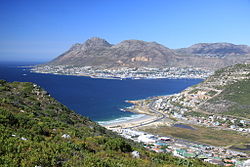
Simon's Town, sometimes spelled Simonstown, is a town in the Western Cape, South Africa and is home to Naval Base Simon's Town, the South African Navy's largest base. It is located on the shores of False Bay, on the eastern side of the Cape Peninsula. For more than two centuries it has been a naval base and harbour. The town is named after Simon van der Stel, an early governor of the Cape Colony.

False Bay is a body of water in the Atlantic Ocean between the mountainous Cape Peninsula and the Hottentots Holland Mountains in the extreme south-west of South Africa. The mouth of the bay faces south and is demarcated by Cape Point to the west and Cape Hangklip to the east. The north side of the bay is the low-lying Cape Flats, and the east side is the foot of the Hottentots Holland Mountains to Cape Hangklip which is at nearly the same latitude as Cape Point. In plan the bay is approximately square, being roughly the same extent from north to south as east to west, with the southern side open to the ocean. The seabed slopes gradually down from north to south, and is mostly fairly flat unconsolidated sediments. Much of the bay is off the coast of the City of Cape Town, and it includes part of the Table Mountain National Park Marine Protected Area and the whole of the Helderberg Marine Protected Area. The name "False Bay" was applied at least three hundred years ago by sailors returning from the east who confused Cape Point and Cape Hangklip, which are somewhat similar in form.

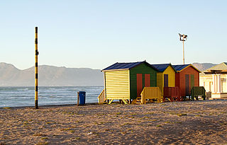
Muizenberg is a beach-side town in the Western Cape, South Africa. It is situated where the shore of the Cape Peninsula curves round to the east on the False Bay coast. It is considered to be the main surfing spot in Cape Town and is currently home to a surfing community, centered on the popular 'Surfer's Corner'.

False Cape State Park is a 4,321-acre (17.49 km2) state park located on the Currituck Banks Peninsula, a one-mile-wide (1.6 km) barrier spit between the Back Bay of the Currituck Sound and the Atlantic Ocean, within the city of Virginia Beach, adjacent to the state border with North Carolina, and just north of Mackay Island National Wildlife Refuge.

Noordhoek is a seaside town in the Western Cape, South Africa, located below Chapman's Peak on the west coast of the Cape Peninsula and is approximately 35 kilometres (22 mi) to the south of Cape Town. The name "Noordhoek" was taken from Dutch and literally means "north corner". It was given this name in 1743 as being the northern corner of the Slangkop farm. The first permanent resident of European origin is Jaco Malan who built his house there. In 1857, the region was divided into six plots, most of which were bought by a single family, that of the de Villiers. Noordhoek nevertheless remains a predominantly rural area where farmers grow vegetables to supply ships calling at Simon's Town. It is best known for its shoreline and its long, wide, sandy beach, which stretches south to the neighbouring village of Kommetjie. Near the southern end of this beach is the wreck of the steamship "Kakapo", which ran aground in 1900, when the captain mistook Chapman's Peak for the Cape of Good Hope and put the helm over to port.

The Cape Metropole has a wide variety of beaches divided into three regions by the Cape Peninsula:

Boulders Beach is a sheltered beach made up of inlets between granite boulders, from which the name originated. It is located on the Cape Peninsula, in Simon's Town, a suburb of Cape Town in the Western Cape province of South Africa. It is also commonly known as Boulders Bay. It is a popular tourist spot because of a colony of African penguins which settled there in 1982. Boulders Beach forms part of the Table Mountain National Park.

The Southern Line is a commuter rail line operated by Metrorail Western Cape, connecting Cape Town station in central Cape Town, South Africa with the Southern Suburbs and the towns on the west coast of False Bay, terminating in Simon's Town.

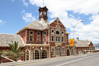
Simon's Town railway station is a Metrorail railway station in the town of Simon's Town on the Cape Peninsula; it is the southern terminus of the Southern Line. The station is located between Station Road and the beach.

The M7, also named Jakes Gerwel Drive, is a limited-access road and metropolitan route in the City of Cape Town, South Africa. It connects Acacia Park with Rocklands on the False Bay Coast via the Cape Flats.

Cape Town lies at the south-western corner of the continent of Africa. It is bounded to the south and west by the Atlantic Ocean, and to the north and east by various other municipalities in the Western Cape province of South Africa.

Miller's Point is a headland and stretch of protected coastline in South Africa. It is located about 4 kilometres (2.5 mi) south of Simon's Town on the road to Cape Point.

The Table Mountain National Park Marine Protected Area is an inshore marine protected area around the Cape Peninsula, in the vicinity of Cape Town, South Africa. It was proclaimed in Government Gazette No. 26431 of 4 June 2004 in terms of the Marine Living Resources Act, 18 of 1998.

The M4 is a long metropolitan route in the City of Cape Town Metropolitan Municipality in South Africa. It connects the Cape Town CBD with the Cape Peninsula via Wynberg, Muizenberg and Fish Hoek. Originally, it was the main route connecting the Cape Town CBD with the Southern Suburbs. From the CBD to Kirstenhof, it is parallel to the M3 Freeway.

The M6 is a short metropolitan route in Cape Town, South Africa. It connects the Cape Town CBD with Glencairn on the False Bay coast via Sea Point, Camps Bay and Hout Bay. It is an alternative route to the M4 for travel between Cape Town CBD and Glencairn, with the M6 passing to the west of Table Mountain.


