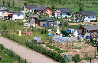
An allotment, or in North America, a community garden, is a plot of land made available for individual, non-commercial gardening or growing food plants, so forming a kitchen garden away from the residence of the user. Such plots are formed by subdividing a piece of land into a few or up to several hundred parcels that are assigned to individuals or families. Such parcels are cultivated individually, contrary to other community garden types where the entire area is tended collectively by a group of people. In countries that do not use the term "allotment (garden)", a "community garden" may refer to individual small garden plots as well as to a single, large piece of land gardened collectively by a group of people. The term "victory garden" is also still sometimes used, especially when a community garden dates back to the First or Second World War.

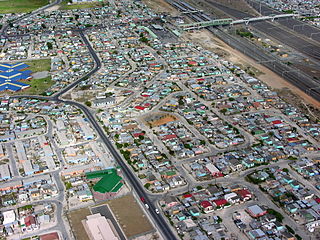
The Cape Flats is an expansive, low-lying, flat area situated to the southeast of the central business district of Cape Town. The Cape Flats is also the name of an administrative region of the City of Cape Town, which lies within the larger geographical area.

Urban agriculture refers to various practices of cultivating, processing, and distributing food in urban areas. The term also applies to the area activities of animal husbandry, aquaculture, beekeeping, and horticulture in an urban context. Urban agriculture is distinguished from peri-urban agriculture, which takes place in rural areas at the edge of suburbs.

South African cuisine reflects the diverse range of culinary traditions embodied by the various communities that inhabit the country. Among the indigenous peoples of South Africa, the Khoisan foraged over 300 species of edible food plants, such as the rooibos shrub legume, whose culinary value continues to exert a salient influence on South African cuisine. Subsequent encounters with Bantu pastoralists facilitated the emergence of cultivated crops and domestic cattle, which supplemented traditional Khoisan techniques of meat preservation. In addition, Bantu-speaking communities forged an extensive repertoire of culinary ingredients and dishes, many of which are still consumed today in traditional settlements and urban entrepôts alike.

Khayelitsha is a township in Western Cape, South Africa, on the Cape Flats in the City of Cape Town Metropolitan Municipality. The name is Xhosa for New Home. It is reputed to be one of the largest and fastest-growing townships in South Africa.

Mitchells Plain is a large township located within the City of Cape Town, Western Cape, South Africa and situated about 28 km (17 mi) from the Cape Town city centre. It is one of South Africa's largest residential areas and contains multiple smaller suburbs. It is located on the Cape Flats on the False Bay coast between Muizenberg and Khayelitsha. Conceived of as a "model suburb" by the apartheid government, it was built during the 1970s to provide housing for Coloured victims of forced removal due to the implementation of the Group Areas Act.
The area known today as Cape Town has no written history before it was first mentioned by Portuguese explorer Bartholomeu Dias in 1488. The German anthropologist Theophilus Hahn recorded that the original name of the area was '||Hui !Gais' – a toponym in the indigenous Khoe language meaning "where clouds gather."

Helderberg refers to a planning district of the City of Cape Town metropolitan municipality, the mountain after which it is named, a wine-producing area in the Western Cape province of South Africa, or a small census area in Somerset West.

Crossroads is a high-density township in the Western Cape, South Africa.

Urban horticulture is the science and study of the growing plants in an urban environment. It focuses on the functional use of horticulture so as to maintain and improve the surrounding urban area. Urban horticulture has seen an increase in attention with the global trend of urbanization and works to study the harvest, aesthetic, architectural, recreational and psychological purposes and effects of plants in urban environments.
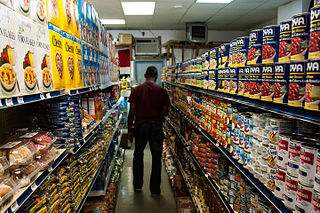
A food desert is an area that has limited access to affordable and nutritious food. In contrast, an area with greater access to supermarkets and vegetable shops with fresh foods may be called a food oasis. The designation considers the type and the quality of food available to the population, in addition to the accessibility of the food through the size and the proximity of the food stores.

Organic farming is practiced around the globe, but the markets for sale are strongest in North America and Europe, while the greatest dedicated area is accounted for by Australia, the greatest number of producers are in India, and the Falkland Islands record the highest share of agricultural land dedicated to organic production.
Afrikaners are a Southern African ethnic group descended from predominantly Dutch settlers first arriving at the Cape of Good Hope in 1652. Until 1994, they dominated South Africa's politics as well as the country's commercial agricultural sector. Afrikaners make up approximately 5.2% of the total South African population, based upon the number of White South Africans who speak Afrikaans as a first language in the South African National Census of 2011. Afrikaans, South Africa's third most widely spoken home language, evolved as the mother tongue of Afrikaners and most Cape Coloureds. It originated in the Dutch vernacular of South Holland, incorporating words brought from the Dutch East Indies and Madagascar by slaves.

Delft is a township on the outskirts of Cape Town, South Africa. It is situated next to the Cape Town International Airport, Belhar, Blue Downs, Ikwezi Park, Mandalay,Luzuko, Phillipi East and Site C, Khayelitsha. It is known for its recreational events, youth empowerment organizations such as Enkosi Foundation and the community has establish a motherbody organisation, the Delft Community Development Forum. Delft is a community that consists of numerous government built housing projects such as the N2 Gateway. In 2022 Delft was the fastest growing community in Cape Town.

Philippi is a large urban and semi-urban area in Cape Town's Cape Flats region, in the Western Cape, South Africa. It comprises the Philippi Horticultural Area to the west, and the neighbourhoods of Brown's Farm, Philippi East and Samora Machel located within its eastern half. The neighbourhoods of Gugulethu and Nyanga are located to its north. The horticultural area is sparsely populated compared to the surrounding city and contains many farms.
The Central Line is a commuter rail service in Cape Town, South Africa, operated by Metrorail Western Cape. Central Line services operate along two routes from central Cape Town to Langa, and then along three branches from Langa to various areas in the south-east of the city. The first branch runs to Mitchell's Plain, the second to Khayelitsha, and the third passes through Belhar to terminate in Bellville.

Murraysburg is an Afrikaans speaking town of approximately 5,000 people in the Western Cape province of South Africa. It is situated in the far northeast of the municipality, about 540 kilometres (340 mi) from the provincial capital Cape Town, and 80 kilometres (50 mi) west of Graaff-Reinet. It is governed as part of the Beaufort West Local Municipality within the Central Karoo District Municipality.

Hanover Park is a neighborhood of the City of Cape Town in the Western Cape province of South Africa

Foodscaping is a modern term for the practice of integrating edible plants into ornamental landscapes. It is also referred to as edible landscaping and has been described as a crossbreed between landscaping and farming. As an ideology, foodscaping aims to show that edible plants are not only consumable but can also be appreciated for their aesthetic qualities. Foodscaping spaces are seen as multi-functional landscapes which are visually attractive and also provide edible returns. Foodscaping is a great way to provide fresh food in an affordable way.
The Brown's Farm area is a neighborhood located within the Philippi area of Cape Town's Cape Flats region, in the Western Cape province of South Africa. The urban area is densely populated and contains many informal homes. The 2011 national census recorded 71,518 residents living in the area.


