Signal Hill (Cape Town)

Last updated

Signal Hill
Lions Head & Signal Hill wza.jpg
Lion's Head and Signal Hill from the summit of Table Mountain with Robben Island in Table Bay.
Highest point
Elevation 350 m (1,150 ft)
Coordinates 33°55′4″S18°24′10″E / 33.91778°S 18.40278°E / -33.91778; 18.40278 (Signal Hill) Coordinates: 33°55′4″S18°24′10″E / 33.91778°S 18.40278°E / -33.91778; 18.40278 (Signal Hill)
Geography
Location Western Cape, South Africa
Geology
Age of rock Late Precambrian
Climbing
Easiest route Signal Hill Rd

Signal Hill (Afrikaans : Seinheuwel), [1] or Lion's Rump, is a landmark flat-topped hill located in Cape Town, next to Lion's Head and Table Mountain.

Contents

The hill was also known as "The Lion's Flank", a term now obsolete. Together with Lion's Head, Signal Hill looks like a lion sphinx. [2]

Signals

Signal flags were used to communicate weather warnings as well as anchoring instructions to visiting ships in order to ensure that they prepared adequately for stormy weather while in the bay. Similarly, ships could use flags to signal for assistance if, for example, an anchor line parted during a storm. [3]

It is known for the Noon Gun that is operated there by the South African Navy and South African Astronomical Observatory. In 1836, a time ball was set up at the Cape Town observatory, [4] however it was not visible to ships in the harbour, so a second time ball was erected on Signal Hill in order to relay the precise moment of 1pm Cape Mean Time. In this way ships in the bay were able to check their marine chronometers. [3] The daily practice of dropping of the ball continued until 1934, when it was made redundant by radio signals. [5]

The guns on Signal Hill were used to notify the public when a ship was in trouble and there was a possibility of casualties on the coast near Cape Town. Three guns would be fired from Chavonnes Battery, followed by a single gun in answer from Imhoff Battery. [3]

Structures

A view of the kramat (tomb for a Muslim) towards Lion's Head from the Signal Hill hiking trail Signal-Hill-051.jpg
A view of the kramat (tomb for a Muslim) towards Lion's Head from the Signal Hill hiking trail

There is a road to the summit and that vantage point provides views over the Cape Town city centre and Atlantic Seaboard and surroundings, including at dawn or sunset. Along Signal Hill Road is the Appleton Scout Campsite [6] operated by Scouts South Africa.

There are several tombs, or kramat s, on the hill for Muslim missionaries and religious leaders. The most conspicuous one, a white square building with a green dome, is for the sheikh Mohamed Hassen Ghaibie (Shah al-Qadri), a follower of Sheikh Yusuf. Other tombs consist of raised rectangles, decorated with satin. They are still visited by some local Muslim people.[ citation needed ]

There is a parking lot on top of the signal Hill. There are simple things to eat and mats provided for watching the sunset.

Ecology

Signal Hill is one of the only places in the world where critically endangered Peninsula Shale Renosterveld vegetation can be found.[ citation needed ] Peninsula Shale Renosterveld used to be the dominant ecosystem of the Cape Town City Bowl, but was completely endemic, occurring nowhere else in the world.

Urban growth has now covered most of this ecosystem and — along with a tiny patch on Devil's Peak — Signal Hill has the only surviving sample of this vegetation in the world. [7]

See also

Related Research Articles

<span class="mw-page-title-main">Table Mountain</span> Flat-topped mountain overlooking the city of Cape Town, South Africa

Table Mountain is a flat-topped mountain forming a prominent landmark overlooking the city of Cape Town in South Africa. It is a significant tourist attraction, with many visitors using the cableway or hiking to the top. Table Mountain National Park is the most visited national park in South Africa, attracting 4.2 million people every year for various activities. The mountain has 8,200 plant species, of which around 80% are fynbos, meaning fine bush. It forms part of the Table Mountain National Park, and part of the lands formerly ranged by Khoe-speaking clans, such as the !Uriǁʼaes. It is home to a large array of mostly endemic fauna and flora.

<span class="mw-page-title-main">Time signal</span> Signal used as a reference to determine the time of day

A time signal is a visible, audible, mechanical, or electronic signal used as a reference to determine the time of day.

<span class="mw-page-title-main">Fynbos</span> Shrubland and heathland ecoregion of southwestern South Africa

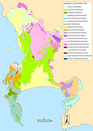
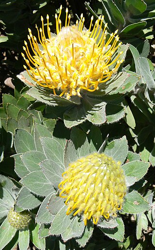
Fynbos is a small belt of natural shrubland or heathland vegetation located in the Western Cape and Eastern Cape provinces of South Africa. This area is predominantly coastal and mountainous, with a Mediterranean climate and rainy winters. The fynbos ecoregion is within the Mediterranean forests, woodlands, and scrub biome. In fields related to biogeography, fynbos is known for its exceptional degree of biodiversity and endemism, consisting of about 80% species of the Cape floral kingdom, where nearly 6,000 of them are endemic. This land continues to face severe human-caused threats, but due to the many economic uses of the fynbos, conservation efforts are being made to help restore it.

<span class="mw-page-title-main">Devil's Peak (Cape Town)</span> Mountain peak in Cape Town, South Africa

Devil's Peak is part of the mountainous backdrop to Cape Town, South Africa. When looking at Table Mountain from the city centre, or when looking at the standard picture postcard view of the mountain, the skyline is from left to right: the spire of Devil's Peak, the flat mesa of Table Mountain, the dome of Lion's Head and Signal Hill.

<span class="mw-page-title-main">Noon Gun</span> Historic time signal in Cape Town, South Africa since 1806

The Noon Gun has been a historic time signal in Cape Town, South Africa since 1806. It consists of a pair of black powder Dutch naval guns, fired alternatingly with one serving as a backup. The guns are situated on Signal Hill, close to the centre of the city.

<span class="mw-page-title-main">Cape Peninsula</span> Rocky peninsula in the Western Cape, South Africa

The Cape Peninsula is a generally mountainous peninsula that juts out into the Atlantic Ocean at the south-western extremity of the African continent. At the southern end of the peninsula are Cape Point and the Cape of Good Hope. On the northern end is Table Mountain, overlooking Table Bay and the city bowl of Cape Town, South Africa. The peninsula is 52 km long from Mouille point in the north to Cape Point in the south. The Peninsula has been an island on and off for the past 5 million years, as sea levels fell and rose with the ice age and interglacial global warming cycles of, particularly, the Pleistocene. The last time that the Peninsula was an island was about 1.5 million years ago. Soon afterwards it was joined to the mainland by the emergence from the sea of the sandy area now known as the Cape Flats. The towns and villages of the Cape Peninsula and Cape Flats, and the undeveloped land of the rest of the peninsula now form part of the City of Cape Town metropolitan municipality. The Cape Peninsula is bounded to the north by Table Bay, to the west by the open Atlantic Ocean, and to the east by False Bay in the south and the Cape Flats in the north.

<span class="mw-page-title-main">Lion's Head (Cape Town)</span> Mountain in Cape Town, South Africa

Lion's Head is a mountain in Cape Town, South Africa, between Table Mountain and Signal Hill. Lion's Head peaks at 669 metres (2,195 ft) above sea level. The peak forms part of a dramatic backdrop to the city of Cape Town and is part of the Table Mountain National Park.

<span class="mw-page-title-main">Cape Floristic Region</span> Smallest of the six recognised floral kingdoms of the world

The Cape Floristic Region is a floristic region located near the southern tip of South Africa. It is the only floristic region of the Cape Floristic Kingdom, and includes only one floristic province, known as the Cape Floristic Province.

<span class="mw-page-title-main">Renosterveld</span> Vegetation type and plant community of the Cape Floristic Region

Renosterveld is a term used for one of the major plant communities and vegetation types of the Cape Floristic Region which is located in southwestern and southeastern South Africa, in southernmost Africa. It is an ecoregion of the Mediterranean forests, woodlands, and scrub biome.

<span class="mw-page-title-main">Klapmuts</span> Place in Western Cape, South Africa

Klapmuts is the name of both a hill, and a town which formed at its foot. They are located in Cape Winelands District Municipality in the Western Cape province of South Africa.

<i>Euphorbia caput-medusae</i> Species of flowering plant in the spurge family Euphorbiaceae

Euphorbia caput-medusae is a plant of the genus Euphorbia that occurs in and around Cape Town, South Africa.

<span class="mw-page-title-main">Biodiversity of Cape Town</span> Diversity of the natural environment of Cape Town

The Biodiversity of Cape Town is the variety and variability of life within the geographical extent of the City of Cape Town metropolitan municipality, excluding the Prince Edward Islands. The terrestrial vegetation is particularly diverse and much of it is endemic to the city and its vicinity. Terrestrial and freshwater animal life is heavily impacted by urban development and habitat degradation. Marine life of the waters immediately adjacent to the city along the Cape Peninsula and in False Bay is also diverse, and while also impacted by human activity, the habitats are relatively intact.

<span class="mw-page-title-main">Peninsula Granite Fynbos</span> Vegetation type endemic to the city of Cape Town, South Africa

Peninsula Granite Fynbos is an endangered Fynbos vegetation type which is endemic to the city of Cape Town and occurs nowhere else. It is a unique type of tall, dense and diverse scrubland, scattered with trees. It can be found all along the belt of granite that encircles Table Mountain.

<span class="mw-page-title-main">Peninsula Shale Renosterveld</span> Vegetation type found only in South Africa

Peninsula Shale Renosterveld (PSR) is a unique vegetation type that is found only on the slopes of Signal Hill and Devil's Peak in Cape Town, South Africa. It is critically endangered and exists nowhere else.

<i>Moraea aristata</i> Species of plant in the family Iridaceae

Moraea aristata is a species of flowering plant in the family Iridaceae. It is referred to by the common names blue-eyed uintjie or Blouooguintjie in Afrikaans and is a critically endangered species of plant in the genus Moraea, that is endemic to the city of Cape Town and is now restricted to the grounds of the Observatory in the Cape Town suburb of Observatory.

<span class="mw-page-title-main">Swartland Shale Renosterveld</span> Vegetation type endemic to the Western Cape, South Africa

Swartland Shale Renosterveld is a critically endangered vegetation type of the Western Cape, South Africa.

<span class="mw-page-title-main">Cape Winelands Shale Fynbos</span> Vegetation type endemic to the Boland of the Western Cape, South Africa.

Cape Winelands Shale Fynbos is a vegetation type that naturally occurs in the Cape Winelands of the Western Cape, South Africa.

<span class="mw-page-title-main">Tygerberg Nature Reserve</span> Nature reserve in Cape Town, South Africa

Tygerberg Nature Reserve is a 300-hectare (740-acre) nature reserve on the Tygerberg Hills in the northern suburbs of Cape Town, South Africa.

Blaauwberg Nature Reserve was proclaimed a local and provincial nature reserve in 2007. The reserve has views down fynbos slopes, across the city, to seven kilometres of rocky and sandy coastline and the ocean and beyond. The reserve presents itself as one of the few viewpoints in the world from where you can see two proclaimed world heritage sites, namely Table Mountain and Robben Island.

References

  1. sein = ‘sign, beacon, flag’; heuwel = ‘hill’.
    Blok, Dirk Peter (1966). Proceedings of the Eighth International Congress of Onomastic Sciences. Mouton. p. 338. ISBN   9789027906090.
  2. Cape Town Magazine - Shooting in Cape Town with The Noon Gun
  3. 1 2 3 William Henry Rosser; James Frederick Imray (1867). The Seaman's Guide to the Navigation of the Indian Ocean and China Sea. J. Imray & Son. pp. 275–276. Retrieved 4 October 2008.
  4. Henry Colin Gray Matthew, Brian Howard Harrison, British Academy (2004). Oxford Dictionary of National Biography. Oxford University Press. p. 780. ISBN   0-19-861411-X . Retrieved 4 October 2008.{{cite book}}: CS1 maint: multiple names: authors list (link)
  5. Monthly Notes of the Astronomical Society of Southern Africa. Astronomical Society of Southern Africa. 1996. p. 109. Retrieved 4 October 2008.
  6. "Appleton Scout Campsite website".
  7. "Peninsula Shale Renosterveld. Cape Town Biodiversity Factsheets" (PDF).[ permanent dead link ]