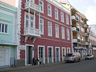
Praia is the capital and largest city of Cape Verde. Located on the southern coast of Santiago island, within the Sotavento Islands group, the city is the seat of the Praia Municipality. Praia is the political, economic and cultural center of Cape Verde.

Pollok is a large housing estate on the south-western side of the city of Glasgow, Scotland. The estate was built either side of World War II to house families from the overcrowded inner city. Housing 30,000 at its peak, its population has since declined due to the replacement of substandard housing with lower-density accommodation. As of 2021, the population was recorded at 81,951 people.
Bergvliet is a suburb of Cape Town, South Africa. Bergvliet, which means "Mountain Streamlet" in Afrikaans, is bordered by Retreat, Meadowridge, Tokai, and Heathfield.
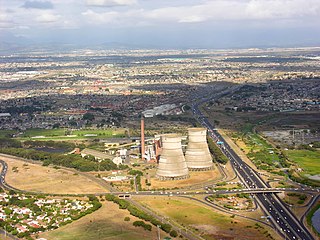
Athlone is a suburb of Cape Town located to the east of the city centre on the Cape Flats, south of the N2 highway. Two of the suburb's main landmarks are Athlone Stadium and the decommissioned coal-burning Athlone Power Station. Athlone is mainly residential and is served by a railway station of the same name. It however includes industrial and commercial zones. There are many "sub-areas" within Athlone, including Gatesville, Rylands, Belgravia Estate, Bridgetown and Hazendal. Colloquially other areas around Athlone are also often included in the greater Athlone area even though the City of Cape Town might classify them as separate neighborhoods such as Rondebosch East, Crawford, and Manenberg.

Tamboerskloof is a neighbourhood and suburb of Cape Town, South Africa. It lies on the slopes of Lion's Head and Signal Hill, adjacent to the neighbourhoods of Gardens and Bo-Kaap. Tamboerskloof is one of the contiguous group of neighbourhoods referred to as the City Bowl.

Mitchells Plain is a large census designated sub-place located within the City of Cape Town, Western Cape, South Africa and situated about 28 km (17 mi) from the Cape Town city centre. It is one of South Africa's largest residential areas and contains multiple smaller suburbs. It is located on the Cape Flats on the False Bay coast between Muizenberg and Khayelitsha. Conceived of as a "model suburb" by the apartheid government, it was built during the 1970s to provide housing for Coloured victims of forced removal due to the implementation of the Group Areas Act.

The Southern Suburbs are a group of Anglophone suburbs in Cape Town, Western Cape, South Africa. This group includes, among others, Observatory, Mowbray, Pinelands, Rosebank, Rondebosch, Rondebosch East, Newlands, Claremont, Lansdowne, Kenilworth, Bishopscourt, Constantia, Wynberg, Ottery, Plumstead, Diep River, Bergvliet and Tokai. The area is also commonly referred to as the Cape Peninsula, often including the towns further South such as Fish Hoek.

The Africa Muslim Party (AMP) is a South African Muslim political party. It was founded in 1994, with Gulam Sabdia as Chairman and Imtiaz Suleman as national leader, and competed in the 1994 elections, winning no seats. It competed in the 1999 elections, but only in Western Cape province, achieving 9,513 votes and no seats; the next year, the AMP competed in elections for Cape Town metropolitan area and received 2 seats in the local legislature. The AMP competed again for the Cape Town Metro council in 2006, gaining 3 seats. After the 2006 local government elections, it joined the multi-party coalition led by Democratic Alliance) which supported the mayoral government of the DA's Helen Zille. Its participation in the coalition was short-lived, and it was expelled in January 2007 when it was revealed that AMP councillor Badih Chaaban tried to make a coalition deal with the African National Congress (ANC) in which Chaaban would become the mayor in return for toppling the DA-led coalition. This plot had failed when the Independent Democrats (ID) joined the multi-party coalition and bolstered Zille's position.

Nyanga is a township in the Western Cape, South Africa. Its name in Xhosa means "moon" and it is one of the oldest black townships in Cape Town. It was established as a result of the migrant labour system. In 1948 black migrants were forced to settle in Nyanga as Langa had become too small. Nyanga was one of the poorest places in Cape Town and is still one of the most dangerous parts of Cape Town. In 2001 its unemployment rate was estimated at being approximately 56% and HIV/AIDS is a huge community issue.

Green Point is an affluent suburb on the Atlantic Seaboard of Cape Town, South Africa located to the north west of the central business district. It is home to Cape Town Stadium, a major sporting venue that was built for the 2010 FIFA World Cup. Sea Point promenade runs through the suburb, connecting it to Three Anchor Bay and Sea Point, a popular Jewish neighbourhood. Somerset Road forms the main thoroughfare lined by restaurants, cafés, delis, boutiques and nightclubs.
Grassy Park is a suburb of the City of Cape Town in the Western Cape Province of South Africa.

Ottery is a suburb in Cape Town, South Africa. It is on the edge of the Southern Suburbs. The Youngsfield Military Base, Royal Cape Golf Club and Cape Town's 'official' China Town are located in the suburb. Every year the Youngsfield Military Base in Ottery hosts the Cape Argus Junior Cycle Tour on 12 March. The name was derived off the Otter sanctuary which was opened here in the early 1900's, but was closed down as the neighbourhood rapidly expanded later in the century.
Walmer Estate is a suburb of Cape Town in the Western Cape province of South Africa. It lies at the foot of Table Mountain and is bordered to the south by Table Mountain National Park, to the north-east by Woodstock and to the west by Zonnebloem. It covers an area of 0.47 km2.
Harfield Village, also known as Lower Claremont, is a neighbourhood in the south of Cape Town. It is located between the suburbs of Kenilworth and Claremont, Cape Town. The Arderne Gardens are located to the area's immediate north on the other side of Harfield Station. Although it is typically regarded as being part of Claremont, parts of the village overlap with areas commonly regarded as being parts of lower Kenilworth.

Forestvale is a rural locality in the Maranoa Region, Queensland, Australia. In the 2021 census, Forestvale had a population of 47 people.
Portland is a neighborhood in the Mitchells Plain urban area of the City of Cape Town in the Western Cape province of South Africa. It is just west of the Mitchells Plain Town Centre.

Lentegeur is a neighbourhood in the north eastern section of the Mitchells Plain urban area of the City of Cape Town in the Western Cape province of South Africa. The 400 bed Mitchells Plain Hospital, one of Cape Town's larger hospitals, is located in the neighbourhood. The Lentegeur Sports Grounds dominate the central area of the neighbourhood.
Mandalay is a neighbourhood in the northeastern corner of the Mitchells Plain urban area of the City of Cape Town in the Western Cape province of South Africa.

Westridge is a neighbourhood located within the Mitchells Plain urban area of the City of Cape Town in the Western Cape province of South Africa. It is located in the western part of the Mitchells Plain area. The Westridge Gardens, which hosts several indigenous Cape Flats fynbos species, is an important large public park in the area located in the north of Westridge.


