The Cape Flats is an expansive, low-lying, flat area situated to the southeast of the central business district of Cape Town. The Cape Flats is also the name of an administrative region of the City of Cape Town, which lies within the larger geographical area.

The Rondevlei Nature Reserve is located in Grassy Park, Zeekoevlei and Lavenderhill, suburbs of Cape Town, South Africa. The bird sanctuary covers approximately 290 hectares of mostly permanent wetland and consists of a single large brackish lagoon. The nature reserve is among the most important wetlands for birds in South Africa despite being situated directly alongside the Zeekoevlei. A number of islands on the vlei act as vital breeding sites. Rondevlei is home to about 230 bird species, a variety of small mammals and reptiles like caracal, porcupine, Cape fox, grysbuck, steenbuck and mongoose, as well as a hippopotamus population which was re-introduced in 1981 as a means to control an alien grass species from South America, which had covered the shoreline and was threatening to engulf the vlei itself. It boasts unusual and threatened ecosystems like strandveld, sand plains fynbos, Cape lowland wetland vegetation and indigenous coastal fynbos vegetation with unique plants found nowhere else in the world.

The Cape Floral Region is a floristic region located near the southern tip of South Africa. It is the only floristic region of the Cape Floristic Kingdom, and includes only one floristic province, known as the Cape Floristic Province.

Helderberg refers to a planning district of the City of Cape Town metropolitan municipality, the mountain after which it is named, a wine-producing area in the Western Cape province of South Africa, or a small census area in Somerset West.

The Kogelberg is a range of mountains along the False Bay coast in the Western Cape of South Africa. They form part of the Cape Fold Belt, starting south of the Elgin valley and forming a steep coastal range as far as Kleinmond.
The Milnerton Racecourse Nature Reserve is a lowland conservation area located in the City of Cape Town, South Africa.
The Diep River Fynbos Corridor is a nature reserve located in the Blaauwberg region of Cape Town, South Africa. It forms part of the larger Table Bay Nature Reserve, which was established in June 2012.
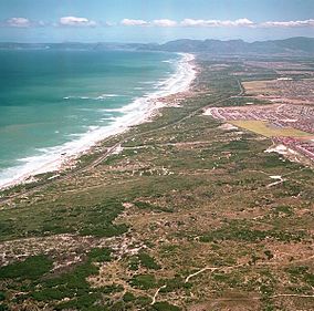
Cape Flats Dune Strandveld is an endangered vegetation type. This is a unique type of Cape Strandveld that is endemic to the coastal areas around Cape Town, including the Cape Flats.

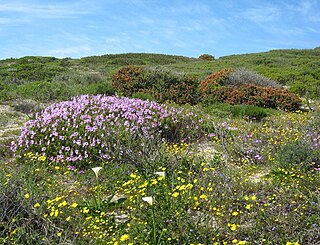
Cape Flats Sand Fynbos (CFSF), previously known as Sand Plain Fynbos, is a critically endangered vegetation type that occurs only within the city of Cape Town. Less than 1% of this unique lowland fynbos vegetation is conserved.
Zandvlei Estuary Nature Reserve is a 300-hectare (740-acre) nature reserve and recreational area located in Muizenberg near Cape Town, South Africa.

Edith Stephens Wetland Park is a nature reserve for wetlands and fynbos, located in the city of Cape Town, South Africa.
Witzands Aquifer Nature Reserve is a 3,000-hectare (7,400-acre) protected natural area in Cape Town, South Africa, located on the city's northern outskirts. This reserve protects an important part of Cape Town's natural and cultural heritage, including the Atlantis Aquifer. It is adjacent to the Koeberg Nature Reserve.

Durbanville Nature Reserve is a 6-hectare (15-acre) piece of protected land, located next to the Hollywoodbets Durbanville Racecourse in the Western Cape, South Africa.

Harmony Flats Nature Reserve is a 9-hectare (22-acre) piece of protected land, located between Strand and Gordon's Bay, South Africa. It protects a surviving fragment of critically endangered Lourensford Alluvium Fynbos vegetation.

Blaauwberg Nature Reserve was proclaimed a local and provincial nature reserve in 2007. The reserve has views down fynbos slopes, across the city, to seven kilometres of rocky and sandy coastline and the ocean and beyond. The reserve presents itself as one of the few viewpoints in the world from where you can see two proclaimed world heritage sites, namely Table Mountain and Robben Island.

Macassar Dunes Conservation Area is a 1,116-hectare (2,760-acre) coastal nature reserve in Macassar, within the City of Cape Town, South Africa.
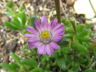
Lampranthus tenuifolius, the narrow-leaf brightfig, is a critically endangered species of succulent plant that is endemic to the Cape Flats Dune Strandveld around Cape Town, South Africa.
The Helderberg Marine Protected Area is a small marine conservation area on the north-eastern side of False Bay in the Western Cape province of South Africa, It lies between the mouths of the Lourens River in the Strand, and the Eerste River in Macassar.