Longships Lighthouse is an active 19th-century lighthouse about 1.25 mi (2.0 km) off the coast of Land's End in Cornwall, England. It is the second lighthouse to be built on Carn Bras, the highest of the Longships islets which rises 39 feet (12 m) above high water level. In 1988 the lighthouse was automated, and the keepers withdrawn. It is now remotely monitored from the Trinity House Operations & Planning Centre in Harwich, Essex.
The Eddystone Lighthouse is a lighthouse on the Eddystone Rocks, 9 statute miles (14 km) south of Rame Head in Cornwall, England. The rocks are submerged below the surface of the sea and are composed of Precambrian gneiss.
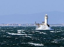
Coquet Island is a small island of about 6 hectares, situated 1.2 kilometres (0.75 mi) off Amble on the Northumberland coast, northeast England. It is included in the civil parish of Hauxley.

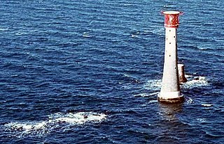
The Bishop Rock is a skerry off the British coast in the northern Atlantic Ocean known for its lighthouse. It is in the westernmost part of the Isles of Scilly, an archipelago 45 kilometres off the southwestern tip of the Cornish peninsula of Great Britain. The Guinness Book of Records lists it as the world's smallest island with a building on it.

St Anthony's Lighthouse is the lighthouse at St Anthony Head, on the eastern side of the entrance to Falmouth harbour, Cornwall, UK. The harbour is also known as Carrick Roads and is one of the largest natural harbours in the world.

The Lizard Lighthouse is a lighthouse at Lizard Point, Cornwall, England, built to guide vessels passing through the English Channel. It was often the welcoming beacon to persons returning to England, where on a clear night, the reflected light could be seen 100 mi (160 km) away.

South Foreland Lighthouses are a pair of Victorian lighthouses on the South Foreland in St. Margaret's Bay, Dover, Kent, England, used to warn ships approaching the nearby Goodwin Sands. There has been a pair of lighthouses at South Foreland since at least the 1630s. Even after the decommissioning of the Lower Lighthouse the pair continued to be used as leading marks, with Admiralty charts into the 20th century indicating that the 'Lighthouses in line lead south of the Goodwin Sands'.

Hurst Point Lighthouse is located at Hurst Point in the English county of Hampshire, and guides vessels through the western approaches to the Solent.

Wolf Rock Lighthouse is on the Wolf Rock, a single rock located 18 nautical miles east of St Mary's, Isles of Scilly and 8 nautical miles southwest of Land's End, in Cornwall, England, United Kingdom. The fissures in the rock are said to produce a howling sound in gales, hence the name.
The High lighthouse or pillar lighthouse is one of three lighthouses in Burnham-on-Sea, Somerset, England. A Grade II listed building, it is no longer functional as a lighthouse and has been converted for use as a private dwelling.

Norah Head Light is an active lighthouse located at Norah Head, a headland on the Central Coast, New South Wales, Australia, close to Toukley. It is the last lighthouse of the James Barnet style to be built, and the last staffed lighthouse constructed in New South Wales.

Completed in 1849, the original 20-metre (66 ft) Wadjemup Lighthouse was Western Australia's first stone lighthouse and was built to provide a safer sailing passage for ships to Fremantle Port and the Swan River Colony.
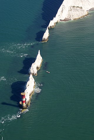
The Needles Lighthouse is an active 19th century lighthouse on the outermost of the chalk rocks at The Needles on the Isle of Wight in the United Kingdom, near sea level. Designed by James Walker, for Trinity House at a cost of £20,000, it was completed in 1859 from granite blocks. It stands 33.25 metres (109.1 ft) high and is a circular tower with straight sides. It replaced an earlier light tower on top of a cliff overhanging Scratchell's Bay, which was first lit on 29 September 1786.

The Europa Point Lighthouse, also referred to as the Trinity Lighthouse at Europa Point and the Victoria Tower or La Farola in Llanito, is a lighthouse at Europa Point, on the southeastern tip of the British Overseas Territory of Gibraltar, on the southern end of the Iberian Peninsula, at the entrance to the Mediterranean Sea.

Whitby Lighthouse is a lighthouse operated by Trinity House. It is on Ling Hill, on the coast to the southeast of Whitby, beyond Saltwick Bay. To distinguish it from the two lighthouses in Whitby itself it is sometimes known as Whitby High lighthouse

Lowestoft Lighthouse is a lighthouse operated by Trinity House located to the north of the centre of Lowestoft in the English county of Suffolk. It stands on the North Sea coast close to Ness Point, the most easterly point in the United Kingdom. It acts as a warning light for shipping passing along the east coast and is the most easterly lighthouse in the UK.

Peninnis Lighthouse is situated on Peninnis Head, St Mary's, Isles of Scilly.

The Dog Island Lighthouse on Dog Island in Foveaux Strait is New Zealand's tallest lighthouse, and one of its oldest. It is notable for its masonry construction, and is a work example by an engineer who was prominent at the time. The lighthouse employed the first revolving beam in New Zealand, and the unique original light apparatus was in use for 60 years. Dog Island Lighthouse is one of the most distinct lighthouses in New Zealand, with only two others having stripes painted on them for better visibility at daytime. The lighthouse is registered by Heritage New Zealand as a Category I structure, and the adjacent lighthouse keepers cottage has a Category II registration. Originally operated by three lighthouse keepers, the structure has since 1989 been remote controlled from Maritime New Zealand's Wellington office, with Dog Island since having been uninhabited. Dog Island Lighthouse has twice featured on New Zealand stamps.
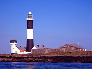
Mew Island Lighthouse is an active lighthouse within the Copeland Islands of County Down in Northern Ireland. The current 19th-century tower is the most recent in a series of lighthouses that have been built in the islands, which have helped to guide shipping around the archipelago and into Belfast Lough.

The isle of Lundy has three lighthouses: a pair of active lights built in 1897 and a preserved older lighthouse dating from 1819.