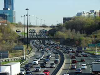
King's Highway 404, also known as Highway 404 and colloquially as the 404, is a 400-series highway in the Canadian province of Ontario. A continuation of the municipal Don Valley Parkway (DVP) north of Highway 401, it connects Toronto with East Gwillimbury. The 50.1-kilometre (31.1 mi) controlled-access freeway also connects with Highway 407 in Markham, which formed the northeastern ring road of the Greater Toronto Area until the opening of Highway 412 in 2016. Highway 404 provides access to the eastern edge of Richmond Hill, Aurora and Newmarket and the western edge of Whitchurch-Stouffville, in addition to the southern edge of Keswick.
South Gippsland Freeway is a short freeway linking Dandenong in Melbourne's south–east to other south–eastern destinations, including the Mornington Peninsula and the Gippsland region. The freeway bears the designation M420.
King's Highway 403, or simply Highway 403, is a 400-series highway in the Canadian province of Ontario that travels between Woodstock and Mississauga, branching off from and reuniting with Highway 401 at both ends and travelling south of it through Hamilton and Mississauga. It is concurrent with the Queen Elizabeth Way (QEW) for 22 km (14 mi) from Burlington to Oakville. The Highway 403 designation was first applied in 1963 to a short stub of freeway branching off the QEW, and the entire route was completed on August 15, 1997, when the section from Brantford to the then-still independent Town of Ancaster was opened to traffic. The section of Highway 403 between Woodstock and Burlington was formally dedicated as the Alexander Graham Bell Parkway on April 27, 2016, in honour of Alexander Graham Bell.

The N1 is a national route in South Africa that runs from Cape Town through Bloemfontein, Johannesburg, Pretoria and Polokwane to Beit Bridge on the border with Zimbabwe. It forms the first section of the famed Cape to Cairo Road.
King's Highway 410, also known as Highway 410 and colloquially as the four-ten, is a 400-series highway in the Canadian province of Ontario that connects Highways 401 and 403 to Brampton. North of Brampton, the commuter freeway ends and the route becomes Highway 10, which continues north through Caledon as a four-lane undivided highway. The route is patrolled by the Ontario Provincial Police and has a speed limit of 100 km/h (62 mph).

.
The Mitchell Freeway is a 41.5-kilometre-long (25.8 mi) freeway in the northern suburbs of Perth, Western Australia, linking central Perth with the city of Joondalup. It is the northern section of State Route 2, which continues south as Kwinana Freeway and Forrest Highway. Along its length are interchanges with several major roads, including the Graham Farmer Freeway and Reid Highway. The southern terminus of the Mitchell Freeway is at the Narrows Bridge, which crosses the Swan River, and the northern terminus is at Romeo Road in Alkimos.

The N2 is a national route in South Africa that runs from Cape Town through George, Gqeberha, East London, Mthatha, Port Shepstone and Durban to Ermelo. It is the main highway along the Indian Ocean coast of the country. Its current length of 2,255 kilometres (1,401 mi) makes it the longest numbered route in South Africa.

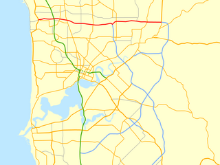
Reid Highway is a 23-kilometre (14 mi) east-west highway and partial freeway in the northern suburbs of Perth, Western Australia, linking North Beach with Middle Swan. As part of State Route 3, it forms half of Perth's outer ring road along with Roe Highway, which it joins onto at its eastern terminus.

The M5 is an expressway in the City of Cape Town Metropolitan Municipality, South Africa. It connects Milnerton on the Western Seaboard in the north to Muizenberg in the south, and crosses both the N1 and the N2. For part of its length, from the N1 interchange to Plumstead, it is a limited-access freeway (motorway). From Mowbray to Muizenberg it is parallel to the M4 Main Road.

The M3 is an expressway in Cape Town, South Africa, connecting the upper part of the City Bowl to the Southern Suburbs and ending in Tokai. For most of its route it parallels - though further to the south and west - the M4, which was the original road connecting central Cape Town with the settlements to the south.

The N12 is a national route in South Africa which runs from George through Beaufort West, Kimberley, Klerksdorp and Johannesburg to eMalahleni.

The N4 is a national route in South Africa that runs from Skilpadshek on the Botswana border, past Rustenburg, Pretoria, eMalahleni and Mbombela, to Komatipoort on the Mozambique border. The entire route is a toll road.

Mowbray is one of the Southern Suburbs of Cape Town, South Africa and lies on the slopes of Devil's Peak. Mowbray is at a junction of several major Cape Town highways and has an important multi-modal public transport interchange at Mowbray railway station. Its original name was Driekoppen.

The N17 is a national route in South Africa which runs from Johannesburg to Oshoek (Ngwenya) on the border with Eswatini. It passes through Springs, Bethal and Ermelo.

A wide variety of road signs are displayed in the People's Republic of China.

Terminology related to road transport—the transport of passengers or goods on paved routes between places—is diverse, with variation between dialects of English. There may also be regional differences within a single country, and some terms differ based on the side of the road traffic drives on. This glossary is an alphabetical listing of road transport terms.

The M4 is a long metropolitan route in the City of Cape Town Metropolitan Municipality in South Africa. It connects the Cape Town CBD with the Cape of Good Hope via Wynberg, Muizenberg and Fish Hoek. Originally, it was the main route connecting the Cape Town CBD with the Southern Suburbs and is thus named Main Road for much of its length. From the CBD to Kirstenhof, it is parallel to the M3 Freeway.
The M5 is a long metropolitan route in the eThekwini Metropolitan Municipality, South Africa. It starts in KwaMashu in the north-western townships of Durban. It passes through the townships of Newlands East, Newlands West, Ntuzuma and KwaDabeka. It then passes through the industrial town of New Germany and the leafy towns of Pinetown and Queensburgh before entering Durban and ending in the Umbilo industrial area.


