
Berg wind (from Afrikaans berg "mountain" + wind "wind", i.e. a mountain wind) is the South African name for a katabatic wind: a hot dry wind blowing down the Great Escarpment from the high central plateau to the coast.
Berg wind (from Afrikaans berg "mountain" + wind "wind", i.e. a mountain wind) is the South African name for a katabatic wind: a hot dry wind blowing down the Great Escarpment from the high central plateau to the coast.
When the air that has been heated on the extensive central plateau flows down the escarpment to the coast it undergoes further warming by adiabatic processes. This accounts for the hot and dry properties of these off-shore winds, wherever they occur along South Africa's coastline. [1] [2]
Although berg winds are often called a Föhn winds, this is probably a misnomer, as Föhn winds are rain shadow winds that result from air moving over a mountain range, resulting in precipitation on the windward side. This releases latent heat into the atmosphere which is then warmed still further as the air descends on the leeward side (e.g., the Chinook or the original Föhn). [2] [3] Berg winds do not originate in precipitation, but in the mostly dry, often arid central plateau of Southern Africa. On the other hand, katabatic winds are technically drainage winds, that carry high density, usually cold air from a high elevation down a slope under the force of gravity. [3] These are thus "fall winds", which occur most typically down the coastal ice slopes of Antarctica and Greenland. Berg winds blow off the African escarpment in response to large scale weather systems in the South Atlantic Ocean, the African interior, and the Southern Indian Ocean.

Berg winds are usually accompanied by coastal lows. [3] These coastal lows owe their existence to the configuration of the plateau, escarpment and coastal plain (see diagram on the right, above), in that they are confined to the coastal areas, always below the escarpment. Though they can arise almost anywhere along the coast, they often first appear on the west coast, or even on the Namibian coast. They are then always propagated counter-clockwise along South Africa's coastline at between 30 and 60 kilometres per hour (19 and 37 mph), from the west coast southwards to the Cape Peninsula and then eastward along the south coast, and finally north-eastward along the KwaZulu-Natal coastline, to finally dissipate north of Durban, due to the divergence of the coastline from the plateau which disappears altogether in the vicinity of the Limpopo valley. [4] There is always a hot off-shore berg wind ahead of a coastal low, which can blow for several days or for only for a few hours. This is then followed by cool onshore winds which bring low cloud, fog or drizzle to the region, but may, on occasions, produce substantial precipitation when coupled to an approaching cold front. [3]
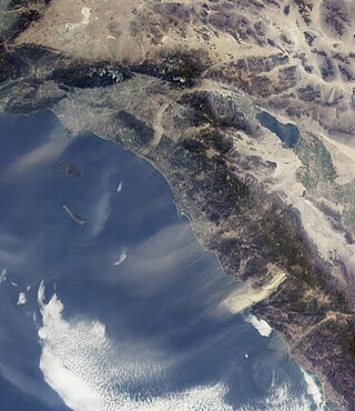
Coastal lows are a common feature of the coastal weather in South Africa with an average of about five lows of varying intensities passing through Port Elizabeth per month. [4] They are shallow (not more than 1,000 to 1,500 metres (3,300 to 4,900 ft) deep), mesoscale (medium-sized) systems that are generally not more than 100 to 200 kilometres (62 to 124 mi) across, trapped on the coastal plain by the escarpment on the inland side, Coriolis effects on the oceanic side, and an inversion layer above. The pressure minima of these systems lie just off-shore. In the south-west corner of the country the coastal lows are bounded on the inland side by the Cape Fold Mountains, [4] which tend to have a higher elevation than the escarpment, and form an almost continuous 1,000 kilometres (620 mi) mountain barrier running parallel to the coast from the Cederberg, 300 kilometres (190 mi) to the north of Cape Town, to Cape Hangklip on the east side of False Bay and then eastwards for 700 kilometres (430 mi) to Port Elizabeth, where they eventually peter out (see the map above).

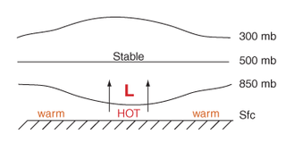
Coastal lows are initiated by the interaction of large scale weather systems such as the quasi-permanent South Atlantic and South Indian Ocean Anticyclones (high-pressure systems), the cold fronts that approach the subcontinent from the South Atlantic Ocean, as well as the pressure systems on the plateau, causing air that has been warmed on the plateau by 2–3 days of sunny weather to flow down the Great Escarpment on to the coastal plain either on the west or south coasts of the country (i.e. causing a berg wind). The descending air warms up adiabatically, heating up the coastal plain, while, at the same time, causing an off-shore wind which blows the surface water away from the land to be replaced by cold water which wells up from the depths. This upwelling of cold subsurface water from the ocean increases the ocean-land temperature difference, causing an on-shore wind. [3]
The on-shore airflow is strengthened by the fact that the berg wind is not only hot, but it is also “stretched” vertically due to the sudden lowering of the floor over which it moves below the escarpment. Its low density, therefore, lowers the atmospheric pressure on the coast. [4] This low-pressure area caused by the berg wind draws the dense moist maritime air onshore to the right of the off-shore berg wind. Shear forces between these on- and off-shore winds on the right-hand side of the berg wind tend to cause clockwise (or cyclonic) rotation of the air in this region. In addition, on reaching the escarpment the maritime air curves to the right round the low-pressure zone due to Coriolis forces (in the southern hemisphere) accentuating the cyclonic circulation of the "coastal low". [2] [3] The entire system is capped by an inversion consisting of a layer of warm air that has moved horizontally off the plateau at the level of the upper edge of the escarpment. [4] This inversion layer prevents the upwardly spiraling cyclonic air of the coastal low from rising above 1000–1500 m, thus preventing it from causing significant precipitation. [3]
Along the south coast the passage of a coastal low is typically preceded by a north-easterly wind driven by the South Indian Ocean Anticyclone. The wind then backs quickly through northerly to north-westerly as its temperature rises. This is the berg wind phase of the coastal low. The wind then changes abruptly to a strong, cold, south or south-westerly wind (called a “buster” if the change in wind speed is greater than 35 km/h). The buster coincides with the passage of the pressure minimum. The onshore wind gradually diminishes in intensity during the course of about a day, and is associated with cloudy, misty or drizzly weather. [3] [4]
Because of the often abrupt changes in horizontal and vertical wind speeds and direction that can occur within these small weather systems they represent a significant hazard to aircraft on landing and taking off. During the climb-out and approach phases of flight, aircraft airspeed and height are near critical values, thus rendering the aircraft especially susceptible to the adverse effects of these wind shears. [4]
The Atlantic cold fronts that move into and across the subcontinent, especially during the cooler months of the year, are frequently associated, the day before, by a coastal low that moves ahead of the front. Under these circumstances the southerly or south-westerly onshore wind of the coastal low gradually diminishes in intensity over the course of 12–20 hours, when it is replaced by a westerly wind (which may temporarily reach buster proportions) and a further drop in temperature accompanied by rain, indicative of the passage of the cold front. [3] Thus, particularly in Cape Town, an obvious berg wind is generally regarded as a harbinger of cold, wet weather.
Coastal lows are orographically trapped weather systems that also occur in other parts of the world, where there are mountain ranges between 1,000–4,000 kilometres (620–2,490 mi) in length. Thus they occur along the coast of Chile, eastern Australia and the west coast of North America, as well as on the eastern side of the Appalachian Mountains of the United States. In each of these cases the weather systems are trapped vertically by stable stratifications, and laterally by Coriolis effects against the mountains. [4] However, only the South African and the South American coastal disturbances are “coastal lows”; the remainder are generally produced by coastal ridging. [4]

At 824,292 km2 (318,261 sq mi), Namibia is the world's thirty-fourth largest country. After Mongolia, Namibia is the second least densely populated country in the world. Namibia got its name from the Namib desert that stretches along the coast of the Atlantic. It is also known for its wildlife.

The Great Dividing Range, also known as the East Australian Cordillera or the Eastern Highlands, is a cordillera system in eastern Australia consisting of an expansive collection of mountain ranges, plateaus and rolling hills. It runs roughly parallel to the east coast of Australia and forms the fifth-longest land-based mountain chain in the world, and the longest entirely within a single country. It is mainland Australia's most substantial topographic feature and serves as the definitive watershed for the river systems in eastern Australia, hence the name.

South Africa occupies the southern tip of Africa, its coastline stretching more than 2,850 kilometres from the desert border with Namibia on the Atlantic (western) coast southwards around the tip of Africa and then northeast to the border with Mozambique on the Indian (eastern) coast. The low-lying coastal zone is narrow for much of that distance, soon giving way to a mountainous escarpment that separates the coast from the high inland plateau. In some places, notably the province of KwaZulu-Natal in the east, a greater distance separates the coast from the escarpment. Although much of the country is classified as semi-arid, it has considerable variation in climate as well as topography. The total land area is 1,220,813 km2 (471,359 sq mi). It has the 23rd largest Exclusive Economic Zone of 1,535,538 km2 (592,875 sq mi).
The Santa Ana winds, also sometimes called the devil winds, are strong, extremely dry downslope winds that originate inland and affect coastal Southern California and northern Baja California. They originate from cool, dry high-pressure air masses in the Great Basin.
A katabatic wind carries high-density air from a higher elevation down a slope under the force of gravity. Such winds are sometimes also called fall winds; the spelling catabatic winds is also used. Katabatic winds can rush down elevated slopes at hurricane speeds, but most are not that intense and many are 10 knots or less.

A Foehn, or Föhn, is a type of dry, relatively warm downslope wind that occurs in the lee of a mountain range. It is a rain shadow wind that results from the subsequent adiabatic warming of air that has dropped most of its moisture on windward slopes. As a consequence of the different adiabatic lapse rates of moist and dry air, the air on the leeward slopes becomes warmer than equivalent elevations on the windward slopes.

Orographic lift occurs when an air mass is forced from a low elevation to a higher elevation as it moves over rising terrain. As the air mass gains altitude it quickly cools down adiabatically, which can raise the relative humidity to 100% and create clouds and, under the right conditions, precipitation.

A nor'easter is a large-scale extratropical cyclone in the western North Atlantic Ocean. The name derives from the direction of the winds that blow from the northeast. Typically, such storms originate as a low-pressure area that forms within 100 miles (160 km) of the shore between North Carolina and Massachusetts. The precipitation pattern is similar to that of other extratropical storms, although nor'easters are usually accompanied by heavy rain or snow, and can cause severe coastal flooding, coastal erosion, hurricane-force winds, or blizzard conditions. They tend to develop most often and most powerfully between the months of November and March, because of the difference in temperature between the cold polar air mass coming down from central Canada and the warm ocean waters off the upper East Coast. The susceptible regions—the upper north Atlantic coast of the United States and the Atlantic Provinces of Canada—are generally impacted by nor'easters a few times each winter.

A rain shadow is an area of significantly reduced rainfall behind a mountainous region, on the side facing away from prevailing winds, known as its leeward side.

Atmospheric circulation is the large-scale movement of air and together with ocean circulation is the means by which thermal energy is redistributed on the surface of the Earth. The Earth's atmospheric circulation varies from year to year, but the large-scale structure of its circulation remains fairly constant. The smaller-scale weather systems – mid-latitude depressions, or tropical convective cells – occur chaotically, and long-range weather predictions of those cannot be made beyond ten days in practice, or a month in theory.

In meteorology, a low-pressure area, low area or low is a region where the atmospheric pressure is lower than that of surrounding locations. Low-pressure areas are commonly associated with inclement weather, while high-pressure areas are associated with lighter winds and clear skies. Winds circle anti-clockwise around lows in the northern hemisphere, and clockwise in the southern hemisphere, due to opposing Coriolis forces. Low-pressure systems form under areas of wind divergence that occur in the upper levels of the atmosphere (aloft). The formation process of a low-pressure area is known as cyclogenesis. In meteorology, atmospheric divergence aloft occurs in two kinds of places:

Chinook winds, or simply Chinooks, are two types of prevailing warm, generally westerly winds in western North America: Coastal Chinooks and interior Chinooks. The coastal Chinooks are persistent seasonal, wet, southwesterly winds blowing in from the ocean. The interior Chinooks are occasional warm, dry föhn winds blowing down the eastern sides of interior mountain ranges. The coastal Chinooks were the original term, used along the northwest coast, and the term in the interior of North America is later and derives from the coastal term.
In meteorology, prevailing wind in a region of the Earth's surface is a surface wind that blows predominantly from a particular direction. The dominant winds are the trends in direction of wind with the highest speed over a particular point on the Earth's surface at any given time. A region's prevailing and dominant winds are the result of global patterns of movement in the Earth's atmosphere. In general, winds are predominantly easterly at low latitudes globally. In the mid-latitudes, westerly winds are dominant, and their strength is largely determined by the polar cyclone. In areas where winds tend to be light, the sea breeze/land breeze cycle is the most important cause of the prevailing wind; in areas which have variable terrain, mountain and valley breezes dominate the wind pattern. Highly elevated surfaces can induce a thermal low, which then augments the environmental wind flow.

June Gloom is a mainly Southern California term for a weather pattern that results in cloudy, overcast skies with cool temperatures during the late spring and early summer. While it is most common in the month of June, it can occur in surrounding months, giving rise to other colloquialisms, such as “Graypril,” “May Gray,” “No-Sky July,” “Fogust”, and “Summer Bummer”. Low-altitude stratus clouds form over the cool water of the California Current, and spread overnight into the coastal regions of California.

The Fremantle Doctor, the Freo Doctor, or simply The Doctor, is the Western Australian vernacular term for the cooling afternoon sea breeze that occurs during summer months in south west coastal areas of Western Australia. The sea breeze occurs because of the major temperature difference between the land and sea.

The KwaZulu-Natal sardine run of southern Africa occurs from May through July when billions of sardines – or more specifically the Southern African pilchard Sardinops sagax – spawn in the cool waters of the Agulhas Bank and move northward along the east coast of South Africa. Their sheer numbers create a feeding frenzy along the coastline. The run, containing millions of individual sardines, occurs when a current of cold water heads north from the Agulhas Bank up to Mozambique where it then leaves the coastline and goes further east into the Fisherman are sometimes observed singing songs while hauling in the fishing nets in typical South African style. It is estimated that the sardine run is the biggest Biomass migration in terms of numbers.
Thermal lows, or heat lows, are non-frontal low-pressure areas that occur over the continents in the subtropics during the warm season, as the result of intense heating when compared to their surrounding environments. Thermal lows occur near the Sonoran Desert, on the Mexican plateau, in California's Great Central Valley, in the Sahara, in the Kalahari, over north-west Argentina, in South America, over the Kimberley region of north-west Australia, over the Iberian Peninsula, and over the Tibetan plateau.

The Monsoon of South Asia is among several geographically distributed global monsoons. It affects the Indian subcontinent, where it is one of the oldest and most anticipated weather phenomena and an economically important pattern every year from June through September, but it is only partly understood and notoriously difficult to predict. Several theories have been proposed to explain the origin, process, strength, variability, distribution, and general vagaries of the monsoon, but understanding and predictability are still evolving.

The southeast Australian foehn is a westerly foehn wind and a rain shadow effect that usually occurs on the coastal plain of southern New South Wales, and as well as in southeastern Victoria and eastern Tasmania, on the leeward side of the Great Dividing Range.