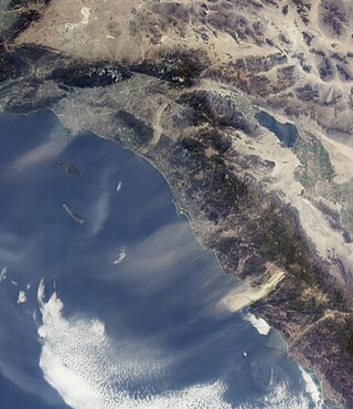
The Santa Ana winds, also sometimes called the devil winds, are strong, extremely dry downslope winds that originate inland and affect coastal Southern California and northern Baja California. They originate from cool, dry high-pressure air masses in the Great Basin.

A squall is a sudden, sharp increase in wind speed lasting minutes, as opposed to a wind gust, which lasts for only seconds. They are usually associated with active weather, such as rain showers, thunderstorms, or heavy snow. Squalls refer to the increase of the sustained winds over that time interval, as there may be higher gusts during a squall event. They usually occur in a region of strong sinking air or cooling in the mid-atmosphere. These force strong localized upward motions at the leading edge of the region of cooling, which then enhances local downward motions just in its wake.
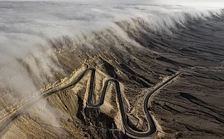
A katabatic wind carries high-density air from a higher elevation down a slope under the force of gravity. Such winds are sometimes also called fall winds; the spelling catabatic winds is also used. Katabatic winds can rush down elevated slopes at hurricane speeds, but most are not that intense and many are 10 knots or less.

A Foehn, or Föhn, is a type of dry, relatively warm downslope wind that occurs in the lee of a mountain range. It is a rain shadow wind that results from the subsequent adiabatic warming of air that has dropped most of its moisture on windward slopes. As a consequence of the different adiabatic lapse rates of moist and dry air, the air on the leeward slopes becomes warmer than equivalent elevations on the windward slopes.

Orographic lift occurs when an air mass is forced from a low elevation to a higher elevation as it moves over rising terrain. As the air mass gains altitude it quickly cools down adiabatically, which can raise the relative humidity to 100% and create clouds and, under the right conditions, precipitation.
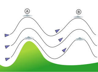
In meteorology, lee waves are atmospheric stationary waves. The most common form is mountain waves, which are atmospheric internal gravity waves. These were discovered in 1933 by two German glider pilots, Hans Deutschmann and Wolf Hirth, above the Giant Mountains. They are periodic changes of atmospheric pressure, temperature and orthometric height in a current of air caused by vertical displacement, for example orographic lift when the wind blows over a mountain or mountain range. They can also be caused by the surface wind blowing over an escarpment or plateau, or even by upper winds deflected over a thermal updraft or cloud street.

June Gloom is a mainly Southern California term for a weather pattern that results in cloudy, overcast skies with cool temperatures during the late spring and early summer. While it is most common in the month of June, it can occur in surrounding months, giving rise to other colloquialisms, such as “Graypril,” “May Gray,” “No-Sky July,” “Fogust”, and “Summer Bummer”. Low-altitude stratus clouds form over the cool water of the California Current, and spread overnight into the coastal regions of California.

A tropical wave, in and around the Atlantic Ocean, is a type of atmospheric trough, an elongated area of relatively low air pressure, oriented north to south, which moves from east to west across the tropics, causing areas of cloudiness and thunderstorms. Tropical waves form in the easterly flow along the equatorial side of the subtropical ridge or belt of high air pressure which lies north and south of the Intertropical Convergence Zone (ITCZ). Tropical waves are generally carried westward by the prevailing easterly winds along the tropics and subtropics near the equator. They can lead to the formation of tropical cyclones in the north Atlantic and northeastern Pacific basins. A tropical wave study is aided by Hovmöller diagrams, a graph of meteorological data.

The Berkeley Hills are a range of the Pacific Coast Ranges, and overlook the northeast side of the valley that encompasses San Francisco Bay. They were previously called the "Contra Costa Range/Hills", but with the establishment of Berkeley and the University of California, the current usage was applied by geographers and gazetteers.
The climate of San Diego, California is classified as a hot-summer Mediterranean climate. The basic climate features hot, sunny, and dry summers, and cooler, wetter winters. However, San Diego is much more arid than typical Mediterranean climates, and winters are still dry compared with most other zones with this type of climate. The climate at San Diego International Airport, the location for official weather reports for San Diego, as well as the climate at most beach areas, straddles the border between BSh and BSk due to the mild winters and cool summers in these locations.

San Francisco Bay is a multi-county American Viticultural Area (AVA) which is centered and surrounds the San Francisco Bay Area of Northern California. It was established on March 22, 1999 by the Bureau of Alcohol, Tobacco and Firearms (ATF), Treasury after evaluating the petition submitted by a consortium of nearly 75 growers and vintners led by Wente Bros. to establish the viticultural area known as "San Francisco Bay." It lies within the larger Central Coast viticultural area and includes San Francisco and counties encompassing the areas known as “South” and “East Bay.” This consists of Alameda, Contra Costa, Santa Clara, and San Mateo as well as portions of Santa Cruz and San Benito Counties. “North Bay” counties of Sonoma, Napa and Marin were excluded for they reside within the North Coast viticultural area with its distinct properties. ATF also concluded the established Santa Cruz Mountains viticultural area exhibits features and characteristics unique to its boundaries when compared to the surrounding areas, therefore, it was excluded from the "San Francisco Bay" viticultural area.
A sundowner is a northerly offshore wind in California along the southern Pacific slope of Santa Ynez Mountains, in communities along the Gaviota Coast and Santa Barbara towards but not including Ventura County.
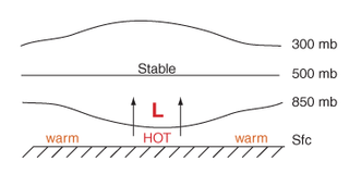
Thermal lows, or heat lows, are non-frontal low-pressure areas that occur over the continents in the subtropics during the warm season, as the result of intense heating when compared to their surrounding environments. Thermal lows occur near the Sonoran Desert, on the Mexican plateau, in California's Great Central Valley, in the Sahara, in the Kalahari, over north-west Argentina, in South America, over the Kimberley region of north-west Australia, over the Iberian peninsula, and over the Tibetan plateau.

The North American monsoon, variously known as the Southwest monsoon, the Mexican monsoon, the New Mexican monsoon, or the Arizona monsoon is a term for a pattern of pronounced increase in thunderstorms and rainfall over large areas of the southwestern United States and northwestern Mexico.
The 1978 Agoura-Malibu firestorm was a firestorm fueled by at least eight significant wildfires in the Los Angeles area on October 23, 1978. At around noon that day, an arsonist started a fire that eventually burned 25,000 acres (10,000 ha) from Cornell to Broad Beach in Malibu. The first fire alarm in Agoura was reported at 12:11 pm, and by 2:30 pm, the fire had reached the Pacific Ocean 13 miles (21 km) south in Malibu. It had been declared a Level 2 fire at 1:57 pm.
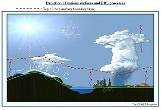
The alpine planetary boundary layer is the planetary boundary layer (PBL) associated with mountainous regions. Due to its high spatial and temporal variability, its behavior is more complex than over a flat terrain. The fast changing local wind system directly linked to topography and the variable land cover that goes from snow to vegetation have a significant effect on the growth of the PBL and make it much harder to predict.
The Sherpa Fire was a wildfire that burned in the Santa Ynez Mountains along the Gaviota Coast in the southwestern part of Santa Barbara County, California in June 2016. In a matter of hours the fire spread to over 1,400 acres (570 ha) as the fire was propelled by downslope sundowner winds. This offshore northerly wind contrasts with the more typical onshore flow and sent the fire down the canyons towards the ocean with gusts of over 35 miles per hour (56 km/h). The wildfire resulted in evacuations at two state beach campgrounds and some residences together with intermittent interruption of traffic on a state transportation route.

This glossary of meteorology is a list of terms and concepts relevant to meteorology and atmospheric science, their sub-disciplines, and related fields.

The southeast Australian foehn is a westerly foehn wind and a rain shadow effect that usually occurs on the coastal plain of southern New South Wales, and as well as in southeastern Victoria and eastern Tasmania, on the leeward side of the Great Dividing Range. Ranging from cool to hot, the effect occurs when westerly winds descend steeply from the Great Dividing Range onto the coastal slopes, whereby causing major adiabatic compression and a substantial loss of moisture.
