Related Research Articles
The Santa Ana winds, occasionally referred to as the devil winds, are strong, extremely dry katabatic winds that originate inland and affect coastal Southern California and northern Baja California. They originate from cool, dry high-pressure air masses in the Great Basin.

A Foehn, or Föhn, is a type of dry, relatively warm downslope wind in the lee of a mountain range. It is a rain shadow wind that results from the subsequent adiabatic warming of air that has dropped most of its moisture on windward slopes. As a consequence of the different adiabatic lapse rates of moist and dry air, the air on the leeward slopes becomes warmer than equivalent elevations on the windward slopes.
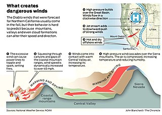
Diablo wind is a name that has been occasionally used for the hot, dry wind from the northeast that typically occurs in the San Francisco Bay Area of Northern California during the spring and fall.
A sea breeze or onshore breeze is any wind that blows from a large body of water toward or onto a landmass. By contrast, a land breeze or offshore breeze is any wind that blows from a landmass toward or onto a large body of water. Sea breezes and land breezes are both important factors in coastal regions' prevailing winds.
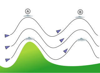
In meteorology, lee waves are atmospheric stationary waves. The most common form is mountain waves, which are atmospheric internal gravity waves. These were discovered in 1933 by two German glider pilots, Hans Deutschmann and Wolf Hirth, above the Giant Mountains. They are periodic changes of atmospheric pressure, temperature and orthometric height in a current of air caused by vertical displacement, for example orographic lift when the wind blows over a mountain or mountain range. They can also be caused by the surface wind blowing over an escarpment or plateau, or even by upper winds deflected over a thermal updraft or cloud street.

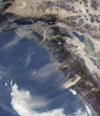
The Santa Ynez Mountains are a portion of the Transverse Ranges, part of the Pacific Coast Ranges of the west coast of North America. It is the westernmost range in the Transverse Ranges.
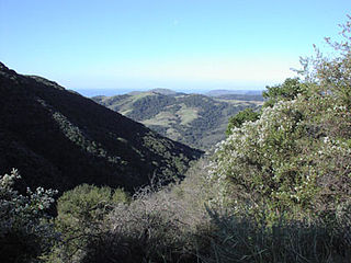
Gaviota State Park is a state park of California, United States. It is located in southern Santa Barbara County, California, about 33 miles (53 km) west of the city of Santa Barbara. One of three state parks along the Gaviota Coast, it extends from the Pacific coast to the crest of the Santa Ynez Mountains, and is adjacent to Los Padres National Forest. The 2,787-acre (1,128 ha) park was established in 1953.
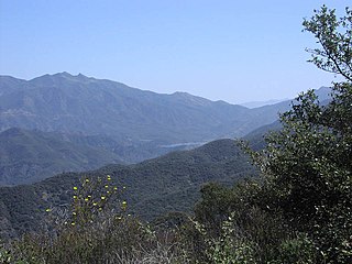
Los Padres National Forest is a United States national forest in southern and central California. Administered by the United States Forest Service, Los Padres includes most of the mountainous land along the California coast from Ventura to Monterey, extending inland. Elevations range from sea level to 8,847 feet (2,697 m).

Berg wind is the South African name for a katabatic wind: a hot dry wind blowing down the Great Escarpment from the high central plateau to the coast.

The climate of California varies widely from hot desert to alpine tundra, depending on latitude, elevation, and proximity to the Pacific Coast. California's coastal regions, the Sierra Nevada foothills, and much of the Central Valley have a Mediterranean climate, with warmer, drier weather in summer and cooler, wetter weather in winter. The influence of the ocean generally moderates temperature extremes, creating warmer winters and substantially cooler summers in coastal areas.
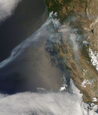
The 2008 wildfire season was one of California's most devastating in the 21st century. While 6,255 fires occurred, about two-thirds as many as in 2007, the total area burned— 1,593,690 acres —far exceeded that of previous years.
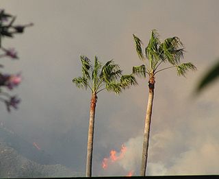
The Jesusita Fire was a wildfire that started on May 5, 2009, in the hills of Santa Barbara, California in the western United States. By the time the fire was contained on May 18 it had burned 8,733 acres (35.34 km2), destroyed 80 homes and damaged 15 more before being 100% contained. The cause of the fire was ultimately traced to local contractors who had left gas cans and hot equipment unattended in dry brush after clearing part of the Jesusita Trail using a weed wacker without any permits or the permission of the landowner.

The geography of southern California refers to the geography of southern California in the United States.
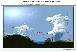
The alpine planetary boundary layer is the planetary boundary layer (PBL) associated with mountainous regions. Due to its high spatial and temporal variability, its behavior is more complex than over a flat terrain. The fast changing local wind system directly linked to topography and the variable land cover that goes from snow to vegetation have a significant effect on the growth of the PBL and make it much harder to predict.
The Painted Cave Fire was a devastating wildfire in June, 1990 that burned in the Santa Ynez Mountains and the city of Santa Barbara, within Santa Barbara County, California.
The Sherpa Fire was a wildfire that burned in the Santa Ynez Mountains along the Gaviota Coast in the southwestern part of Santa Barbara County, California in June 2016. In a matter of hours the fire spread to over 1,400 acres (570 ha) as the fire was propelled by downslope sundowner winds. This offshore northerly wind contrasts with the more typical onshore flow and sent the fire down the canyons towards the ocean with gusts of over 35 miles per hour (56 km/h). The wildfire resulted in evacuations at two state beach campgrounds and some residences together with intermittent interruption of traffic on a state transportation route.

The Whittier Fire was a wildfire in the Santa Ynez Mountains, south of Lake Cachuma, along Highway 154 in Santa Barbara County, California in the United States. The fire was reported on July 8, 2017, at 1:43 pm. Upon containment on July 28, the fire had burned a total of 18,430 acres (75 km2) and destroyed 16 homes.

The Maria Fire was a wildfire that burned the south of the community of Santa Paula in the area of Somis, California on the top of South Mountain in Ventura County. The fire ignited in the evening hours of Thursday, October 31, 2019, and consumed well over 4,000 acres (16 km2) within its first several hours of burning. Despite the aggressive initial attack by first responders, the fire exploded rapidly due to a strong Santa Ana wind event that was occurring in the area during its ignition.
The Matilija Fire was a major wildfire that burned nearly 220,000 acres (89,000 ha) in the Santa Barbara National Forest of Southern California, during the autumn of 1932. The fire is named for Matilija Creek, near the location from which it originated.
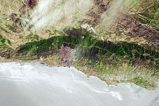
The Gaviota Coast in Santa Barbara County, California is a rural coastline along the Santa Barbara Channel roughly bounded by Goleta Point on the south and the north boundary of the county on the north. This last undeveloped stretch of Southern California coastline consists of dramatic bluffs, isolated beaches and terraced grasslands.
References
- ↑ Duginski, Paul (2022-03-12). "Why it's been so warm and windy in Southern California this winter". Los Angeles Times. Retrieved 2022-05-10.
- ↑ Ryan, G., and L. E. Burch, 1992. An analysis of sundowner winds: A California downslope wind event. Preprints, Sixth Conf. on Mountain Meteorology, Portland, Oregon, Amer. Meteor. Soc., 64–67.
- ↑ "UCSB Scientists to Study Sundowner Winds". edhat, Inc. 15 August 2019. Retrieved 13 January 2020.
- ↑ Serna, Joseph; Fernandez, Alexia (June 17, 2016). "Santa Barbara County declares state of emergency after wildfire grows to 4,000 acres overnight". Los Angeles Times . Retrieved 17 June 2016.
- ↑ Pine, Stephen J. (2016). California: A Fire Survey. Tucson: University of Arizona Press. p. 66. ISBN 978-0816532612.