
Cape Town is the legislative capital of South Africa. It is the country's oldest city and the seat of the Parliament of South Africa. It is the country's second-largest city, after Johannesburg, and the largest in the Western Cape. The city is part of the City of Cape Town metropolitan municipality.

Provincetown is a New England town located at the extreme tip of Cape Cod in Barnstable County, Massachusetts, in the United States. A small coastal resort town with a year-round population of 3,664 as of the 2020 United States Census, Provincetown has a summer population as high as 60,000. Often called "P-town" or "Ptown", the locale is known for its beaches, harbor, artists, tourist industry, and as a popular vacation destination for the LGBT+ community.

Barnstable County is a county located in the U.S. state of Massachusetts. At the 2020 census, the population was 228,996. Its county seat is Barnstable. The county consists of Cape Cod and associated islands.
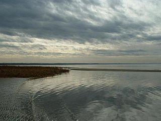
Eastham is a town in Barnstable County, Massachusetts, United States, Barnstable County being coextensive with Cape Cod. The population was 5,752 at the 2020 census.

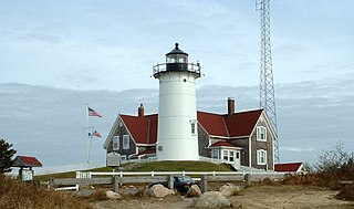
Truro is a town in Barnstable County, Massachusetts, United States, comprising two villages: Truro and North Truro. Located slightly more than 100 miles (160 km) by road from Boston, it is a summer vacation community just south of the northern tip of Cape Cod, in an area known as the "Outer Cape". English colonists named it after Truro in Cornwall, United Kingdom.

Wareham is a town in Plymouth County, Massachusetts, United States. As of the 2022 census, the town had a population of 23,303.

Burien is a suburban city in King County, Washington, United States, located south of Seattle on Puget Sound. As of the 2020 census, Burien's population was 52,066, which is a 56.3% increase since incorporation in 1993, making it the 25th most populous city in Washington. An annexation in 2010 increased the city's population significantly.

Sunnydale is the fictional setting for the U.S. television drama Buffy the Vampire Slayer (1997–2003). The series creator Joss Whedon conceived the town as a representation of a generic Californian city, as well as a narrative parody of the all-too-serene towns typical in traditional horror films.

Bourne is a town in Barnstable County, Massachusetts, United States. The population was 20,452 at the 2020 census.
Falmouth is a town in Barnstable County, Massachusetts, United States. The population was 32,517 at the 2020 census, making Falmouth the second-largest municipality on Cape Cod after Barnstable. The terminal for the Steamship Authority ferries to Martha's Vineyard is located in the village of Woods Hole in Falmouth. Woods Hole also contains several scientific organizations such as the Woods Hole Oceanographic Institution (WHOI), the Marine Biological Laboratory (MBL), the Woodwell Climate Research Center, NOAA's Woods Hole Science Aquarium, and the scientific institutions' various museums.

Orleans is a town in Barnstable County, Massachusetts situated along Cape Cod. The population was 6,307 at the 2020 census.
Bergvliet is a suburb of Cape Town, South Africa. Bergvliet, which means "Mountain Streamlet" in Afrikaans, is bordered by Retreat, Meadowridge, Tokai, and Heathfield.

Tamboerskloof is a neighbourhood and suburb of Cape Town, South Africa. It lies on the slopes of Lion's Head and Signal Hill, adjacent to the neighbourhoods of Gardens and Bo-Kaap. Tamboerskloof is one of the contiguous group of neighbourhoods referred to as the City Bowl.

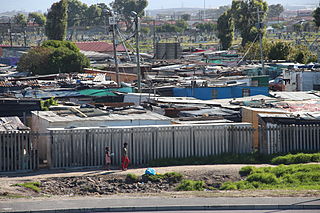
Mitchells Plain is a large census designated sub-place located within the City of Cape Town, Western Cape, South Africa and situated about 28 km (17 mi) from the Cape Town city centre. It is one of South Africa's largest residential areas and contains multiple smaller suburbs. It is located on the Cape Flats on the False Bay coast between Muizenberg and Khayelitsha. Conceived of as a "model suburb" by the apartheid government, it was built during the 1970s to provide housing for Coloured victims of forced removal due to the implementation of the Group Areas Act.

Milnerton is a seaside town on Table Bay and is located north of Cape Town in South Africa. It is located 11 kilometres to the north of the city's centre.

Delft is a township on the outskirts of Cape Town, South Africa. It is situated next to the Cape Town International Airport, Belhar, Blue Downs, Ikwezi Park, Mandalay, Luzuko, Phillipi East, and Site C, Khayelitsha. It is known for its recreational events, youth empowerment organizations such as Enkosi Foundation and the community has establish a motherbody organisation, the Delft Community Development Forum. Delft is a community that consists of numerous government built housing projects such as the N2 Gateway. In 2022 Delft was the fastest growing community in Cape Town.

Barnstable is a town in the U.S. state of Massachusetts and the county seat of Barnstable County. Barnstable is the largest community, both in land area and population, on Cape Cod, and is one of thirteen Massachusetts municipalities that have been granted city forms of government by the Commonwealth of Massachusetts but wish to retain "the town of" in their official names. At the 2020 census it had a population of 48,916. The town contains several villages within its boundaries. Its largest village, Hyannis, is the central business district of the county and home to Barnstable Municipal Airport, the airline hub of Cape Cod and the islands of Martha's Vineyard and Nantucket. Additionally, Barnstable is a 2007 winner of the All-America City Award.
The Fish Hoek Valley is situated in the Cape Peninsula, eighteen miles south of Cape Town, South Africa. It takes its name from the town of Fish Hoek on the False Bay coast.

Thornton is a southern suburb of Cape Town, South Africa. Thornton is situated only 10 kilometres (6 mi) east of the city centre, adjacent to Pinelands. Like Pinelands, Thornton is a mainly residential suburb with an abundance of trees. It is bordered by the Elsieskraal River, Pinelands, Viking Way, and the M7 Jakes Gerwel Drive. Many of the streets in Thornton are named after Viking themes, such as Thor Circle, Odin Drive and Viking Way. Others are named after trees, such as Poplar Avenue and Sipres Avenue.
Bishop Lavis is a suburb of Cape Town, located 15 kilometres (9 mi) east of the city centre near Cape Town International Airport. It had, as of 2001, a population of 44,419 people, of whom 97% described themselves as Coloured, and 90% spoke Afrikaans while 9% spoke English. The official 2011 census gave the population figure as 26,482.
