Cape Town is the legislative capital of South Africa. It is the country's oldest city and the seat of the Parliament of South Africa. It is the country's second-largest city, after Johannesburg, and the largest in the Western Cape. The city is part of the City of Cape Town metropolitan municipality.

The Limpopo River rises in South Africa and flows generally eastward through Mozambique to the Indian Ocean. The term Limpopo is derived from Rivombo (Livombo/Lebombo), a group of Tsonga settlers led by Hosi Rivombo who settled in the mountainous vicinity and named the area after their leader. The river has been called the Vhembe by local Venda communities of the area where now that name has been adopted by the South African government as its District Municipality in the north, a name that was also suggested in 2002 as a possible title for the province but was voted against. The river is approximately 1,750 km (1,090 mi) long, with a drainage basin of 415,000 km2 (160,000 sq mi) in size. The mean discharge measured over a year is 170 m3/s (6,000 cu ft/s) to 313 m3/s (11,100 cu ft/s) at its mouth. The Limpopo is the second largest African river that drains to the Indian Ocean, after the Zambezi River.

The Orange River is a river in Southern Africa. It is the longest river in South Africa. With a total length of 2,432 km (1,511 mi), the Orange River Basin extends from Lesotho into South Africa and Namibia to the north. It rises in the Drakensberg mountains in Lesotho, flowing westwards through South Africa to the Atlantic Ocean. The river forms part of the international borders between South Africa and Lesotho and between South Africa and Namibia, as well as several provincial borders within South Africa. Except for Upington, it does not pass through any major cities. The Orange River plays an important role in the South African economy by providing water for irrigation and hydroelectric power. The river was named the Orange River in honour of the Dutch ruling family, the House of Orange, by the Dutch explorer Robert Jacob Gordon. Other names include simply the word for river, in Khoekhoegowab orthography written as !Garib, which is rendered in Afrikaans as Gariep River with the intrusion of a velar fricative in place of the alveolar click, Groote River or Senqu River, derived from ǂNū "Black". It is known in isiZulu as isAngqu.

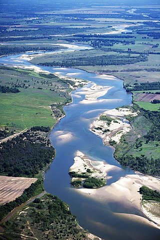
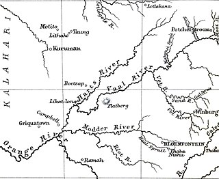
The Vaal River is the largest tributary of the Orange River in South Africa. The river has its source near Breyten in Mpumalanga province, east of Johannesburg and about 30 kilometres (19 mi) north of Ermelo and only about 240 kilometres (150 mi) from the Indian Ocean. It then flows westwards to its confluence with the Orange River southwest of Kimberley in the Northern Cape. It is 1,458 kilometres (906 mi) long, and forms the border between Mpumalanga, Gauteng and North West Province on its north bank, and the Free State on its south.

The Red River, or sometimes the Red River of the South to differentiate it from the Red River in the north of the continent, is a major river in the Southern United States. It was named for its reddish water color from passing through red-bed country in its watershed. It is known as the Red River of the South to distinguish it from the Red River of the North, which flows between Minnesota and North Dakota into the Canadian province of Manitoba. Although once a tributary of the Mississippi River, the Red River is now a tributary of the Atchafalaya River, a distributary of the Mississippi that flows separately into the Gulf of Mexico. This confluence is connected to the Mississippi River by the Old River Control Structure.

Monrovia is the capital and largest city of Liberia. Founded in 1822, it is located on Cape Mesurado on the Atlantic coast and as of the 2022 census had 1,761,032 residents, home to 33.5% of Liberia’s total population. Its Metro Area including Montserrado and Margibi counties largely being urbanized, was home to 2,225,911 inhabitants as of the 2022 census. As the nation's primate city, Monrovia is the country's economic, financial and cultural center; its economy is primarily centered on its harbor and its role as the seat of Liberian government.

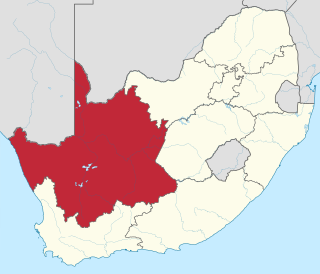
The Northern Cape is the largest and most sparsely populated province of South Africa. It was created in 1994 when the Cape Province was split up. Its capital is Kimberley. It includes the Kalahari Gemsbok National Park, part of the Kgalagadi Transfrontier Park and an international park shared with Botswana. It also includes the Augrabies Falls and the diamond mining regions in Kimberley and Alexander Bay.

Swellendam Municipality is a local municipality located within the Overberg District Municipality, in the Western Cape province of South Africa. As of 2011, it had a population of 35,916. Its municipality code is WC034.

The Great Kei River is a river in the Eastern Cape province of South Africa. It is formed by the confluence of the Black Kei River and White Kei River, northeast of Cathcart. It flows for 320 km (199 mi) and ends in the Great Kei Estuary at the Indian Ocean with the small town Kei Mouth on the west bank. Historically the Great Kei River formed the southwestern border of the Transkei region as was formerly known as the Nciba River.

Gamtoos River or Gamptoos River is a river in the Eastern Cape Province, South Africa. It is formed by the confluence of the Kouga River and the Groot River and is approximately 645 kilometres (401 mi) long with a catchment area of 34,635 square kilometres (13,373 sq mi).

The Umfolozi River is a river in KwaZulu-Natal, a province of South Africa. It is formed by the confluence of the Black and White Umfolozi Rivers near the southeastern boundary of the Hluhluwe-Umfolozi Game Reserve. The isiZulu name imFolozi is generally considered to describe the zigzag course followed by both tributaries, though other explanations have been given.

The Harts River is a northern tributary of the Vaal River, which in turn is the largest tributary of the Orange River. Its source is in the North West Province, but the greater part of its basin is located in the Northern Cape Province, which it enters a few kilometers downstream from the Taung Dam.
Salt River is a suburb of Cape Town, located near Table Bay, to the east of Cape Town's central business district. Salt River is served by a railway station of the same name, and has the postcode 7925. It is noted for its association with the clothing and textiles industry. The name Salt River is a translation of the Dutch "Soutrivier".
The Elsieskraal River is a small river that flows through the Cape Town metropolitan area, in South Africa. It rises in the Tygerberg Hills and flows in a generally south westerly direction to its confluence with the Black River just south of Pinelands. 65% of the course of the Elsieskraal River has been canalised to prevent flooding. Its catchment is part of the Central Management Area of the City of Cape Town. As most of the catchment area is urbanised and the river receives rapid runoff from roads, roofs and other impermeable surfaces it is prone to rapid increases in discharge after rain.

Observatory is a suburb in Cape Town, South Africa, colloquially known as Obs. Bordered by Mowbray to the south and Salt River to the northwest, the area is best known as a student neighbourhood associated with the nearby University of Cape Town and Groote Schuur Hospital. It takes its name from the South African Astronomical Observatory headquarters, built in 1829 by the Royal Observatory.

Colesberg is a town with 17,354 inhabitants in the Northern Cape province of South Africa, located on the main N1 road from Cape Town to Johannesburg.

The Redoubt Duijnhoop was a square demi-bastioned clay and timber Redoubt built fort constructed at the mouth of the Salt River, leading into Table Bay, South Africa in January–February 1654. It formed part of the defences of the Vereenigde Oost-Indische Compagnie 'VOC' replenishment station, which had been established under Jan van Riebeeck in 1652. The purpose of the station was to supply ships travelling between the Netherlands and the Dutch East Indies.

The Eerste River, located in the Western Cape, South Africa, rises on Dwarsberg 60 km east of Cape Town at the head of Jonkershoek valley. The Eerste River catchment covers the eastern part of the Cape Flats lying to the west of the Hottentots Holland Mountains and south of the Tygerberg where the Kuils River tributary rises east of Kanonkop. The Eerste River is a short river; its length has been given as 40 km. The major tributary, Kuils River, is approximately 30 km long to its point of confluence with the Eerste River.

The Fort de Goede Hoop was the first military building to be erected in what is now Cape Town. It was built in 1652, and was in use until 1674 when it was superseded by the Castle of Good Hope.

The Black River(Swartrivier) is a river in Cape Town, South Africa. It is a tributary of the Salt River together with the Liesbeeck River and the Elsieskraal River. It rises in Arderne Gardens and flows underground initially beneath Main Road and the railway line, before continuing as a canal through Claremont and Rondebosch, then uncanalised through Mowbray, Observatory and Maitland after which it joins the Salt River. Its catchment is part of the Central Management Area of the City of Cape Town and the city has canalised 58% of the river.


