
Dutchess County is a county in the U.S. state of New York. As of the 2020 census, the population was 295,911. The county seat is the city of Poughkeepsie. The county was created in 1683, one of New York's first twelve counties, and later organized in 1713. The county is part of the Hudson Valley region of the state.

Table Mountain is a flat-topped mountain forming a prominent landmark overlooking the city of Cape Town in South Africa. It is a significant tourist attraction, with many visitors using the cableway or hiking to the top. Table Mountain National Park is the most visited national park in South Africa, attracting 4.2 million people every year for various activities. The mountain has 8,200 plant species, of which around 80% are fynbos, meaning fine bush. It forms part of the Table Mountain National Park, and part of the lands formerly ranged by Khoe-speaking clans, such as the !Uriǁʼaes. It is home to a large array of mostly endemic fauna and flora. Its top elevates about 1.000 m above the surrounding city, making the popular hike upwards on a large variety of different, often steep and rocky pathways a serious mountain tour which requires fitness, preparation and hiking equipment.

Beacon Falls is a town in western New Haven County, Connecticut, United States. The town is part of the Naugatuck Valley Planning Region & is around 6 miles from Waterbury. It lies in the southwestern part of the state, and is bisected by the Naugatuck River. The population was 6,000 at the 2020 census, down from 6,049 at the 2010 census.
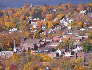
Beacon is a city located on the Hudson River in Dutchess County, New York, United States. As of the 2020 census, the city's population was 13,769. Beacon is part of the Kiryas Joel–Poughkeepsie–Newburgh Metropolitan Statistical Area as well as the larger New York–Newark–Bridgeport, New York–New Jersey–Connecticut–Pennsylvania Combined Statistical Area.

Plettenberg Bay, nicknamed Plett, is the primary town of the Bitou Local Municipality in the Western Cape Province of South Africa. According to the census of 2001, the town had a population of 29,149. It was originally named Bahia Formosa by early Portuguese explorers and lies on South Africa's Garden Route 210 km from Port Elizabeth and about 600 km from Cape Town.
The Naugatuck River Valley is the watershed area of the Naugatuck River in the western part of Connecticut. The Naugatuck Valley straddles parts of Litchfield County, New Haven, and Fairfield counties. The Route 8 corridor and Waterbury Branch of the Metro-North railroad line run along the river valley. Geographically, it comprises the municipalities located within the Naugatuck River basin. During the 19th and 20th centuries, the area was one of the main manufacturing centers in New England, and most of the communities around the river were emblematic New England mill towns.

The Cape Peninsula is a generally mountainous peninsula that juts out into the Atlantic Ocean at the south-western extremity of the African continent. At the southern end of the peninsula are Cape Point and the Cape of Good Hope. On the northern end is Table Mountain, overlooking Table Bay and the City Bowl of Cape Town, South Africa. The peninsula is 52 km long from Mouille point in the north to Cape Point in the south. The Peninsula has been an island on and off for the past 5 million years, as sea levels fell and rose with the ice age and interglacial global warming cycles of, particularly, the Pleistocene. The last time that the Peninsula was an island was about 1.5 million years ago. Soon afterwards it was joined to the mainland by the emergence from the sea of the sandy area now known as the Cape Flats. The towns and villages of the Cape Peninsula and Cape Flats, and the undeveloped land of the rest of the peninsula now form part of the City of Cape Town metropolitan municipality. The Cape Peninsula is bounded to the north by Table Bay, to the west by the open Atlantic Ocean, and to the east by False Bay in the south and the Cape Flats in the north.

The N2 is a national route in South Africa that runs from Cape Town through George, Gqeberha, East London, Mthatha, Port Shepstone and Durban to Ermelo. It is the main highway along the Indian Ocean coast of the country. Its current length of 2,255 kilometres (1,401 mi) makes it the longest numbered route in South Africa.

Noordhoek is a seaside town in the Western Cape, South Africa, located below Chapman's Peak on the west coast of the Cape Peninsula and is approximately 35 kilometres (22 mi) to the south of Cape Town. The name "Noordhoek" was taken from Dutch and literally means "north corner". It was given this name in 1743 as being the northern corner of the Slangkop farm. The first permanent resident of European origin is Jaco Malan who built his house there. In 1857, the region was divided into six plots, most of which were bought by a single family, that of the de Villiers. Noordhoek nevertheless remains a predominantly rural area where farmers grow vegetables to supply ships calling at Simon's Town. It is best known for its shoreline and its long, wide, sandy beach, which stretches south to the neighbouring village of Kommetjie. Near the southern end of this beach is the wreck of the steamship "Kakapo", which ran aground in 1900, when the captain mistook Chapman's Peak for the Cape of Good Hope and put the helm over to port.

Mitchells Plain is a large census designated sub-place located within the City of Cape Town, Western Cape, South Africa and situated about 28 km (17 mi) from the Cape Town city centre. It is one of South Africa's largest residential areas and contains multiple smaller suburbs. It is located on the Cape Flats on the False Bay coast between Muizenberg and Khayelitsha. Conceived of as a "model suburb" by the apartheid government, it was built during the 1970s to provide housing for Coloured victims of forced removal due to the implementation of the Group Areas Act.

The Cape Fold Belt is a fold and thrust belt of late Paleozoic age, which affected the sequence of sedimentary rock layers of the Cape Supergroup in the southwestern corner of South Africa. It was originally continuous with the Ventana Mountains near Bahía Blanca in Argentina, the Pensacola Mountains, the Ellsworth Mountains and the Hunter-Bowen orogeny in eastern Australia. The rocks involved are generally sandstones and shales, with the shales persisting in the valley floors while the erosion resistant sandstones form the parallel ranges, the Cape Fold Mountains, which reach a maximum height of 2325 m at Seweweekspoortpiek.

Fishkill Creek is a tributary of the Hudson River in Dutchess County, New York, United States. At 33.5 miles (53.9 km) it is the second longest stream in the county, after Wappinger Creek. It rises in the town of Union Vale and flows generally southwest to a small estuary on the Hudson just south of Beacon. Part of its 193-square-mile (500 km2) watershed is in Putnam County to the south. Sprout Creek, the county's third-longest creek, is its most significant tributary. Whaley and Sylvan lakes and Beacon Reservoir, its largest, deepest and highest lakes, are among the bodies of water within the watershed.

Parow is a town of Cape Town in the Western Cape, South Africa and a Northern Suburb of the City of Cape Town Metropolitan Municipality founded by Johann Heinrich Ferdinand Parow who arrived in the locality in 1865.

The A4059 road is a single-carriageway north–south road that runs between the A470 at Brecon Beacons National Park and the A470 at Abercynon.

Table Mountain Sandstone (TMS) is a group of rock formations within the Cape Supergroup sequence of rocks. Although the term "Table Mountain Sandstone" is still widely used in common parlance, the term TMS is no longer formally recognized; the correct name is the "Peninsula Formation Sandstone", which is part of the Table Mountain Group. The designation "Table Mountain Sandstone" will, however, in deference to the title, continue to be used in the rest of this article. The name is derived from the famous landmark in Cape Town, Table Mountain.
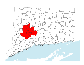
The Central Naugatuck Valley is a region of Connecticut in New Haven and Litchfield counties located approximately 70 miles (110 km) northeast of New York City and 110 miles (180 km) southwest of Boston, United States. The region comprises 13 towns: Beacon Falls, Bethlehem, Cheshire, Middlebury, Naugatuck, Oxford, Prospect, Southbury, Thomaston, Waterbury, Watertown, Wolcott, and Woodbury.

Cape Town lies at the south-western corner of the continent of Africa. It is bounded to the south and west by the Atlantic Ocean, and to the north and east by various other municipalities in the Western Cape province of South Africa.
Eli Cross, is a Canadian politician in Newfoundland and Labrador, Canada. He was elected to the Newfoundland and Labrador House of Assembly in the 2011 provincial election. A member of the Progressive Conservative Party of Newfoundland and Labrador, he represented the electoral district of Bonavista North. In the 2015 election, Cross was defeated by Liberal Derrick Bragg in the new Fogo Island-Cape Freels riding.

Maclear's Beacon is a triangulation station used in Maclear's arc measurement for Earth's circumference determination.

Westridge is a neighbourhood located within the Mitchells Plain urban area of the City of Cape Town in the Western Cape province of South Africa. It is located in the western part of the Mitchells Plain area. The Westridge Gardens, which hosts several indigenous Cape Flats fynbos species, is an important large public park in the area located in the north of Westridge.

