
Cape Town is the legislative capital of South Africa. It is the country's oldest city and the seat of the Parliament of South Africa. It is the country's second-largest city, after Johannesburg, and the largest in the Western Cape. The city is part of the City of Cape Town metropolitan municipality.

Robben Island is an island in Table Bay, 6.9 kilometres (4.3 mi) west of the coast of Bloubergstrand, north of Cape Town, South Africa. It takes its name from the Dutch word for seals (robben), hence the Dutch/Afrikaans name Robbeneiland, which translates to Seal(s) Island.

Kangaroo Island, also known as Karta Pintingga, is Australia's third-largest island, after Tasmania and Melville Island. It lies in the state of South Australia, 112 km (70 mi) southwest of Adelaide. Its closest point to the mainland is Snapper Point in Backstairs Passage, which is 13.5 km (8.4 mi) from the Fleurieu Peninsula.

Casco Bay is an inlet of the Gulf of Maine on the southern coast of Maine, New England, United States. Its easternmost approach is Cape Small and its westernmost approach is Two Lights in Cape Elizabeth. The city of Portland sits along its southern edge and the Port of Portland lies within.

A water taxi or a water bus is a watercraft used to provide public or private transport, usually, but not always, in an urban environment. Service may be scheduled with multiple stops, operating in a similar manner to a bus, or on demand to many locations, operating in a similar manner to a taxi. A boat service shuttling between two points would normally be described as a ferry rather than a water bus or taxi.

Capsizing or keeling over occurs when a boat or ship is rolled on its side or further by wave action, instability or wind force beyond the angle of positive static stability or it is upside down in the water. The act of recovering a vessel from a capsize is called righting. Capsize may result from broaching, knockdown, loss of stability due to cargo shifting or flooding, or in high speed boats, from turning too fast.

The Cape Peninsula is a generally mountainous peninsula that juts out into the Atlantic Ocean at the south-western extremity of the African continent. At the southern end of the peninsula are Cape Point and the Cape of Good Hope. On the northern end is Table Mountain, overlooking Table Bay and the City Bowl of Cape Town, South Africa. The peninsula is 52 km long from Mouille point in the north to Cape Point in the south. The Peninsula has been an island on and off for the past 5 million years, as sea levels fell and rose with the ice age and interglacial global warming cycles of, particularly, the Pleistocene. The last time that the Peninsula was an island was about 1.5 million years ago. Soon afterwards it was joined to the mainland by the emergence from the sea of the sandy area now known as the Cape Flats. The towns and villages of the Cape Peninsula and Cape Flats, and the undeveloped land of the rest of the peninsula now form part of the City of Cape Town metropolitan municipality. The Cape Peninsula is bounded to the north by Table Bay, to the west by the open Atlantic Ocean, and to the east by False Bay in the south and the Cape Flats in the north.

The Ethan Allen was a 40-foot, glass-enclosed tour boat operated by Shoreline Cruises on Lake George in upstate New York. On October 2, 2005, at 2:55 p.m. local time, with 47 passengers—mostly seniors—aboard, the Ethan Allen capsized and sank just south of Cramer Point in the Town of Lake George. Twenty passengers died, causing government regulators to consider new laws on passenger boat capacity.

Shark cage diving is underwater diving or snorkeling where the observer remains inside a protective cage designed to prevent sharks from making contact with the divers. Shark cage diving is used for scientific observation, underwater cinematography, and as a tourist activity. Sharks may be attracted to the vicinity of the cage by the use of bait, in a procedure known as chumming, which has attracted some controversy as it is claimed to potentially alter the natural behaviour of sharks in the vicinity of swimmers.
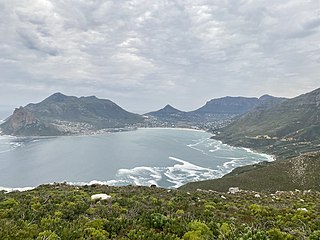
Hout Bay is a seaside suburb of Cape Town in the Western Cape province of South Africa. It is situated in a valley on the Atlantic seaboard of the Cape Peninsula, twenty kilometres south of the Central business district of Cape Town. The name "Hout Bay" can refer to the town, the bay on which it is situated, or the entire valley.

Governor Stone is a historic schooner, built in 1877, in Pascagoula, Mississippi, United States. She is the only surviving two-masted coasting cargo schooner built on the Gulf Coast of the United States, and is only one of five such surviving US-built ships. On 4 December 1991, she was added to the US National Register of Historic Places. One year later, the schooner was designated a US National Historic Landmark. She is presently berthed at Saint Andrews Marina in Panama City, Florida, where she is maintained by a nonprofit group. Sailing tours are regularly scheduled.
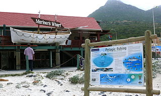
Mariner's Wharf is a prominent landmark and tourist attraction in Hout Bay, South Africa. Situated between the beach and the adjacent harbor entrance, it was originally built in 1979 as workshops, storage and offices by Stanley Dorman for his fishing operations. Subsequently, due to a serious decline in the industry he decided to repurpose the structure, converting it into a harbor front emporium. Initially it consisted of a fresh fish market, an outdoor fish-and-chips bistro, sea-shanty restaurant as well as a small shop specializing in local seashells and souvenirs.
Canada's 2008 annual commercial seal hunt in the Gulf of St. Lawrence and around Newfoundland, Quebec and Nova Scotia began on March 28. The hunting season lasts from mid-November to mid-May, but the hunt mainly occurs in March and April. Canada's seal hunt is the world's largest hunt for marine mammals.
L'Acadien II was a Canadian-registered fishing vessel that capsized and sank on March 29, 2008. The vessel was being towed by Canadian Coast Guard Ship (CCGS) Sir William Alexander off Cape Breton, Nova Scotia at the time of the incident. Two of the crew of six were rescued and four men died in the incident. Recovery efforts have not located the sunken trawler nor the missing crew member who is now presumed dead. Canadian authorities have launched independent investigations into the incident.
Dozens of fortifications were built in Cape Town and the Cape Peninsula between the 1650s and the 1940s. Most have gone, but a few still stand.

The vessel MV Blythe Star was a coastal freighter which foundered off south-western Tasmania in October 1973. The crew of 10 successfully took to a small inflatable liferaft but drifted undiscovered. A search for the ship and its crew led to the largest maritime search operation conducted in Australia to that time.
Marion Marie Stringer Darby was a New Zealand marine biologist and teacher. She was the first New Zealand woman to visit the Antarctic mainland. In January 1968, she travelled on the Magga Dan, the first tourist vessel to the Ross Sea, and visited Scott Base with other staff and tourists. She prepared a checklist of sub-Antarctic birds for the information of tourists on board and later wrote an article on summer seabirds to be seen between New Zealand and McMurdo Sound. Mt Darby in Antarctica is named after her.


