Westgate or West Gate may refer to:

Westgate is a village in the civil parish of Stanhope, in County Durham, England. It is situated in Weardale between St John's Chapel and Eastgate. In the 2001 census Westgate had a population of 298. Westgate is also the entrance to Slitt wood and an old abandoned lead mine. Other features of the village include a caravan site and a football and basketball court.
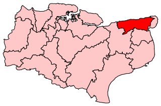
North Thanet was a constituency in Kent. It was represented in the House of Commons of the UK Parliament since its 1983 creation until abolition by Sir Roger Gale, a Conservative.
Bergvliet is a suburb of Cape Town, South Africa. Bergvliet, which means "Mountain Streamlet" in Afrikaans, is bordered by Retreat, Meadowridge, Tokai, and Heathfield.

Tamboerskloof is a neighbourhood and suburb of Cape Town, South Africa. It lies on the slopes of Lion's Head and Signal Hill, adjacent to the neighbourhoods of Gardens and Bo-Kaap. Tamboerskloof is one of the contiguous group of neighbourhoods referred to as the City Bowl.

Mitchells Plain is a large census designated sub-place located within the City of Cape Town, Western Cape, South Africa and situated about 28 km (17 mi) from the Cape Town city centre. It is one of South Africa's largest residential areas and contains multiple smaller suburbs. It is located on the Cape Flats on the False Bay coast between Muizenberg and Khayelitsha. Conceived of as a "model suburb" by the apartheid government, it was built during the 1970s to provide housing for Coloured victims of forced removal due to the implementation of the Group Areas Act.

Nyanga is a township in the Western Cape, South Africa. Its name in Xhosa means "moon" and it is one of the oldest black townships in Cape Town. It was established as a result of the migrant labour system. In 1948 black migrants were forced to settle in Nyanga as Langa had become too small. Nyanga was one of the poorest places in Cape Town and is still one of the most dangerous parts of Cape Town. In 2001 its unemployment rate was estimated at being approximately 56% and HIV/AIDS is a huge community issue.
Westgate is a residential neighbourhood in the southwest quadrant of Calgary, Alberta. It is bounded by Bow Trail to the north, 45 Street W to the east, 17 Avenue S to the south and Sarcee Trail to the west. Edworthy Park is located north of the community.

Philippi is a large urban and semi-urban area in Cape Town's Cape Flats region, in the Western Cape, South Africa. It comprises the Philippi Horticultural Area to the west, and the neighbourhoods of Brown's Farm, Philippi East and Samora Machel located within its eastern half. The neighbourhoods of Gugulethu and Nyanga are located to its north. The horticultural area is sparsely populated compared to the surrounding city and contains many farms.
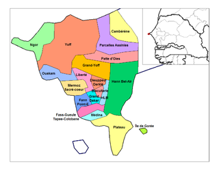
Almadies Arrondissement is an arrondissement of the Dakar Department in the Dakar Region of Senegal. Almadies is considered the most upmarket residential neighbourhood in Central & Western Africa and it holds the residences of numerous foreign Ambassadors and expatriates. It is also considered one of the most expensive and premiere neighbourhoods in Africa. It also holds numerous Embassies and agencies of the UN.
The city of St. John's is made up of many neighbourhoods. Neighbourhoods such as Georgestown and Rabbittown have long histories in the city and were among the first residential neighbourhoods to be built, while other neighbourhoods such as the Goulds and Kilbride are former communities that have been amalgamated with St. John's.
Armour Heights is a neighbourhood in Toronto, Ontario, Canada, in the district of North York. It is bounded by Wilson Avenue to the south, Bathurst Street to the west, and the west branch of the Don River to the north and east. Highway 401 cuts through the centre of the neighbourhood.
Mandela Park is a neighborhood located within the Khayelitsha urban area of the City of Cape Town in the Western Cape province of South Africa. It was established in 1986 under the apartheid era government of P.W. Botha as a residential area demarcated for black South Africans moving to Cape Town from the Eastern Cape province. It was one of the few areas in South Africa where black South Africans could purchase homes with bank loans in the 1980s. Many of the streets in the neighbourhood are named after anti-apartheid activists. The Mandela Park Backyarders association is based within the community.

The Westgate area of Gloucester is centred on Westgate Street, one of the four main streets of Gloucester and one of the oldest parts of the city. The population of the Westgate ward in Gloucester was 6,687 at the time of the 2011 Census.
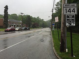
Westgate is a neighborhood in the Southwest District of Baltimore, located between Baltimore County (west) and the city neighborhood of Ten Hills (east). Its boundaries are marked by Baltimore National Pike (north), Frederick Avenue (south), Rock Glen Avenue and Edmondson Avenue (east) and the city line (west).
Tafelsig is a neighbourhood in the south eastern corner of the Mitchells Plain urban area of the City of Cape Town in the Western Cape province of South Africa.

Lentegeur is a neighbourhood in the north eastern section of the Mitchells Plain urban area of the City of Cape Town in the Western Cape province of South Africa. The 400 bed Mitchells Plain Hospital, one of Cape Town's larger hospitals, is located in the neighbourhood. The Lentegeur Sports Grounds dominate the central area of the neighbourhood.
Mandalay is a neighbourhood in the northeastern corner of the Mitchells Plain urban area of the City of Cape Town in the Western Cape province of South Africa.
Colorado is a neighbourhood in the north western part of the Mitchells Plain urban area of the City of Cape Town in the Western Cape province of South Africa.

Westridge is a neighbourhood located within the Mitchells Plain urban area of the City of Cape Town in the Western Cape province of South Africa. It is located in the western part of the Mitchells Plain area. The Westridge Gardens, which hosts several indigenous Cape Flats fynbos species, is an important large public park in the area located in the north of Westridge.


