Mouille Point

Last updated
Mouille Point
Suburb of Cape Town
Mouille Point and Green Point.jpg
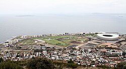
Mouille Point along the coastline with Green Point in the foreground. Robben Island in the distance, left
South Africa Western Cape location map.svg
Red pog.svg
Mouille Point
South Africa adm location map.svg
Red pog.svg
Mouille Point
Coordinates: 33°54′03″S18°24′20″E / 33.90083°S 18.40556°E / -33.90083; 18.40556 Coordinates: 33°54′03″S18°24′20″E / 33.90083°S 18.40556°E / -33.90083; 18.40556
Country South Africa
Province Western Cape
Municipality City of Cape Town
Main Place Cape Town
Area
[1]
  Total0.34 km2 (0.13 sq mi)
Population
 (2011) [1]
  Total1,714
  Density5,000/km2 (13,000/sq mi)
Racial makeup (2011)
[1]
   Black African 24.8%
   Coloured 6.9%
   Indian/Asian 2.6%
   White 59.9%
  Other5.8%
First languages (2011)
[1]
   English 71.7%
   Afrikaans 15.5%
   Xhosa 2.1%
  Other10.7%
Time zone UTC+2 (SAST)
Postal code (street)
n/a
PO box
8005
Area code 021

Mouille Point ("Mu-lee") is an affluent suburb of Cape Town, situated between the Victoria and Alfred Waterfront and Granger Bay to the east, Green Point to the south and the Atlantic Ocean to the north and west. The suburb hugs the coastline and is dominated by high-end apartment blocks.

It is a very small suburb, having only two major roads (Beach Road and Bay Road). It is home to the Mouille Point promenade, a paved promenade on the coast that is used daily by thousands of Capetonians. Behind it lies the Green Point Common, where numerous playing fields and a golf course are situated. The new Green Point Urban Park & Biodiversity Garden is just behind Mouille Point and has an entrance on Bay Road.

The name "Mouille" comes from the French word for an anchoring ground. In the early 18th century ships were often swept ashore in Table Bay and the then governor decided that a breakwater (mouille in French) was needed to protect vessels at anchor. Work began in 1743. All farmers who delivered their goods to the city were required to load up their wagons with stones, drive out to Mouille Point and offload. Slaves and convicts were used to build the breakwater but after three years of labour and high seas, just 100m had been built and the project was abandoned. In 1781 the French arrived and built a battery near the unfinished mouille, naming it Mouille Point Battery.

The Green Point Lighthouse with Devil's Peak as a backdrop The Green Point Lighthouse.jpg
The Green Point Lighthouse with Devil's Peak as a backdrop

The Green Point lighthouse is located here but, despite this, on 1 July 1966, during a fierce winter storm, a cargo ship, the S. A. Seafarer, ran aground between Mouille Point and Three Anchor Bay. Everybody on board was rescued by helicopters of 17 squadron from AFB Ysterplaat.

The Mouille Point Lighthouse is no longer in existence. It was once located at the far end of the suburb, near Granger Bay.

For many years (c. 1960s) there was, opposite the lighthouse, a drive-in roadhouse named "The Doll House", where people used to go for a snack and coffee during the day, or after a movie at night, which was served on a tray clipped to the window of the vehicle. [2] The local seagulls became wise to this smorgasbord and many a patron lost his or her sandwich to a robber gull that had landed on the roof of the car. [3]

In the period May 2020 through February 2021 there were 17 apartments sold in the suburb at an average price of R 48987 / m². [4]

Related Research Articles

<span class="mw-page-title-main">Port St Mary</span> Human settlement on the Isle of Man

Port St Mary is a village district in the south-west of the Isle of Man. The village takes its name from the former Chapel of St Mary which is thought to have overlooked Chapel Bay in the village. Its population is 1,953 according to the 2011 census. In the 19th century it was sometimes called Port-le-Murray.

<span class="mw-page-title-main">St. Paul's Bay</span> Local council in Northern Region, Malta

St. Paul's Bay is a town in the Northern Region of Malta, sixteen kilometres northwest of the capital Valletta. Saint Paul's Bay is the largest town in the Northern Region and the seat of the Northern Regional Committee.

<span class="mw-page-title-main">Sea Point</span> Suburb of Cape Town in Western Cape, South Africa

Sea Point is one of Cape Town's most affluent and densely populated suburbs, situated between Signal Hill and the Atlantic Ocean, a few kilometres to the west of Cape Town's Central Business District (CBD). Moving from Sea Point to the CBD, one passes first through the small suburb of Three Anchor Bay, then Green Point. Seaward from Green Point is the area known as Mouille Point, where the local lighthouse is situated. It borders to the southwest the suburb of Bantry Bay.

<span class="mw-page-title-main">Simon's Town</span> Seaside town in the Western Cape, South Africa

Simon's Town, sometimes spelled Simonstown, is a town in the Western Cape, South Africa and is home to Naval Base Simon's Town, the South African Navy's largest base. It is located on the shores of False Bay, on the eastern side of the Cape Peninsula. For more than two centuries it has been a naval base and harbour. The town is named after Simon van der Stel, an early governor of the Cape Colony.

<span class="mw-page-title-main">Battery Point, Tasmania</span> Suburb of Hobart, Tasmania, Australia

Battery Point is a suburb of the city of Hobart, Tasmania, Australia. It is immediately south of the central business district. It is in the local government area of City of Hobart.

<span class="mw-page-title-main">Hout Bay</span> Seaside suburb of Cape Town, Western Cape, South Africa

Hout Bay is a harbour town in the Western Cape province of South Africa. It is situated in a valley on the Atlantic seaboard of the Cape Peninsula, twenty kilometres south of Cape Town. The name "Hout Bay" can refer to the town, the bay on which it is situated, or the entire valley.

<span class="mw-page-title-main">Mitchells Plain</span> Suburb of Cape Town, in Western Cape, South Africa

Mitchells Plain is a large township located within the City of Cape Town, Western Cape, South Africa and situated about 28 km (17 mi) from the Cape Town city centre. It is one of South Africa's largest residential areas and contains multiple smaller suburbs. It is located on the Cape Flats on the False Bay coast between Muizenberg and Khayelitsha. Conceived of as a "model suburb" by the apartheid government, it was built during the 1970s to provide housing for Coloured victims of forced removal due to the implementation of the Group Areas Act.

Arakoon is an eastern suburb of the town of South West Rocks in Kempsey Shire, New South Wales, Australia. At the 2016 census, Arakoon had a population of 420 people.

<span class="mw-page-title-main">Gordon's Bay</span> Harbour town in the Western Cape, South Africa

Gordon's Bay is a harbour town in the Western Cape province of South Africa. It is included in the City of Cape Town metropolitan municipality as a suburb of the Helderberg region. It is situated on the shores of Gordon's Bay in the northeastern corner of False Bay about 58 km from Cape Town to the south of the N2 national road and is named after Robert Jacob Gordon (1743–1795), the Dutch explorer of Scottish descent.

<span class="mw-page-title-main">Newfoundland and Labrador Route 235</span> Highway in Newfoundland and Labrador, Canada

Route 235, commonly called the Cabot Highway branches off from Route 230 at Southern Bay. Both Route 230 and Route 235 head towards Bonavista, Route 230 crossing the Bonavista Peninsula at this point to service towns on the Trinity Bay side of the Peninsula whilst Route 235 stays on the Bonavista Bay side of the Peninsula, going all the way to Cape Bonavista.

<span class="mw-page-title-main">Green Point, Cape Town</span> Suburb of Cape Town in Western Cape, South Africa

Green Point is an affluent suburb on the Atlantic Seaboard of Cape Town, South Africa located to the north west of the central business district. It is a popular residential area for young professionals, alongside the sub-district of De Waterkant. Many new mid-rise apartment and mixed-use developments have gone up in recent years. Somerset Road forms the main thoroughfare lined by restaurants, cafés, delis, boutiques and nightclubs.

Dozens of fortifications were built in Cape Town and the Cape Peninsula between the 1650s and the 1940s. Most have gone, but a few still stand.

<span class="mw-page-title-main">Green Point Lighthouse, Cape Town</span> Lighthouse in Cape Town, South Africa

The Green Point Lighthouse, Cape Town is an operational lighthouse on the South African coast. First lit on 12 April 1824, it is located on Mouille Point. The lighthouse was the first solid lighthouse structure on the South African coast and the oldest operational lighthouse in South Africa. The lighthouse was commissioned by acting Governor of the Cape Colony Sir Rufane Shaw Donkin and designed by German architect Herman Shutte. Building commenced in 1821 and was completed in 1823. The lighthouse started operating in 1824. The lighthouse cost approximately £6,420 pounds sterling to build. When the lighthouse was first lit, it burned Argand lamps fueled by sperm whale oil. The light from these lanterns could be seen for 6 nautical miles. The lighthouse was expanded to its present height in 1865. In 1922, the range of the light house was extended to 22 nautical miles when 3rd order dioptric flashing lights were installed. Its present characteristic is a white light flashing every 10 seconds. In 1926, a foghorn was installed in the lighthouse despite a letter of complaint sent to the Mayor of Cape Town in 1923 by Green Point residents. Local Residents call the Green Point Lighthouse "Moaning Minnie".

<span class="mw-page-title-main">Three Anchor Bay</span> Suburb of Cape Town in Western Cape, South Africa

Three Anchor Bay is a suburb of Cape Town in the Western Cape province of South Africa.

<span class="mw-page-title-main">Delaware Breakwater Range Rear Light</span> Lighthouse

The Delaware Breakwater Range Rear Light was a lighthouse west of Lewes, Delaware. It was made obsolete by the shifting of Cape Henlopen and was disassembled and moved to Florida to become the Boca Grande Entrance Range Rear Light.

<span class="mw-page-title-main">Guichen Bay</span> Body of water

Guichen Bay, is a bay located on the south-east coast of the Australian state of South Australia about 115 kilometres northwest of the regional city of Mount Gambier and about 270 kilometres south-southeast of the state capital of Adelaide. It was named in 1802 by the Baudin expedition of 1800-03 after Luc Urbain de Bouëxic, comte de Guichen. The town of Robe is located at the southern end of the bay.

<span class="mw-page-title-main">Green Point Common</span> Park in Green Point, Cape Town, in South Africa

Green Point Common, is a park in Green Point, Cape Town, in South Africa, where numerous playing fields and a golf course are situated. The Green Point Urban Park & Biodiversity Garden is just behind Mouille Point and has an entrance on Bay Road.

<span class="mw-page-title-main">Outline of Cape Town</span> List of links to articles about Cape Town on Wikipedia

The following outline is provided as an overview of and topical guide to Cape Town:

<span class="mw-page-title-main">M6 (Cape Town)</span> Metropolitan route in the City of Cape Town, South Africa

The M6 is a short metropolitan route in Cape Town, South Africa. It connects the Cape Town CBD with Glencairn on the False Bay coast via Sea Point, Camps Bay and Hout Bay. It is an alternative route to the M4 for travel between Cape Town CBD and Glencairn, with the M6 passing to the west of Table Mountain.

<span class="mw-page-title-main">Mouille Point Lighthouse</span>

The Mouille Point Lighthouse was a lighthouse in Mouille Point in Cape Town, South Africa, built in 1842 and demolished in 1908. It was located on the northeast side of Table Bay in Granger Bay. The dangerous rocks at Mouille Point necessitated it.

References

  1. 1 2 3 4 "Sub Place Mouille Point". Census 2011.
  2. "Mouille Point, Cape Town neighbourhood, Information - Bay Road, Cape Town". 2016-10-21. Archived from the original on 2016-10-21. Retrieved 2021-12-30.
  3. "Mouille Point, Cape Town neighbourhood, Information - Bay Road, Cape Town". 2016-03-22. Archived from the original on 2016-03-22. Retrieved 2021-12-30.
  4. Martin (2021-03-29). "Mouille Point Property Market Review". Lance Real Estate. Retrieved 2021-03-29.