Blaauwberg Conservation Area

Last updated

Blaauwberg Nature Reserve
Blaauwberg Conservation Area
Location Cape Town
Coordinates 33°46′05″S18°27′10″E / 33.76806°S 18.45278°E / -33.76806; 18.45278
Area1,445 ha (3,570 acres)
2,000 ha (4,900 acres) planned
Established2007
City of Cape Town - Blaauwberg Nature Reserve
South Africa relief location map.svg
Red pog.svg
Blaauwberg Conservation Area (South Africa)
South Africa Western Cape relief location map.svg
Red pog.svg
Blaauwberg Conservation Area (Western Cape)

Blaauwberg Nature Reserve was proclaimed a local and provincial nature reserve in 2007. The reserve has views down fynbos slopes, across the city,[ where? ] to seven kilometres of rocky and sandy coastline and the ocean and beyond. The reserve presents itself as one of the few viewpoints in the world from where you can see two proclaimed world heritage sites, namely Table Mountain and Robben Island.[ citation needed ]

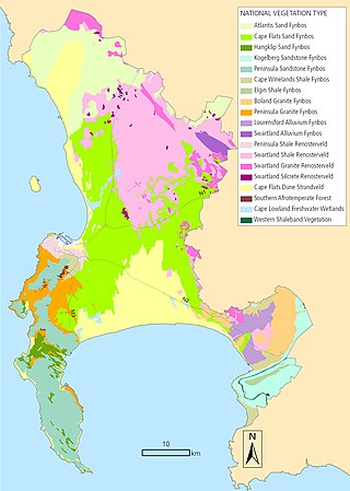
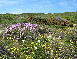
Blaauwberg Nature Reserve conserves three threatened vegetation types: Cape Flats Dune Strandveld (endangered), Swartland Shale Renosterveld (critically endangered) and Cape Flats Sand Fynbos (critically endangered). The rich biodiversity embraces a wetland, 624 plant species, 41 mammal species (including whales, dolphins and seals), 166 bird species, 30 reptile species and four amphibians. The reserve is one of the few City of Cape Town nature reserves where it is possible to find white-tailed mouse (Mystromys albicaudatus) and Aardvark (Orycteropus afer).

The holotype of Scelotes montispectus (Blaauwberg Dwarf Burrowing Skink) was collected within Blaauwberg Nature Reserve. There is also a population of Mystromys albicaudatus (white-tailed mouse) listed as endangered in the latest Red List of mammals of South Africa, as well as a total of eight Red List fauna species.[ citation needed ]

Within the current 1,445 ha, there is evidence of early human occupation,[ citation needed ] with shell middens dating back approximately 15,000 years. The reserve also conserves the site of the 1806 Battle of Blaauwberg, when the British took possession of the Cape from the Dutch for the second time and retained ownership until South Africa's independence. On Blaauwberg Hill, several buildings were constructed during World War II, including a radar station, a lookout and a mess room.

Since the then Blaauwberg Conservation Area's (BCA) inception, conservation in the area has progressed rapidly.[ citation needed ] Simple bollards in the coastal parking areas have stopped 4x4s from accessing and ultimately driving on the beach, and, already, the endangered vegetation has recovered and the Haematopus moquini (African black oystercatcher) has since returned. Illegal vehicles had not only endangered the vegetation and Haematopus moquini, but had destroyed a number of the shell middens.[ citation needed ]

The conservation area is also used for recreational activities such as surfing, hiking, wind surfing, whale watching and picnics. [1]

See also

Related Research Articles

<span class="mw-page-title-main">Fynbos</span> Shrubland and heathland ecoregion of southwestern South Africa

Fynbos is a small belt of natural shrubland or heathland vegetation located in the Western Cape and Eastern Cape provinces of South Africa. This area is predominantly coastal and mountainous, with a Mediterranean climate and rainy winters. The fynbos ecoregion is within the Mediterranean forests, woodlands, and scrub biome. In fields related to biogeography, fynbos is known for its exceptional degree of biodiversity and endemism, consisting of about 80% species of the Cape floral kingdom, where nearly 6,000 of them are endemic. This land continues to face severe human-caused threats, but due to the many economic uses of the fynbos, conservation efforts are being made to help restore it.

<span class="mw-page-title-main">Cape Floristic Region</span> Smallest of the six recognised floral kingdoms of the world

The Cape Floral Region is a floristic region located near the southern tip of South Africa. It is the only floristic region of the Cape Floristic Kingdom, and includes only one floristic province, known as the Cape Floristic Province.

<span class="mw-page-title-main">Geometric tortoise</span> Species of tortoise

The geometric tortoise is a critically endangered species of tortoise and one of three members of the genus Psammobates. It is found in a very small section in the South-Western Cape of South Africa.

<span class="mw-page-title-main">Rondebosch Common</span> Conservation area in Cape Town

Rondebosch Common is an open common of about 40 hectares in Rondebosch, Cape Town in South Africa. A common is defined as "a piece of open land for public use, esp. in a village or town". It contains one of the few surviving pockets of the critically endangered “Cape Flats Sand Fynbos” vegetation type, which exists nowhere else in the world.

The Milnerton Racecourse Nature Reserve is a lowland conservation area located in the City of Cape Town, South Africa.

<span class="mw-page-title-main">Biodiversity of Cape Town</span> Diversity of the natural environment of Cape Town

The Biodiversity of Cape Town is the variety and variability of life within the geographical extent of the City of Cape Town metropolitan municipality, excluding the Prince Edward Islands. The terrestrial vegetation is particularly diverse and much of it is endemic to the city and its vicinity. Terrestrial and freshwater animal life is heavily impacted by urban development and habitat degradation. Marine life of the waters immediately adjacent to the city along the Cape Peninsula and in False Bay is also diverse, and while also impacted by human activity, the habitats are relatively intact.

<span class="mw-page-title-main">Cape Flats Dune Strandveld</span> Endangered vegetation type endemic to the coastal areas around Cape Town

Cape Flats Dune Strandveld is an endangered vegetation type. This is a unique type of Cape Strandveld that is endemic to the coastal areas around Cape Town, including the Cape Flats.

<span class="mw-page-title-main">Cape Flats Sand Fynbos</span> Vegetation type endemic to the City of Cape Town

Cape Flats Sand Fynbos (CFSF), previously known as Sand Plain Fynbos, is a critically endangered vegetation type that occurs only within the city of Cape Town. Less than 1% of this unique lowland fynbos vegetation is conserved.

<span class="mw-page-title-main">Lourensford Alluvium Fynbos</span> Vegetation type that is endemic to Cape Town, South Africa

Lourensford Alluvium Fynbos is a critically endangered vegetation type that is endemic to Cape Town. Though closest to Fynbos, it has characteristics of both Fynbos and Renosterveld vegetation and is thus actually a unique hybrid vegetation type.

<span class="mw-page-title-main">Peninsula Shale Renosterveld</span> Vegetation type found only in South Africa

Peninsula Shale Renosterveld (PSR) is a unique vegetation type that is found only on the slopes of Signal Hill and Devil's Peak in Cape Town, South Africa. It is critically endangered and exists nowhere else.

<span class="mw-page-title-main">Swartland Shale Renosterveld</span> Vegetation type endemic to the Western Cape, South Africa

Swartland Shale Renosterveld is a critically endangered vegetation type of the Western Cape, South Africa.

<span class="mw-page-title-main">Edith Stephens Wetland Park</span> Nature reserve

Edith Stephens Wetland Park is a nature reserve for wetlands and fynbos, located in the city of Cape Town, South Africa.

Witzands Aquifer Nature Reserve is a 3,000-hectare (7,400-acre) protected natural area in Cape Town, South Africa, located on the city's northern outskirts. This reserve protects an important part of Cape Town's natural and cultural heritage, including the Atlantis Aquifer. It is adjacent to the Koeberg Nature Reserve.

<span class="mw-page-title-main">Tygerberg Nature Reserve</span> Nature reserve in Cape Town, South Africa

Tygerberg Nature Reserve is a 300-hectare (740-acre) nature reserve on the Tygerberg Hills in the northern suburbs of Cape Town, South Africa.

<span class="mw-page-title-main">Wolfgat Nature Reserve</span> Coastal nature reserve in Mitchells Plain, Cape Town, South Africa

Wolfgat Nature Reserve is a coastal nature reserve in Mitchells Plain on False Bay in the Western Cape, South Africa.

<span class="mw-page-title-main">Bracken Nature Reserve</span> Protected land in Brackenfell in the Western Cape, South Africa

Bracken Nature Reserve is a 36-hectare (89-acre) piece of protected land in Brackenfell in the Western Cape, South Africa.

<span class="mw-page-title-main">Durbanville Nature Reserve</span> Piece of protected land next to the Durbanville Racecourse

Durbanville Nature Reserve is a 6-hectare (15-acre) piece of protected land, located next to the Hollywoodbets Durbanville Racecourse in the Western Cape, South Africa.

<span class="mw-page-title-main">Macassar Dunes Conservation Area</span> Coastal nature reserve in Macassar, Cape Town, South Africa

Macassar Dunes Conservation Area is a 1,116-hectare (2,760-acre) coastal nature reserve in Macassar, within the City of Cape Town, South Africa.

<span class="mw-page-title-main">Koeberg Nature Reserve</span> Nature reserve surrounding Koeberg Nuclear Power Station, South Africa

The Koeberg Nature Reserve is located in the Western Cape province of South Africa, about 30 kilometres north of Cape Town. The reserve was proclaimed in 1991 to create a buffer zone around the Koeberg Nuclear Power Station and protect the surrounding natural habitat. It is adjacent to the Witzands Aquifer Nature Reserve.

References

  1. "Environmental resources and downloads. City of Cape Town. Environmental Resource Management Dept". Archived from the original on 2012-12-23.