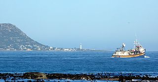
Kommetjie is a small town near Cape Town, in the Western Cape province of South Africa. It lies about halfway down the west coast of the Cape Peninsula, at the southern end of the long wide beach that runs northwards towards Chapman's Peak and Noordhoek. The community of Ocean View is located to its immediate south east.

The R300 or Kuils River Freeway is a Regional Route in the Cape Metropole, South Africa that connects Mitchells Plain with the N2, Kuils River, and the N1 at Bellville. The R300 is a freeway for its entire length; it forms part of the proposed Peninsula Expressway.
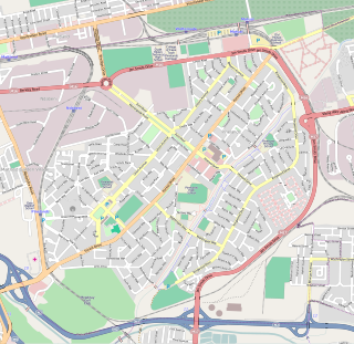
Pinelands is an affluent garden city suburb located on the edge of the southern suburbs of Cape Town, South Africa, neighbouring the suburb of Thornton, and is known for its large thatched houses and green spaces. The suburb is primarily residential and is often praised for its peacefulness and abundance of trees. Pinelands is one of the few areas in Cape Town in which sale of alcohol to the public is prohibited, but some clubs have private liquor licenses. It is a popular place for senior citizens to retire to. While there are several retirement homes in the suburb, younger people are increasingly moving in.

Somerset West is a town in the Western Cape, South Africa. Organisationally and administratively it is included in the City of Cape Town metropolitan municipality as a suburb of the Helderberg region . The vehicle registration code for Somerset West is CFM and the post code is 7130 for street addresses, and 7129 for post office boxes.

Mitchells Plain is a large township located within the City of Cape Town, Western Cape, South Africa and situated about 28 km (17 mi) from the Cape Town city centre. It is one of South Africa's largest residential areas and contains multiple smaller suburbs. It is located on the Cape Flats on the False Bay coast between Muizenberg and Khayelitsha. Conceived of as a "model suburb" by the apartheid government, it was built during the 1970s to provide housing for Coloured victims of forced removal due to the implementation of the Group Areas Act.

Brackenfell is a town in the Western Cape province of South Africa at the gateway to the Cape Winelands. Organisationally and administratively it is included in the City of Cape Town Metropolitan Municipality as a Northern Suburb and is about 30 kilometres (19 mi) east of Cape Town City Bowl. In Brackenfell a variety of property situated on the slopes of the Bottelary Hills can be found.

Durbanville is a town in the Western Cape province of South Africa, part of the greater Cape Town metropolitan area. Durbanville is a semi-rural residential suburb on the north-eastern outskirts of the metropolis and is surrounded by farms producing wine and wheat.

The Southern Suburbs are a group of Anglophone suburbs in Cape Town, Western Cape, South Africa. This group includes, among others, Observatory, Mowbray, Pinelands, Rosebank, Rondebosch, Rondebosch East, Newlands, Claremont, Hanover Park,Lansdowne, Kenilworth, Bishopscourt, Constantia, Wynberg, Ottery, Plumstead, Diep River, Bergvliet and Tokai. The area is also commonly referred to as the Cape Peninsula, often including the towns further South such as Fish Hoek.

Grassy Park is a suburb of the City of Cape Town in the Western Cape Province of South Africa.

Cape Flats Sand Fynbos (CFSF), previously known as Sand Plain Fynbos, is a critically endangered vegetation type that occurs only within the city of Cape Town. Less than 1% of this unique lowland fynbos vegetation is conserved.

Rocklands is a neighborhood located within the Mitchells Plain urban area of the City of Cape Town in the Western Cape province of South Africa. It is located in the south western most corner of Mitchells Plain and borders the community of Strandfontein to its immediate west.
Portland is a neighborhood located within the Mitchells Plain urban area of the City of Cape Town in the Western Cape province of South Africa. It is located within the central area of Mitchells Plain with Mitchells Plain Town Centre located to its immediate east.

Westgate is a neighbourhood located within the Mitchells Plain urban area of the City of Cape Town in the Western Cape province of South Africa. It is located in the central western part of Mitchells Plain. Westgate Mall is located to the neighbourhood's immediate north on the other side of Morgenster Road.
Tafelsig is a neighbourhood located within the Mitchells Plain urban area of the City of Cape Town in the Western Cape province of South Africa. It is located in the south eastern corner of the Mitchells Plain area.

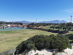
Lentegeur is a neighbourhood located within the Mitchells Plain urban area of the City of Cape Town in the Western Cape province of South Africa. It is located in the north eastern section of the Mitchells Plain area. The 400 bed Mitchells Plain Hospital, one of Cape Town's larger hospitals, is located in the neighbourhood. The Lentegeur Sports Grounds dominate central area of the neighbourhood.
Mandalay is a neighbourhood located within the Mitchells Plain urban area of the City of Cape Town in the Western Cape province of South Africa. It is located in the north eastern most corner of the Mitchells Plain area.
Colorado is a neighbourhood located within the Mitchells Plain urban area of the City of Cape Town in the Western Cape province of South Africa. It is located in the north western part of the Mitchells Plain area.

Woodlands is a neighborhood located within the Mitchells Plain urban area of the City of Cape Town in the Western Cape province of South Africa. It is located in the central western part of Mitchells Plain.
Beacon Valley is a neighborhood located within the Mitchells Plain urban area of the City of Cape Town in the Western Cape province of South Africa. It is located in the central eastern part of Mitchells Plain just north and north east of Micheals Plain Town Centre.