Cape Point is a promontory at the southeast corner of the Cape Peninsula, a mountainous and scenic landform that runs north-south for about thirty kilometres at the extreme southwestern tip of the African continent in South Africa. Table Mountain and the city of Cape Town are close to the northern extremity of the same peninsula. The cape is located at 34°21′26″S18°29′51″E, about 2.3 kilometres (1.4 mi) east and a little north of the Cape of Good Hope on the southwest corner. Although these two rocky capes are very well known, neither cape is actually the southernmost point of the mainland of Africa; that is Cape Agulhas, approximately 150 kilometres (93 mi) to the east-southeast.

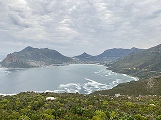
The Cape Peninsula is a generally mountainous peninsula that juts out into the Atlantic Ocean at the south-western extremity of the African continent. At the southern end of the peninsula are Cape Point and the Cape of Good Hope. On the northern end is Table Mountain, overlooking Table Bay and the City Bowl of Cape Town, South Africa. The peninsula is 52 km long from Mouille point in the north to Cape Point in the south. The Peninsula has been an island on and off for the past 5 million years, as sea levels fell and rose with the ice age and interglacial global warming cycles of, particularly, the Pleistocene. The last time that the Peninsula was an island was about 1.5 million years ago. Soon afterwards it was joined to the mainland by the emergence from the sea of the sandy area now known as the Cape Flats. The towns and villages of the Cape Peninsula and Cape Flats, and the undeveloped land of the rest of the peninsula now form part of the City of Cape Town metropolitan municipality. The Cape Peninsula is bounded to the north by Table Bay, to the west by the open Atlantic Ocean, and to the east by False Bay in the south and the Cape Flats in the north.

Cuttyhunk Island is the outermost of the Elizabeth Islands in Massachusetts. A small outpost for the harvesting of sassafras was occupied for a few weeks in 1602, arguably making it the first English settlement in New England. Cuttyhunk is located between Buzzards Bay to the north and Vineyard Sound to the south. Penikese Island and Nashawena Island are located to the north and east respectively.

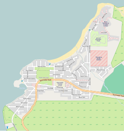
Fish Hoek is a coastal town at the eastern end of the Fish Hoek Valley on the False Bay side of the Cape Peninsula in the Western Cape, South Africa. Previously a separate municipality, Fish Hoek is now part of the City of Cape Town. As a coastal suburb of Cape Town, Fish Hoek is popular as a residence for commuters, retired people and holidaymakers alike. The traditional industries of 'trek' fishing and angling coexist with the leisure pursuits of surfing, although nearby Kommetjie is usually favoured, sailing and sunbathing. There is an active lifeguard community who utilise the beach and bay for training.

False Bay is a body of water in the Atlantic Ocean between the mountainous Cape Peninsula and the Hottentots Holland Mountains in the extreme south-west of South Africa. The mouth of the bay faces south and is demarcated by Cape Point to the west and Cape Hangklip to the east. The north side of the bay is the low-lying Cape Flats, and the east side is the foot of the Hottentots Holland Mountains to Cape Hangklip which is at nearly the same latitude as Cape Point. In plan the bay is approximately square, being roughly the same extent from north to south as east to west, with the southern side open to the ocean. The seabed slopes gradually down from north to south, and is mostly fairly flat unconsolidated sediments. Much of the bay is off the coast of the City of Cape Town, and it includes part of the Table Mountain National Park Marine Protected Area and the whole of the Helderberg Marine Protected Area. The name "False Bay" was applied at least three hundred years ago by sailors returning from the east who confused Cape Point and Cape Hangklip, which are somewhat similar in profile when approached from the southeast.
Hout Bay is a seaside suburb of Cape Town in the Western Cape province of South Africa. It is situated in a valley on the Atlantic seaboard of the Cape Peninsula, twenty kilometres south of the Central business district of Cape Town. The name "Hout Bay" can refer to the town, the bay on which it is situated, or the entire valley.

Noordhoek is a seaside town in the Western Cape, South Africa, located below Chapman's Peak on the west coast of the Cape Peninsula and is approximately 35 kilometres (22 mi) to the south of Cape Town. The name "Noordhoek" was taken from Dutch and literally means "north corner". It was given this name in 1743 as being the northern corner of the Slangkop farm. The first permanent resident of European origin is Jaco Malan who built his house there. In 1857, the region was divided into six plots, most of which were bought by a single family, that of the de Villiers. Noordhoek nevertheless remains a predominantly rural area where farmers grow vegetables to supply ships calling at Simon's Town. It is best known for its shoreline and its long, wide, sandy beach, which stretches south to the neighbouring village of Kommetjie. Near the southern end of this beach is the wreck of the steamship "Kakapo", which ran aground in 1900, when the captain mistook Chapman's Peak for the Cape of Good Hope and put the helm over to port.

Table Mountain National Park, previously known as the Cape Peninsula National Park, is a national park in Cape Town, South Africa, proclaimed on 29 May 1998, for the purpose of protecting the natural environment of the Table Mountain Chain, and in particular the rare fynbos vegetation. The park is managed by South African National Parks. The property is included as part of the UNESCO Cape Floral Region World Heritage Site.
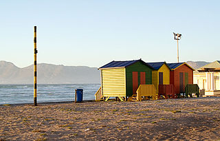
The Cape Metropole has a wide variety of beaches divided into three regions by the Cape Peninsula:
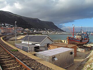
Kalk Bay is a fishing village and suburb of Cape Town. It lies on the east coast of False Bay with much of the town built on the slopes of mountains which border the sea, with peaks of Table Mountain Sandstone forming valleys. The railway from Cape Town to Simon's Town passes through Kalk Bay, which has one station near the harbour.

Cape Town lies at the south-western corner of the continent of Africa. It is bounded to the south and west by the Atlantic Ocean, and to the north and east by various other municipalities in the Western Cape province of South Africa.
The Fish Hoek Valley is situated in the Cape Peninsula, eighteen miles south of Cape Town, South Africa. It takes its name from the town of Fish Hoek on the False Bay coast.

Miller's Point is a headland and stretch of protected coastline in South Africa. It is located about 4 kilometres (2.5 mi) south of Simon's Town on the road to Cape Point.

Green Head is a small Australian coastal town in the Shire of Coorow. The town is situated between Geraldton and Perth in the Mid West region of Western Australia along Indian Ocean Drive. Its beaches and lifestyle provide a relaxed holiday atmosphere. It is the home of what was a significant, but now declining, rock lobster industry.

The Table Mountain National Park Marine Protected Area is an inshore marine protected area around the Cape Peninsula, in the vicinity of Cape Town, South Africa. It was proclaimed in Government Gazette No. 26431 of 4 June 2004 in terms of the Marine Living Resources Act, 18 of 1998.
The Betty's Bay Marine Protected Area is part of the Kogelberg Biosphere Reserve. It is about 29km south-east of Gordon's Bay and approximately 37km north-west of Hermanus on the south-western coast of the Western Cape. It is in the Atlantic Ocean immediately adjacent to the town of Betty's Bay, in the Overstrand Municipal area.
The Helderberg Marine Protected Area is a small marine conservation area on the north-eastern side of False Bay in the Western Cape province of South Africa, It lies between the mouths of the Lourens River in the Strand, and the Eerste River in Macassar.
The Stilbaai Marine Protected Area is an inshore conservation region in the territorial waters near Stilbaai on the south coast of the Western Cape province of South Africa.
The Rocherpan Marine Protected Area is a small coastal conservation region on the West Coast of the Western Cape province, in the territorial waters of South Africa. It is about 25 km north of Velddrif on the road to Elands Bay, north of Dwarskersbos.
The Sixteen Mile Beach Marine Protected Area is a coastal conservation region in the territorial waters of South Africa, near Saldanha Bay on the Western Cape coast. The MPA is part of the West Coast National Park which is the core component of the Cape West Coast Biosphere Reserve. The beach stretches from Yzerfontein's Main Beach to the start of the West Coast National Park.