
Fynbos is a small belt of natural shrubland or heathland vegetation located in the Western Cape and Eastern Cape provinces of South Africa. This area is predominantly coastal and mountainous, with a Mediterranean climate and rainy winters. The fynbos ecoregion is within the Mediterranean forests, woodlands, and scrub biome. In fields related to biogeography, fynbos is known for its exceptional degree of biodiversity and endemism, consisting of about 80% species of the Cape floral kingdom, where nearly 6,000 of them are endemic. This land continues to face severe human-caused threats, but due to the many economic uses of the fynbos, conservation efforts are being made to help restore it.

The Cape Flats is an expansive, low-lying, flat area situated to the southeast of the central business district of Cape Town. The Cape Flats is also the name of an administrative region of the City of Cape Town, which lies within the larger geographical area.

Overberg is a region in South Africa to the east of Cape Town beyond the Hottentots-Holland mountains. It lies along the Western Cape Province's south coast between the Cape Peninsula and the region known as the Garden Route in the east. The boundaries of the Overberg are the Hottentots-Holland mountains in the West; the Riviersonderend Mountains, part of the Cape Fold Belt, in the North; the Atlantic and Indian Oceans in the South and the Breede River in the East.

The Cape Peninsula is a generally mountainous peninsula that juts out into the Atlantic Ocean at the south-western extremity of the African continent. At the southern end of the peninsula are Cape Point and the Cape of Good Hope. On the northern end is Table Mountain, overlooking Table Bay and the City Bowl of Cape Town, South Africa. The peninsula is 52 km long from Mouille point in the north to Cape Point in the south. The Peninsula has been an island on and off for the past 5 million years, as sea levels fell and rose with the ice age and interglacial global warming cycles of, particularly, the Pleistocene. The last time that the Peninsula was an island was about 1.5 million years ago. Soon afterwards it was joined to the mainland by the emergence from the sea of the sandy area now known as the Cape Flats. The towns and villages of the Cape Peninsula and Cape Flats, and the undeveloped land of the rest of the peninsula now form part of the City of Cape Town metropolitan municipality. The Cape Peninsula is bounded to the north by Table Bay, to the west by the open Atlantic Ocean, and to the east by False Bay in the south and the Cape Flats in the north.

False Bay is a body of water in the Atlantic Ocean between the mountainous Cape Peninsula and the Hottentots Holland Mountains in the extreme south-west of South Africa. The mouth of the bay faces south and is demarcated by Cape Point to the west and Cape Hangklip to the east. The north side of the bay is the low-lying Cape Flats, and the east side is the foot of the Hottentots Holland Mountains to Cape Hangklip which is at nearly the same latitude as Cape Point. In plan the bay is approximately square, being roughly the same extent from north to south as east to west, with the southern side open to the ocean. The seabed slopes gradually down from north to south, and is mostly fairly flat unconsolidated sediments. Much of the bay is off the coast of the City of Cape Town, and it includes part of the Table Mountain National Park Marine Protected Area and the whole of the Helderberg Marine Protected Area. The name "False Bay" was applied at least three hundred years ago by sailors returning from the east who confused Cape Point and Cape Hangklip, which are somewhat similar in profile when approached from the southeast.
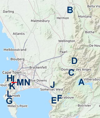
The Cape Metropole has a wide variety of beaches divided into three regions by the Cape Peninsula:

Helderberg refers to a planning district of the City of Cape Town metropolitan municipality, the mountain after which it is named, a wine-producing area in the Western Cape province of South Africa, or a small census area in Somerset West.

The Hottentots Holland Mountains are part of the Cape Fold Belt in the Western Cape, South Africa. The mountain range forms a barrier between the Cape Town metropolitan area and the southern Overberg coast.

The Steenbras Dam, now referred to as Steenbras Lower Dam, is a gravity concrete arch type dam located in the Hottentots-Holland mountains, above Gordons Bay, near Cape Town in South Africa. It is one of the six large dams that make up the Western Cape Water Supply System. It is owned by the City of Cape Town and serves principally to supply water to that city. The dam wall is 28 metres (92 ft) high and 412 metres (1,352 ft) long; it impounds a reservoir of 36,133 megalitres over a surface area of 380 hectares when full.

Cape Town lies at the south-western corner of the continent of Africa. It is bounded to the south and west by the Atlantic Ocean, and to the north and east by various other municipalities in the Western Cape province of South Africa.
The Western Cape Water Supply System (WCWSS) is a complex water supply system in the Western Cape region of South Africa, comprising an inter-linked system of six main dams, pipelines, tunnels and distribution networks, and a number of minor dams, some owned and operated by the Department of Water and Sanitation and some by the City of Cape Town.

Wemmershoek Dam is a rock-fill type dam located on the Wemmershoek River near Franschhoek and Paarl in South Africa. It was constructed between 1953 and 1957 on behalf of the City of Cape Town. With a reservoir capacity of 58,644 megalitres, it provides approximately 6.5% of the storage capacity of the Western Cape Water Supply System which supplies Cape Town and surrounding areas.

The Eerste River, located in the Western Cape, South Africa, rises on Dwarsberg 60 km east of Cape Town at the head of Jonkershoek valley. The Eerste River catchment covers the eastern part of the Cape Flats lying to the west of the Hottentots Holland Mountains and south of the Tygerberg where the Kuils River tributary rises east of Kanonkop. The Eerste River is a short river; its length has been given as 40 km. The major tributary, Kuils River, is approximately 30 km long to its point of confluence with the Eerste River.

Steenbras Upper Dam is an earth-fill type dam located in the Hottentots Holland Mountains above Gordons Bay in the Western Cape, South Africa. It impounds the Steenbras River upstream of the older Steenbras Dam. The dam was constructed in 1977 for the City of Cape Town and serves mainly for municipal and industrial use. The hazard potential of the dam has been ranked high (3).

Kogelberg Sandstone Fynbos is a critically endangered vegetation type occurring in the far south of the Western Cape, South Africa.
Kogelberg Nature Reserve is a nature reserve of 3,000 ha comprising the Kogelberg Mountain Range, to the east of Cape Town, South Africa.

Cecilia is a section of the Table Mountain National Park on the lower eastern slopes of Table Mountain in Cape Town, located just to the south of Kirstenbosch National Botanical Garden. It was previously used for commercial logging and known as Cecilia Forest or Cecilia Plantation, but has now been given protected status and integrated into the National Park.
Diastella thymelaeoides is a flower-bearing shrub that belongs to the genus Diastella and forms part of the fynbos. The plant is native to the Western Cape and occurs in the Hottentots Holland Mountains and northern Kogelberg around the Steenbras Dam. The shrub grows upright and grows only 1.5 m tall and flowers throughout the year with a peak from August to November.
Diastella thymelaeoides subsp. thymelaeoides, the Kogelberg silkypuff, is a subspecies of Diastella thymelaeoides that belongs to the genus Diastella and forms part of the fynbos. The plant is native to the Western Cape and occurs in the Hottentots Holland Mountains and northern Kogelberg around the Steenbras Dam. The shrub grows erect and grows only 1.5 m tall and flowers throughout the year with a peak from August to November.
