The Taum Sauk pumped storage plant is a power station in the St. Francois mountain region of Missouri, United States about 90 miles (140 km) south of St. Louis near Lesterville, Missouri, in Reynolds County. It is operated by Ameren Missouri.

The Palmiet Pumped Storage Scheme consists of two 200 megawatts (270,000 hp) turbine units located 2 kilometres (1.2 mi) upstream of the Kogelberg Dam on the Palmiet River near Cape Town, South Africa. The pumped-storage hydroelectricity plant is capable of responding to a surge in peak power demand in minutes. At night, excess power on the grid generated by conventional coal and nuclear plants is used to pump water to the upper Rockview Dam overlooking Gordon's Bay.

Nagarjuna Sagar Dam is a masonry dam across the Krishna River at Nagarjuna Sagar which straddles the border between Palnadu district in Andhra Pradesh and Nalgonda district in Telangana. The dam provides irrigation water to the districts of Palnadu, Guntur, Nalgonda, Prakasam, Khammam, Krishna, and parts of West Godavari. It is also a source of electricity generation for the national grid.

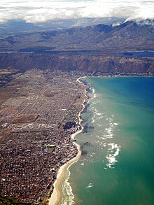
Gordon's Bay is a harbour town in the Western Cape province of South Africa. It is included in the City of Cape Town metropolitan municipality as a suburb of the Helderberg region. It is situated on the shores of Gordon's Bay in the northeastern corner of False Bay about 58 km from Cape Town to the south of the N2 national road and is named after Robert Jacob Gordon (1743–1795), the Dutch explorer of Scottish descent.
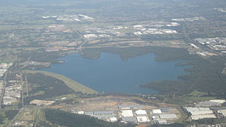
The Prospect Reservoir is a heritage-listed 50,200-megalitre potable water supply and storage reservoir created by the Prospect Dam, across the Prospect Creek located in the Western Sydney suburb of Prospect, in New South Wales, Australia. The eastern bounds of the reservoir are a recreational area and the western periphery are within the bounds of Western Sydney Parklands. It was added to the New South Wales State Heritage Register on 18 November 1999.

Tantangara Dam is a major ungated concrete gravity dam with concrete chute spillway across the Murrumbidgee River in Tantangara, upstream of Adaminaby in the Snowy Mountains region of New South Wales, Australia. The dam is part of the Snowy Mountains Scheme, a vast hydroelectricity and irrigation complex constructed in south-east Australia between 1949 and 1974 and now run by Snowy Hydro. The purpose of the dam includes water management and conservation, with much of the impounded headwaters diverted to Lake Eucumbene. The impounded reservoir is called Tantangara Reservoir.

The Steenbras Dam, now referred to as Steenbras Lower Dam, is a gravity concrete arch type dam located in the Hottentots-Holland mountains, above Gordons Bay, near Cape Town in South Africa. It is one of the six large dams that make up the Western Cape Water Supply System. It is owned by the City of Cape Town and serves principally to supply water to that city. The dam wall is 28 metres (92 ft) high and 412 metres (1,352 ft) long; it impounds a reservoir of 36,133 megalitres over a surface area of 380 hectares when full.

The Sterkfontein Dam, located just outside the town of Harrismith, in the Free State, province of South Africa, is part of the Tugela-Vaal Water Project and the Drakensberg Pumped Storage Scheme, and located on the Nuwejaarspruit, a tributary of the Wilge River in the upper catchment area of the Vaal River. It is the second highest dam wall in South Africa and its highest earth fill dam.
The Ingula Pumped Storage Scheme is a pumped-storage power station in the escarpment of the Little Drakensberg range straddling the border of the KwaZulu-Natal and Free State provinces, South Africa. It is about 22 km (14 mi) North-East of Van Reenen.
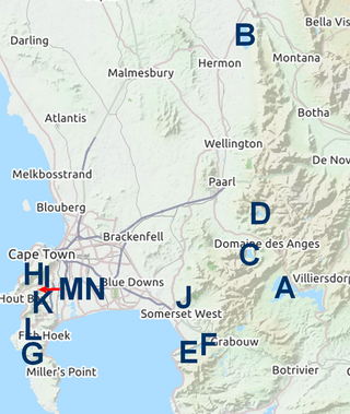
The Western Cape Water Supply System (WCWSS) is a complex water supply system in the Western Cape region of South Africa, comprising an inter-linked system of six main dams, pipelines, tunnels and distribution networks, and a number of minor dams, some owned and operated by the Department of Water and Sanitation and some by the City of Cape Town.

The Berg River Dam is a 68-metre (223 ft) high dam on the Berg River in South Africa. It is the centerpiece of the Berg Water Project (BWP) which is designed to capture the winter rainfall and store it for supply to Cape Town during the dry summer months. The project in turn forms an important part of the Western Cape Water Supply System (WCWSS), an intricate system of dams and bulk water infrastructure that provides water to more than 3 million people. At the inauguration of the dam in 2009, then President of South Africa Kgalema Motlanthe called the project "a good example of how public infrastructure projects can be used to contribute meaningfully to poverty eradication and to foster social empowerment of the people." The Berg River Dam was the first dam in South Africa to be designed and constructed, and is due to be operated, in accordance with the guidelines of the World Commission on Dams. It has been completed on time and within budget. The Berg River basin and the adjacent metropolitan area of Cape Town are of particular importance to the Western Cape region because, although the basin generates only about 3% of the country's water resources, it is home to about 8% of South Africa's population, and produces about 12% of GDP.
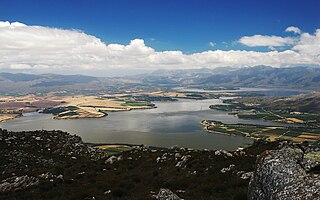
Theewaterskloof Dam is an earth-fill type dam located on the Sonderend River near Villiersdorp, Western Cape, South Africa. Administratively it is located within Theewaterskloof Local Municipality. It was established in 1978 and is the largest dam in the Western Cape Water Supply System with a capacity of 480 million cubic metres, about 41% of the water storage capacity available to Cape Town, which has a population of over 4 million people. The dam mainly serves for municipal and industrial use as well as for irrigation purposes. The hazard potential of the dam has been ranked high (3).
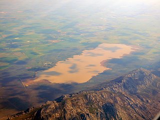
Voëlvlei Dam is a dam located in the Western Cape, South Africa near the town of Gouda. The earth-fill wall is 2,910 metres (9,550 ft) long and 10 metres (33 ft) high. The reservoir covers an area of 1,524 hectares and has a capacity of 168,000 megalitres, making it the second-largest reservoir in the Western Cape Water Supply System. Water from the reservoir is supplied to water treatment works of the City of Cape Town and the West Coast District Municipality, and can also be released into the Berg River for agricultural purposes or to fill the Misverstand Dam.

Wemmershoek Dam is a rock-fill type dam located on the Wemmershoek River near Franschhoek and Paarl in South Africa. It was constructed between 1953 and 1957 on behalf of the City of Cape Town. With a reservoir capacity of 58,644 megalitres, it provides approximately 6.5% of the storage capacity of the Western Cape Water Supply System which supplies Cape Town and surrounding areas.

Woodhead Dam is a dam on Table Mountain, Western Cape, South Africa. It was built in 1897 and supplies water to Cape Town. The dam, which was the first large masonry dam in South Africa, was designated as an International Historic Civil Engineering Landmark by the American Society of Civil Engineers in 2008.

Palmiet River is a river located in the Western Cape province of South Africa. The Palmiet River is a typical Western Cape river, experiencing winter rainfall and it is important for the Western Cape Water Supply System. It has a small catchment area of 500 km2, flows through the expanse of the Elgin Valley, and reaches the ocean through an estuary.
Rockview Dam is a zoned earth-fill/rock-fill type dam located on the Palmiet River near Grabouw, Western Cape, South Africa. It was established in 1986 and serves mainly for pumping purposes (storage). The hazard potential of the dam has been ranked high (3).
The Hex River is a tributary of the Breede River located in the Western Cape of South Africa. The most important settlements along the river are the small towns of De Doorns and Touws River.
The Steenbras Power Station, also Steenbras Hydro Pump Station, is a 180 MW pumped-storage hydroelectric power station commissioned in 1979 in South Africa. The power station sits between the Steenbras Upper Dam and a small lower reservoir on the mountainside below. It acts as an energy storage system, by storing water in the upper reservoir during off-peak hours and releasing that water to generate electricity during peak hours. The City of Cape Town uses the power station for load balancing and to mitigate against loadshedding caused by the South African energy crisis. This power station is reported to be the first pumped-storage hydroelectric power station to be built on the African continent.
