
The Eel River is a major river, about 196 miles (315 km) long, of northwestern California. The river and its tributaries form the third largest watershed entirely in California, draining a rugged area of 3,684 square miles (9,540 km2) in five counties. The river flows generally northward through the Coast Ranges west of the Sacramento Valley, emptying into the Pacific Ocean about 10 miles (16 km) downstream from Fortuna and just south of Humboldt Bay. The river provides groundwater recharge, recreation, and industrial, agricultural and municipal water supply.
Theewaterskloof Municipality is a local municipality located within the Overberg District Municipality, in the Western Cape province of South Africa. As of 2007, the population was 108,790. Its municipality code is WC031. The enormous Theewaterskloof Dam, which provides water for Cape Town and the surrounding areas, is located in this municipality.

The Umgeni River or Mgeni River is a river in KwaZulu-Natal, South Africa. It rises in the "Dargle" in the KZN Midlands, and its mouth is at Durban, some distance north of Durban's natural harbour. It is generally agreed its name means "the river of entrance" in Zulu, though other meanings have been suggested.

The Berg River is a river located just north of Cape Town in the Western Cape Province of South Africa. It is approximately 294 km (183 mi) long with a catchment area of 7,715 km² (2979 mi²) and debouches into the Atlantic Ocean. About 65% of the Berg River area is under agriculture. The major towns in the Berg River area are Velddrif and Laaiplek near the coast, Piketberg, Hopefield, Moorreesburg and Darling further inland.

The Umfolozi River is a river in KwaZulu-Natal, a province of South Africa. It is formed by the confluence of the Black and White Umfolozi Rivers near the southeastern boundary of the Hluhluwe-Umfolozi Game Reserve. The isiZulu name imFolozi is generally considered to describe the zigzag course followed by both tributaries, though other explanations have been given.

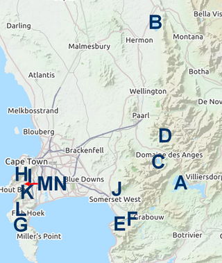
The Palmiet Pumped Storage Scheme consists of two 200 megawatts (270,000 hp) turbine units located 2 kilometres (1.2 mi) upstream of the Kogelberg Dam on the Palmiet River near Cape Town, South Africa. The pumped-storage hydroelectricity plant is capable of responding to a surge in peak power demand in minutes. At night, excess power on the grid generated by conventional coal and nuclear plants is used to pump water to the upper Rockview Dam overlooking Gordon's Bay.

Elgin is a large, lush area of land, circled by mountains, in the Overberg region of South Africa. This broad upland valley lies about 70 km southeast of Cape Town, just beyond the Hottentots Holland Mountains.

Grabouw is a town located in the Western Cape province of South Africa. Grabouw is located some 65 km south-east of Cape Town, over Sir Lowry's Pass from Somerset West, along the N2 highway.The town is the commercial centre for the vast Elgin Valley, the largest single export fruit-producing area in Southern Africa, which extends between the Hottentots-Holland, Kogelberg, Groenland, and Houwhoek Mountains. The town's population has grown rapidly, with 44 593 people in 2019 from 21 593 as listed by the 2001 census.
The Western Cape Water Supply System (WCWSS) is a complex water supply system in the Western Cape region of South Africa, comprising an inter-linked system of six main dams, pipelines, tunnels and distribution networks, and a number of minor dams, some owned and operated by the Department of Water and Sanitation and some by the City of Cape Town.
Kogelberg Dam is a combined gravity & arch type dam located on the Palmiet River, near Grabouw, Western Cape, South Africa. It was established in 1986 and its primary purpose is to serve for irrigation and industrial use. The hazard potential of the dam has been ranked high (3).

Woodhead Dam is a dam on Table Mountain, Western Cape, South Africa. It was built in 1897 and supplies water to Cape Town. The dam, which was the first large masonry dam in South Africa, was designated as an International Historic Civil Engineering Landmark by the American Society of Civil Engineers in 2008.

Gourits River, sometimes spelled 'Gouritz River', is situated in the Western Cape, South Africa.
Bot River is a river in the Western Cape province of South Africa. The river mouth, located at Fisherhaven, Kleinmond is a Ramsar site. Its tributaries include the Swart River. The river falls within the Drainage system G.

Steenbras Upper Dam is an earth-fill type dam located in the Hottentots Holland Mountains above Gordons Bay in the Western Cape, South Africa. It impounds the Steenbras River upstream of the older Steenbras Dam. The dam was constructed in 1977 for the City of Cape Town and serves mainly for municipal and industrial use. The hazard potential of the dam has been ranked high (3).

Mthatha River or Umtata River is a river in the Eastern Cape Province in South Africa. The river flows into the Indian Ocean in an estuary located near Coffee Bay. The Mthatha river flows in a southeastern direction and is approximately 250 km long with a catchment area of 2,600 km2. Mthatha Town (Umtata) is named after it.

The Keiskamma River is a river in the Eastern Cape Province in South Africa. The river flows into the Indian Ocean in the Keiskamma Estuary, located by Hamburg Nature Reserve, near Hamburg, midway between East London and Port Alfred. The Keiskamma flows first in a southwestern and then in a southeastern direction after meeting its main tributary, the Tyhume River.

Krom River or Kromme River is a river in the Eastern Cape Province in South Africa. The river flows into the Indian Ocean through an estuary on the north side of St Francis Bay, west of Port Elizabeth. The Krom river flows in an ESE direction and is approximately 109 km long with a catchment area of 1,085 km2.
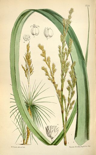
Prionium serratum, the palmiet, is a robust, evergreen, semiaquatic, rhizomatous flowering plant growing to 2 m in height. It is the only species in the genus Prionium, and is endemic to South Africa. Some authors have separated Prionium from the Thurniaceae, putting it instead in its own family, the Prioniaceae.
The Bot River Estuary, also known as the Bot River Lagoon, is part of the Bot-Kleinmond Estuarine System in the Overberg region on the Western Cape of South Africa. It became a Ramsar site wetland in 2017.


