
A beach is a landform alongside a body of water which consists of loose particles. The particles composing a beach are typically made from rock, such as sand, gravel, shingle, pebbles, etc, or biological sources, such as mollusc shells or coralline algae. Sediments settle in different densities and structures, depending on the local wave action and weather, creating different textures, colors and gradients or layers of material.

Cape Charles is a town / municipal corporation in Northampton County, Virginia, United States. The population was 1,009 as of the 2010 U.S.Decennial Census.

The Oregon Coast is a coastal region of the U.S. state of Oregon. It is bordered by the Pacific Ocean to its west and the Oregon Coast Range to the east, and stretches approximately 362 miles (583 km) from the California state border in the south to the Columbia River in the north. The region is not a specific geological, environmental, or political entity, and includes the Columbia River Estuary.

Saco Bay is a small curved embayment of the Gulf of Maine on the Atlantic coast of Maine in the United States. The name derives "from a map of the coastline made in 1525 by the Spanish explorer Esteban Gómez. He named the bay Bahio de Saco ."

Mount's Bay is a large, sweeping bay on the English Channel coast of Cornwall, United Kingdom, stretching from the Lizard Point to Gwennap Head. In the north of the bay, near Marazion, is St Michael's Mount; the origin of name of the bay. In summer, it is a large, benign, scenic, natural harbour. However, in winter, onshore gales present maritime risks, particularly for sailing ships. There are more than 150 known wrecks from the nineteenth century in the area. The eastern side of the bay centred around Marazion and St Michael's Mount was designated as a Marine Conservation Zone in January 2016.
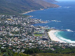
Camps Bay is an affluent suburb of Cape Town, South Africa, and the small bay on the west coast of the Cape Peninsula after which it is named. In summer it attracts many South African and foreign visitors.

False Bay is a body of water in the Atlantic Ocean between the mountainous Cape Peninsula and the Hottentots Holland Mountains in the extreme south-west of South Africa. The mouth of the bay faces south and is demarcated by Cape Point to the west and Cape Hangklip to the east. The north side of the bay is the low-lying Cape Flats. Much of the bay is on the coast of the City of Cape Town, and it includes part of the Table Mountain National Park Marine Protected Area and the whole of the Helderberg Marine Protected Area.

Half Moon Bay State Beach is a 4-mile (6 km) stretch of protected beaches in the state park system of California, United States, on Half Moon Bay. From north to south it comprises Roosevelt, Dunes, Venice, and Francis Beaches. The 181-acre (73 ha) park was established in 1956.

Clifton is an affluent suburb of Cape Town, South Africa. It is an exclusive residential area and is home to the most expensive real estate in South Africa, with dwellings nestled on cliffs that have sweeping views of the Atlantic Ocean.

Milnerton is a seaside suburb on Table Bay and is located north of central Cape Town in South Africa. It is located 11 kilometres to the north of the city's centre.
Chepiwanoxet is a neighborhood in Warwick, Rhode Island, with an island peninsula in Greenwich Bay, an arm of Narragansett Bay. The neighborhood straddles the Amtrak railroad lines, which lies just east of and parallel to the Post Road. Its boundaries are Neptune Street to the North, Alger Avenue to the South, Post Road to the West, and Greenwich Bay to the East. Chepiwanoxet Way, an underpass beneath the Amtrak lines, now serves as the only street access in and out of the neighborhood.
The Fish Hoek Valley is situated in the Cape Peninsula, eighteen miles south of Cape Town, South Africa. It takes its name from the town of Fish Hoek on the False Bay coast.
Camps Bay High School is a school in the Western Cape.
The Table Mountain National Park Marine Protected Area is an inshore marine protected area around the Cape Peninsula, in the vicinity of Cape Town, South Africa. It was proclaimed in Government Gazette No. 26431 of 4 June 2004 in terms of the Marine Living Resources Act, 18 of 1998.

The Betty's Bay Marine Protected Area is part of the Kogelberg Biosphere Reserve. It is about 29 km south-east of Gordon's Bay and approximately 37 km north-west of Hermanus on the south-western coast of the Western Cape. It is in the Atlantic Ocean immediately adjacent to the town of Betty's Bay, in the Overstrand Municipal area.
The Helderberg Marine Protected Area is a small marine conservation area on the north-eastern side of False Bay in the Western Cape province of South Africa, It lies between the mouths of the Lourens River in the Strand, and the Eerste River in Macassar.
The Robben Island Marine Protected Area is an inshore and offshore conservation region around and near Robben Island in Table Bay in the territorial waters of South Africa.
The Jutten Island Marine Protected Area is an inshore conservation region in the territorial waters of South Africa near Saldanha, Western Cape
The Langebaan Lagoon Marine Protected Area is an inshore conservation region in the territorial waters of South Africa
The Malgas Island Marine Protected Area is an inshore conservation region in the territorial waters of South Africa in the entrance to Saldanha Bay on the west coast of the Western Cape province.