
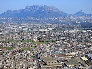
Cape Town is the legislative capital of South Africa. It is the country's oldest city and the seat of the Parliament of South Africa. It is the country's second-largest city, after Johannesburg, and the largest in the Western Cape. The city is part of the City of Cape Town metropolitan municipality.

South Africa occupies the southern tip of Africa, its coastline stretching more than 2,850 kilometres from the desert border with Namibia on the Atlantic (western) coast southwards around the tip of Africa and then northeast to the border with Mozambique on the Indian (eastern) coast. The low-lying coastal zone is narrow for much of that distance, soon giving way to a mountainous escarpment that separates the coast from the high inland plateau. In some places, notably the province of KwaZulu-Natal in the east, a greater distance separates the coast from the escarpment. Although much of the country is classified as semi-arid, it has considerable variation in climate as well as topography. The total land area is 1,220,813 km2 (471,359 sq mi). It has the 23rd largest Exclusive Economic Zone of 1,535,538 km2 (592,875 sq mi).

Great Sankey is a civil parish in the Borough of Warrington, Cheshire, England. It is 2 miles (3.2 km) west of Warrington town centre and had a population of 24,211 in 2001 Census.

The Western Cape is a province of South Africa, situated on the south-western coast of the country. It is the fourth largest of the nine provinces with an area of 129,449 square kilometres (49,981 sq mi), and the third most populous, with an estimated 7 million inhabitants in 2020. About two-thirds of these inhabitants live in the metropolitan area of Cape Town, which is also the provincial capital. The Western Cape was created in 1994 from part of the former Cape Province. The two largest cities are Cape Town and George.

Cape York Peninsula is a peninsula located in Far North Queensland, Australia. It is the largest wilderness in northern Australia. The land is mostly flat and about half of the area is used for grazing cattle. The relatively undisturbed eucalyptus-wooded savannahs, tropical rainforests and other types of habitat are now recognised and preserved for their global environmental significance. Although much of the peninsula remains pristine, with a diverse repertoire of endemic flora and fauna, some of its wildlife may be threatened by industry and overgrazing as well as introduced species and weeds.

Plettenberg Bay, nicknamed Plett, is the primary town of the Bitou Local Municipality in the Western Cape Province of South Africa. According to the census of 2001, the town had a population of 29,149. It was originally named Bahia Formosa by early Portuguese explorers and lies on South Africa's Garden Route 210 km from Port Elizabeth and about 600 km from Cape Town.

Shakotan is a town located in Shiribeshi Subprefecture, Hokkaido, Japan. As of September 2016, the town had a population of 2,215, and a density of 9.3 persons per km2. The total area of the town is 238.20 square kilometres (91.97 sq mi), and located 90 kilometres (56 mi) west of Sapporo, the capital and economic hub of Hokkaido. Shakotan occupies the north of the Shakotan Peninsula. It was founded in 1869 as part of the short-lived Shiribeshi Province, which was dissolved in 1882 to become Hokkaido. Shakotan, along with neighboring Otaru, is home to Japan's only national-level marine sanctuary. Shakotan is home to the three great capes of the Shakotan Peninsula: Kamui, Shakotan, and Ōgon.

Laura is a rural town and locality in the Shire of Cook, Queensland, Australia. In the 2021 census, the locality of Laura had a population of 133 people.

The Cape Peninsula is a generally mountainous peninsula that juts out into the Atlantic Ocean at the south-western extremity of the African continent. At the southern end of the peninsula are Cape Point and the Cape of Good Hope. On the northern end is Table Mountain, overlooking Table Bay and the City Bowl of Cape Town, South Africa. The peninsula is 52 km long from Mouille point in the north to Cape Point in the south. The Peninsula has been an island on and off for the past 5 million years, as sea levels fell and rose with the ice age and interglacial global warming cycles of, particularly, the Pleistocene. The last time that the Peninsula was an island was about 1.5 million years ago. Soon afterwards it was joined to the mainland by the emergence from the sea of the sandy area now known as the Cape Flats. The towns and villages of the Cape Peninsula and Cape Flats, and the undeveloped land of the rest of the peninsula now form part of the City of Cape Town metropolitan municipality. The Cape Peninsula is bounded to the north by Table Bay, to the west by the open Atlantic Ocean, and to the east by False Bay in the south and the Cape Flats in the north.

Gansbaai is a fishing town and tourist destination in the Overberg District Municipality, Western Cape, South Africa. It is known for its dense population of great white sharks and as a whale-watching location.
Cape Peninsula University of Technology is a university in Cape Town, South Africa. It is the only university of technology in the Western Cape province, and is also the largest university in the province, with over 32,000 students. It was formed by merging the Cape Technikon and Peninsula Technikon as well as a few other independent colleges.
Great Sankey High School (GSHS) is a coeducational secondary school and sixth form with academy status, located in Warrington, Cheshire, England. It is a member of the Omega Multi-Academy Trust (OMAT). The school was first built in the 1970s and extensions have included a mathematics & humanities block and theatre. The school also has a linking leisure centre and arts theatre. GSHS has been awarded, and retained, an Artsmark Gold award, the highest award for the Arts.

Wynberg is a upmarket southern suburb of the City of Cape Town in Western Cape, South Africa.It is situated between Constantia,bishopscourt Plumstead and Kenilworth, and is a main transport hub for the Southern Suburbs of Cape Town.It is divided into wynberg village, wynberg upper(west),Trovato estate and lower wynberg(east).

The Southern Suburbs are a group of Anglophone suburbs in Cape Town, Western Cape, South Africa. This group includes, among others, Observatory, Mowbray, Pinelands, Rosebank, Rondebosch, Rondebosch East, Newlands, Claremont, Lansdowne, Kenilworth, Bishopscourt, Constantia, Wynberg, Ottery, Plumstead, Diep River, Bergvliet and Tokai. The area is also commonly referred to as the Cape Peninsula, often including the towns further South such as Fish Hoek.

Parow is a town of Cape Town in the Western Cape, South Africa and a Northern Suburb of the City of Cape Town Metropolitan Municipality founded by Johann Heinrich Ferdinand Parow who arrived in the locality in 1865.
Elsie's River is a suburb of Cape Town, South Africa.
Grassy Park is a suburb of the City of Cape Town in the Western Cape Province of South Africa.
Dozens of fortifications were built in Cape Town and the Cape Peninsula between the 1650s and the 1940s. Most have gone, but a few still stand.

The following outline is provided as an overview of and topical guide to Cape Town:

Mogamad Ganief Ebrahim Hendricks is a South African politician, businessman, lecturer and teacher who is a Member of the National Assembly of South Africa. He became an MP on 22 May 2019. He is the founder and current leader of Al Jama-ah, a party for upholding Muslim interests in South Africa. Hendricks was previously a City of Cape Town municipal councillor. Since 3 July 2024, he serves as Deputy Minister of Social Development of South Africa.
