
Cape Breton Island is an island on the Atlantic coast of North America and part of the province of Nova Scotia, Canada.

Cape Town is the oldest city in South Africa, colloquially named the Mother City. It is the legislative capital of South Africa and primate city of the Western Cape province. It forms part of the City of Cape Town metropolitan municipality.

Cape Cod is a geographic cape extending into the Atlantic Ocean from the southeastern corner of mainland Massachusetts, in the northeastern United States. Its historic, maritime character and ample beaches attract heavy tourism during the summer months.
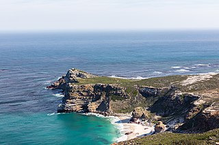
The Cape of Good Hope is a rocky headland on the Atlantic coast of the Cape Peninsula in South Africa.

The Cape of Good Hope, also known as the Cape Colony, was a British colony in present-day South Africa, named after the Cape of Good Hope. The British colony was preceded by an earlier Dutch colony of the same name, the Kaap de Goede Hoop, established in 1652 by the Dutch East India Company. The Cape was under Dutch rule from 1652 to 1795 and again from 1803 to 1806. The Dutch lost the colony to Great Britain following the 1795 Battle of Muizenberg, but had it returned following the 1802 Peace of Amiens. It was re-occupied by the UK following the Battle of Blaauwberg in 1806, and British possession affirmed with the Anglo-Dutch Treaty of 1814.

The Union of South Africa is the historical predecessor to the present-day Republic of South Africa. It came into being on 31 May 1910 with the unification of the Cape Colony, the Natal Colony, the Transvaal, and the Orange River Colony. It included the territories that were formerly a part of the South African Republic and the Orange Free State.
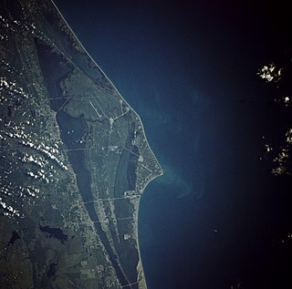
Cape Canaveral, from the Spanish Cabo Cañaveral, is a cape in Brevard County, Florida, United States, near the center of the state's Atlantic coast. Known as Cape Kennedy from 1963 to 1973, it lies east of Merritt Island, separated from it by the Banana River. It was discovered by the Spanish conquistador Juan Ponce de León in 1513.

Cape Coral is a city located in Lee County, Florida, United States, on the Gulf of Mexico. Founded in 1957 and developed as a planned community, the city grew to a population of 154,305 by the year 2010. The city's population estimate was 165,831 for 2013 and 179,804 for 2016. With an area of 120 square miles (310 km2), Cape Coral is the largest city between Tampa and Miami. It is a principal city in the Cape Coral – Fort Myers, Florida Metropolitan Statistical Area. The population estimate for the statistical area was 679,513 for 2014. The city is known as a "Waterfront Wonderland"; with over 400 mi (640 km) of navigable waterways, Cape Coral has more miles of canals than any other city in the world.

Cape Girardeau is a city in Cape Girardeau county in the U.S. state of Missouri. It is located approximately 115 miles (185 km) southeast of St. Louis and 175 miles (282 km) north of Memphis. As of the 2017 United States Census Bureau estimates, the city's population was 39,151, making it the 17th-largest city in Missouri, and the largest city in Southeast Missouri. An emerging college town, it is the home of Southeast Missouri State University.

Coloureds are a multiracial ethnic group native to Southern Africa who have ancestry from more than one of the various populations inhabiting the region, including Khoisan, Bantu, Afrikaner, English, Austronesian, East Asian or South Asian. Because of the combination of ethnicities, different families and individuals within a family may have a variety of different physical features.

Cape Canaveral Air Force Station (CCAFS) is an installation of the United States Air Force Space Command's 45th Space Wing.

The Eastern Cape is a province of South Africa. Its capital is Bhisho, but its two largest cities are Port Elizabeth and East London. It was formed in 1994 out of the Xhosa homelands or bantustans of Transkei and Ciskei, together with the eastern portion of the Cape Province. It is the landing place and home of the 1820 Settlers. The central and eastern part of the province is the traditional home of the Xhosa people.

Jonathan Cape is a London publishing firm founded in 1921 by Herbert Jonathan Cape, who was head of the firm until his death in 1960.

Port Elizabeth or The Bay is one of the major cities in South Africa; it is situated in the Eastern Cape Province, 770 km (478 mi) east of Cape Town. The city, often shortened to PE and nicknamed "The Windy City", stretches for 16 km along Algoa Bay, and is one of the major seaports in South Africa. Port Elizabeth is the southernmost large city on the African continent, just farther south than Cape Town. Port Elizabeth was founded as a town in 1820 to house British settlers as a way of strengthening the border region between the Cape Colony and the Xhosa. It now forms part of the Nelson Mandela Bay Metropolitan Municipality, which has a population of over 1.3 million.

Cape Horn is the southernmost headland of the Tierra del Fuego archipelago of southern Chile, and is located on the small Hornos Island. Although not the most southerly point of South America, Cape Horn marks the northern boundary of the Drake Passage and marks where the Atlantic and Pacific Oceans meet.
A headland is a coastal landform, a point of land usually high and often with a sheer drop, that extends into a body of water. It is a type of promontory. A headland of considerable size often is called a cape. Headlands are characterised by high, breaking waves, rocky shores, intense erosion, and steep sea cliffs.
Afrikaners are a Southern African ethnic group descended from predominantly Dutch settlers first arriving in the 17th and 18th centuries. They traditionally dominated South Africa's agriculture and politics prior to 1994. Afrikaans, South Africa's third most widely spoken home language, is the mother tongue of Afrikaners and most Cape Coloureds. It evolved from the Dutch vernacular of South Holland, incorporating words brought from the Dutch East Indies and Madagascar by slaves. Afrikaners make up approximately 5.2% of the total South African population based on the number of white South Africans who speak Afrikaans as a first language in the South African National Census of 2011.

Cape Verde or Cabo Verde, officially the Republic of Cabo Verde, is an island country spanning an archipelago of 10 volcanic islands in the central Atlantic Ocean. It forms part of the Macaronesia ecoregion, along with the Azores, Canary Islands, Madeira, and the Savage Isles. In ancient times these islands were referred to as "the Islands of the Blessed" or the "Fortunate Isles". Located 570 kilometres (350 mi) west of the Cape Verde Peninsula off the coast of Northwest Africa, the islands cover a combined area of slightly over 4,000 square kilometres (1,500 sq mi).


