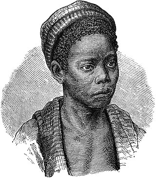
The Tswana are a bantu ethnic group native to Southern Africa. Ethnic Tswana made up approximately 85% of the population of Botswana in 2011.

Wilton is a term archaeologists use to generalize archaeological sites and cultures that share similar stone and non-stone technology dating from 8,000-4,000 years ago. Archaeologists often refer to Wilton as a technocomplex, or Industry. Technological industries are defined by a common tradition of stone tool assemblages, but these technological industries extend to common cultural behaviors. As such, archaeologists use these industries to define a discrete cultural taxonomy. However, technological industries have the potential to generalize different cultures and communities at regional scales that, in more local settings, are distinguishable in both technology and cultural behaviors.

Knysna is a town with 76,150 inhabitants in the Western Cape province of South Africa. It is one of the destinations on the loosely defined Garden Route tourist route. It is situated 60 kilometres east of the city of George on the N2 highway, and 33 kilometres west of the Plettenberg Bay on the same road.
White River is a small holiday and farming town situated just north of Mbombela in Mpumalanga, South Africa. The farms in the region produce tropical fruits, macadamia nuts, vegetables, flowers and timber. As of 2011, White River had a population of 16,639.

Newtown is a suburb of Johannesburg, South Africa. It is located in the capital city of Gauteng Province and in Region F of the City of Johannesburg Metropolitan Municipality. It has the coordinates of 26.204°S and 28.034°E. The suburb originated as a manufacturing district for brick production.
The Kingdom of Mapungubwe was a medieval state in South Africa located at the confluence of the Shashe and Limpopo rivers, south of Great Zimbabwe. The name is derived from either TjiKalanga and Tshivenda. The name might mean "Hill of Jackals" or "stone monuments". The kingdom was the first stage in a development that would culminate in the creation of the Kingdom of Zimbabwe in the 13th century, and with gold trading links to Rhapta and Kilwa Kisiwani on the African east coast. The Kingdom of Mapungubwe lasted about 140 years, and at its height the capital's population was about 5000 people.
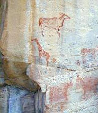
The Tsodilo Hills are a UNESCO World Heritage Site (WHS), consisting of rock art, rock shelters, depressions, and caves in southern Africa. It gained its WHS listing in 2001 because of its unique religious and spiritual significance to local peoples, as well as its unique record of human settlement over many millennia. UNESCO estimates there are over 4500 rock paintings at the site. The site consists of a few main hills known as the Child Hill, Female Hill, and Male Hill.

Swahili architecture is a term used to designate a whole range of diverse building traditions practiced or once practiced along the eastern and southeastern coasts of Africa. Rather than simple derivatives of Islamic architecture from the Arabic world, Swahili stone architecture is a distinct local product as a result of evolving social and religious traditions, environmental changes, and urban development.

The Kurrichane thrush is a species of bird in the thrush family Turdidae. The species is found from central through to southern Africa. Its natural habitat is dry savanna and woodland, predominantly miombo woodland.
The Dzata Ruins, an archaeological site in Dzanani in the Makhado municipality, Vhembe district, in the north of South Africa, is one of the national monuments in South Africa.
Thomas N. Huffman was Professor Emeritus of archaeology in association with the University of Witwatersrand in Johannesburg, South Africa. He specialised in pre-colonial farming societies in southern Africa. Huffman is most well known for his identification of the Central Cattle Pattern at Mapungubwe, a pre-colonial state in southern Africa. This, in turn he argued as the main influence in the formation of the Zimbabwe Pattern at Great Zimbabwe. Arguably his seminal contribution to the field was A Handbook to the Iron Age: The Archaeology of Pre-Colonial Farming Societies in Southern Africa (2007), which has contributed to the understanding of ceramic style analysis and culture history focusing on these groups.

The Blaauboschkraal stone ruins are a provincial heritage site in the Mpumalanga province of South Africa. Its neighbouring town, Emgweyna, is 10 kilometres away. The site was declared a national monument on 18 April 1975 and is a heritage site recognised by the South African Heritage Resources Agency.

Samaria was the capital city of the Kingdom of Israel between c. 880 BCE and c. 720 BCE. It is the namesake of Samaria, a historical region bounded by Judea to the south and by Galilee to the north. After the Assyrian conquest of Israel, Samaria was annexed by the Neo-Assyrian Empire and continued as an administrative centre. It retained this status in the Neo-Babylonian Empire and the Achaemenid Persian Empire before being destroyed during the Wars of Alexander the Great. Later, under the hegemony of the Roman Republic and the subsequent Roman Empire, the city was rebuilt and expanded by the Jewish king Herod the Great, who also fortified it and renamed it "Sebastia" in honour of the Roman emperor Augustus.

Daniëlskuil is a town in ZF Mgcawu District Municipality in the Northern Cape province of South Africa.
Lyn Wadley is an honorary professor of archaeology, and also affiliated jointly with the Archaeology Department and the Institute for Evolution at the University of the Witwatersrand in Johannesburg, South Africa.
Clarence van Riet Lowe was a South African civil engineer and archaeologist. He was appointed by Jan Smuts as the first director of the Bureau of Archaeology and was among the first group to investigate the archaeological site of Mapungubwe.

Thulamela is the most dramatic of around 300 archaeological sites identified in Kruger National Park. It is located on heights south of the Levubu River offering a panoramic view. Sidney Miller led excavations from December 1993 to July 1995, and the site has also been partially reconstructed.
Revil John Mason was a South African archaeologist. He was Professor of Archaeology at the University of the Witwatersrand.
Kweneng’ ruins are the remains of a pre-colonial Tswana capital occupied from the 15th to the 19th century AD in South Africa. The site is located 30km south of the modern-day city of Johannesburg. Settlement at the site likely began around the 1400s and saw its peak in the 15th century. The Kweneng' ruins are similar to those built by other early civilizations found in the southern Africa region during this period, including the Luba–Lunda kingdom, Kingdom of Mutapa, Bokoni, and many others, as these groups share ancestry. Kweneng' was the largest of several sizable settlements inhabited by Tswana speakers prior to European arrival. Several circular stone walled family compounds are spread out over an area 10km long and 2km wide. It is likely that Kweneng' was abandoned in the 1820s during the period of colonial expansion-related civil wars known as the Mfecane or Difaqane, leading to the dispersal of its inhabitants.

The history of Southern Africa has been divided into its prehistory, its ancient history, the major polities flourishing, the colonial period, and the post-colonial period, in which the current nations were formed. Southern Africa is bordered by Central Africa, East Africa, the Atlantic Ocean, the Indian Ocean, and the Sahara Desert. Colonial boundaries are reflected in the modern boundaries between contemporary Southern African states, cutting across ethnic and cultural lines, often dividing single ethnic groups between two or more states.
