KwaMhlanga | |
|---|---|
 KwaMhlanga Crossroads | |
 KwaMhlanga  KwaMhlanga | |
| Coordinates: 25°25′55″S28°42′29″E / 25.432°S 28.708°E | |
| Country | South Africa |
| Province | Mpumalanga |
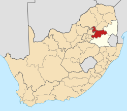
| District | Nkangala |
| Municipality | Thembisile Hani |
| Area | |
• Total | 6.92 km2 (2.67 sq mi) |
| Elevation | 1,325 m (4,347 ft) |
| Population (2021) [1] | |
• Total | 69,853 |
| Racial makeup (2011) | |
| • Black African | 99.0% |
| • Coloured | 0.4% |
| • Indian/Asian | 0.4% |
| • White | 0.2% |
| First languages (2011) | |
| • S. Ndebele | 50.0% |
| • Northern Sotho | 19.7% |
| • Zulu | 10.9% |
| • Sotho | 5.4% |
| • Other | 14.1% |
| Time zone | UTC+2 (SAST) |
| Postal code (street) | 1022 |
| PO box | 1022 |
| Area code | 013 |
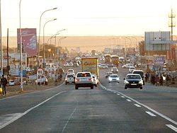
KwaMhlanga is a town in the Nkangala district municipality of the Mpumalanga province in South Africa. It is the spiritual home of the Ndebele tribe that settled here in the early 18th century.
Contents
KwaMhlanga is 73 km or an hour's drive from the country’s capital, Pretoria on the R573 road.
This town developed into the administrative centre for the local government, and now houses the government administration for the North Western Region of the Mpumalanga Province.
To the north of KwaMhlanga, on the R568 road near the village of Klipfontein, is located the Manala Royal Kraal; the Ndzundza Mabhoko Royal Kraal is situated further north at Weltevreden. By special arrangement, both of these kraals can be visited by small groups.