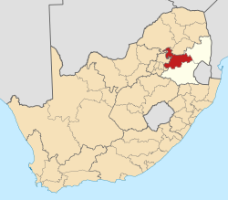
Belfast, Mpumalanga

Last updated
eMakhazeni
Belfast
BergEnDalMemorial.JPG
Battle of Berg-en-dal Memorial south of Belfast.
South Africa Mpumalanga location map.svg
Red pog.svg
eMakhazeni
South Africa adm location map.svg
Red pog.svg
eMakhazeni
Coordinates: 25°41′S30°1′E / 25.683°S 30.017°E / -25.683; 30.017
Country South Africa
Province Mpumalanga
District Nkangala
Municipality Emakhazeni
Area
[1]
  Total35.82 km2 (13.83 sq mi)
Population
 (2011) [1]
  Total4,466
  Density120/km2 (320/sq mi)
Racial makeup (2011)
[1]
   Black African 39.9%
   Coloured 4.4%
   Indian/Asian 2.6%
   White 52.6%
  Other0.5%
First languages (2011)
[1]
   Afrikaans 57.1%
   Zulu 12.3%
   Swazi 7.6%
   English 6.9%
  Other16.0%
Time zone UTC+2 (SAST)
Postal code (street)
1100
PO box
1100
Area code 013

eMakhazeni (formerly known as Belfast) is a small town in Mpumalanga Province, South Africa. It is situated in the eMakhazeni Local Municipality in the Nkangala District Municipality. [2]

Contents

The town is renowned for its excellent trout fishing conditions. Sheep and dairy farming take place here as well as maize, potatoes and timber are produced. Coal and a black granite are mined around Belfast. Around 6 million tulip bulbs are produced here annually for export; the flowers are discarded. Belfast is 2,025m above sea level and one of the coldest and highest towns in South Africa.

Etymology

The town was named after Richard Charles O'Neil from Belfast, Northern Ireland, who owned the farm on which the town was built.

History

Anglo-Boer War

The Second Boer War, 1899-1902. Train, full of probably Boer refugees, at a British Army camp at Belfast. Telfer-dunbar J Q72488.jpg
The Second Boer War, 1899-1902. Train, full of probably Boer refugees, at a British Army camp at Belfast.

During the Anglo-Boer War several battles and skirmishes took place in and around the town. The Battle of Leliefontein took place 30 km south of here at the Komati river, an engagement for which several Victoria Crosses were awarded to Canadian soldiers. The British built a concentration camp here during the Boer War to house Boer women and children. Several Victoria Crosses were awarded for action at Monument Hill which is on the edge of the town. [3] During the war Meyer de Kock and his family resided in town. He was a member of the local peace committee and visited the Boer commandos to persuade them to surrender. He was convicted by them of high treason and executed by firing squad on 12 February 1901. [4]

The Battle of Bergendal took place along the railway line east of the town Belfast in what was then the South African Republic. It lasted from 21 to 27 August 1900. The 7,000 Boers were under the command of General Louis Botha, whose headquarters were at a railway station called Dalmanutha. [5] The 19,000 British Empire forces were under the overall command of Lord Roberts. General Sir Redvers Buller led the final assault against the Boer position on the farm Berg-en-dal (Hill-and-dale).

Geography

Climate

Belfast has a subtropical highland climate (Cwb, according to the Köppen climate classification), with mild summers and chilly, dry winters. The average annual precipitation is 674 mm (27 in), with most rainfall occurring mainly during summer.

Climate data for Belfast, Mpumalanga (1961–1990)
MonthJanFebMarAprMayJunJulAugSepOctNovDecYear
Record high °C (°F)31
(88)
30
(86)
28
(82)
30
(86)
25
(77)
24
(75)
26
(79)
26
(79)
31
(88)
32
(90)
31
(88)
31
(88)
32
(90)
Mean daily maximum °C (°F)23
(73)
22
(72)
22
(72)
20
(68)
18
(64)
15
(59)
16
(61)
18
(64)
22
(72)
22
(72)
22
(72)
23
(73)
20
(68)
Mean daily minimum °C (°F)12
(54)
12
(54)
11
(52)
8
(46)
4
(39)
1
(34)
1
(34)
3
(37)
6
(43)
8
(46)
10
(50)
11
(52)
7
(45)
Record low °C (°F)1
(34)
1
(34)
0
(32)
−3
(27)
−4
(25)
−7
(19)
−6
(21)
−8
(18)
−4
(25)
−3
(27)
1
(34)
2
(36)
−8
(18)
Average precipitation mm (inches)170
(6.7)
101
(4.0)
83
(3.3)
53
(2.1)
16
(0.6)
7
(0.3)
5
(0.2)
9
(0.4)
33
(1.3)
93
(3.7)
156
(6.1)
152
(6.0)
878
(34.6)
Average precipitation days (≥ 1.0 mm)131096311239131383
Source: South African Weather Service [6]

Infrastructure

This city has a railway station for the loading and unloading of passengers and cargo on the Pretoria–Maputo railway. [7] [8]

See also

Related Research Articles

<span class="mw-page-title-main">Second Boer War</span> 1899–1902 war in South Africa

The Second Boer War, also known as the Boer War, Anglo–Boer War, or South African War, was a conflict fought between the British Empire and the two Boer republics over the Empire's influence in Southern Africa.

<span class="mw-page-title-main">Mpumalanga</span> Province in South Africa

Mpumalanga is a province of South Africa. The name means "East", or literally "The Place Where the Sun Rises" in the Nguni languages. Mpumalanga lies in eastern South Africa, bordering Eswatini and Mozambique. It shares borders with the South African provinces of Limpopo to the north, Gauteng to the west, the Free State to the southwest, and KwaZulu-Natal to the south. The capital is Mbombela.

<span class="mw-page-title-main">Mbombela</span> City in Mpumalanga, South Africa

Mbombela, formerly Nelspruit, is a city in northeastern South Africa. It is the capital and the largest city of the Mpumalanga province. Located on the Crocodile River, The city lies about 110 km (68 mi) by road west of the Mozambique border, 330 km (210 mi) east of Johannesburg and 82 km (51 mi) north of the Eswatini border. The city was one of the host cities of the 2010 FIFA World Cup.

<span class="mw-page-title-main">Hampden Zane Churchill Cockburn</span> Recipient of the Victoria Cross

Hampden Zane Churchill Cockburn was a Canadian soldier, and recipient of the Victoria Cross, the most prestigious award for gallantry in the face of the enemy that can be awarded to British and Commonwealth forces.

<span class="mw-page-title-main">Lydenburg</span> Place in Mpumalanga, South Africa

Lydenburg, also known as Mashishing, is a town in Thaba Chweu Local Municipality, on the Mpumalanga highveld, South Africa. It is situated on the Sterkspruit/Dorps River tributary of the Lepelle River at the summit of the Long Tom Pass. It has a long, rich history, ranging from AD 500 to the present. The name is derived from the Dutch Lijdenburg, or "Town of Suffering", and is named for the experiences of the white settlers. In Northern Sotho, Mashishing means "long green grass." Lydenburg has become the centre of the South African fly-fishing industry and is an agricultural, tourism and mining hub.

<span class="mw-page-title-main">Witbank</span> City in Mpumalanga, South Africa

Witbank, officially Emalahleni, is a city situated on the Highveld of Mpumalanga, South Africa, within the Emalahleni Local Municipality. The name Witbank is Afrikaans for "white ridge", and is named after a white sandstone outcrop where wagon transport drivers rested. The city is known for its coal-mining in the surrounding region.

<span class="mw-page-title-main">Dullstroom</span> Place in Mpumalanga, South Africa

Dullstroom, also known as Emnothweni, is a small town in Mpumalanga province, South Africa. The town lies 35 kilometres north of Belfast and some 53 kilometres south-west of Lydenburg on the R540 road.

<span class="mw-page-title-main">Machadodorp</span> Place in Mpumalanga, South Africa

Machadodorp, also known by its official name eNtokozweni, is a small town situated on the N4 road, near the edge of the escarpment in the Mpumalanga province, South Africa. The Elands River runs through the town. There is a natural radioactive spring here that is reputed to have powerful healing qualities.

<span class="mw-page-title-main">Waterval Onder</span> Place in Mpumalanga, South Africa

Waterval Onder is a small village situated at the base of the escarpment on the banks of the Elands River in Emakhazeni Local Municipality, Mpumalanga, South Africa.

<span class="mw-page-title-main">Ermelo, South Africa</span> Place in Mpumalanga, South Africa

Ermelo is the educational, industrial and commercial town of the 7,750 km2 Gert Sibande District Municipality in Mpumalanga province, Republic of South Africa. It is both a mixed agriculture and mining region. It is located 210 km east of Johannesburg.

<span class="mw-page-title-main">Middelburg, Mpumalanga</span> Town in Mpumalanga, South Africa

Middelburg is a large farming and industrial town in the South African province of Mpumalanga.

<span class="mw-page-title-main">Komatipoort</span> Town in Mpumalanga, South Africa

Komatipoort is a town situated at the confluence of the Crocodile and Komati Rivers in Mpumalanga province, South Africa. The town is 8 km from the Crocodile Bridge Gate into the Kruger Park, and just 5 km from the Mozambique border and 65 km from the Eswatini border.

Lichtenburg is a town situated in North West Province, South Africa. It is the administrative centre of Ditsobotla Local Municipality.

The following lists events that happened during 1900 in South Africa.

<span class="mw-page-title-main">Komati River</span> River in Eswatini, Mozambique

The Komati River, also known as the Inkomati River or Incomati River, is a river in South Africa, Eswatini and Mozambique. Originating in north-western Eswatini, it is joined by the Crocodile River in the Lebombo Mountains, enters far south-western Mozambique below the border town of Komatipoort, and enters the Indian Ocean around 24 km (15 mi) north-east of Maputo.

<span class="mw-page-title-main">Battle of Leliefontein</span> 1900 battle of the Second Boer War

The Battle of Leliefontein was an engagement between British-Canadian and Boer forces during the Second Boer War on 7 November 1900, at the Komati River 30 kilometres (19 mi) south of Belfast at the present day Nooitgedacht Dam.

<span class="mw-page-title-main">Battle of Bergendal</span> 1900 battle of the Second Boer War

The Battle of Berg-en-dal took place in South Africa during the Second Anglo-Boer War.

<span class="mw-page-title-main">155 mm Creusot Long Tom</span> Siege gun

The 155 mm CreusotLong Tom was a French siege gun manufactured by Schneider et Cie in Le Creusot, France and used by the Boers in the Second Boer War as field guns.

<span class="mw-page-title-main">Belfast Commando</span> Military unit

Belfast Commando was a light infantry regiment of the South African Army. It formed part of the South African Army Infantry Formation as well as the South African Territorial Reserve.

<span class="mw-page-title-main">Middelburg Commando</span> Military unit

Middelburg Commando was a light infantry regiment of the South African Army. It formed part of the South African Army Infantry Formation as well as the South African Territorial Reserve.

References

  1. 1 2 3 4 "Sub Place Belfast". Census 2011.
  2. "Emakhazeni Local Municipality - Overview".
  3. The Great Boer War by Arthur Conan Doyle, Chapter 33
  4. Albert Blake, Boereverraaier, Tafelberg, 2010, p. 140 to 152.
  5. Viljoen, Ben J., My Reminiscences of the Anglo-Boer War, Kindle edition, location 1285
  6. "Climate data for Belfast". South African Weather Service. Archived from the original on 9 September 2011. Retrieved 19 November 2016.
  7. Mozambique Logistics Infrastructure: Mozambique Railway Assessment Archived 2021-08-02 at the Wayback Machine . Atlassian Confluence. 10 de dezembro de 2018.
  8. "The seven-year long construction of Delagoa Bay railway line starts". South African History Online. Archived from the original on 2013-12-30. Retrieved 2014-06-24.