Wolwekraal

Last updated

Wolwekraal
South Africa Mpumalanga location map.svg
Red pog.svg
Wolwekraal
South Africa adm location map.svg
Red pog.svg
Wolwekraal
Coordinates: 25°09′11″S28°57′40″E / 25.153°S 28.961°E
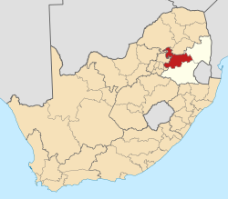
 / -25.153; 28.961
Country South Africa
Province Mpumalanga
District Nkangala
Municipality Dr JS Moroka
Area
[1]
  Total
4.88 km2 (1.88 sq mi)
Population
 (2011) [1]
  Total
7,426
  Density1,500/km2 (3,900/sq mi)
Racial makeup (2011)
[1]
   Black African 99.4%
   Indian/Asian 0.2%
   White 0.3%
  Other0.1%
First languages (2011)
[1]
   S. Ndebele 72.6%
   Northern Sotho 15.7%
   Sotho 3.5%
   Zulu 2.5%
  Other5.8%
Time zone UTC+2 (SAST)

Wolwekraal (also known as Maphotla) is a settlement in Dr JS Moroka Local Municipality in the Mpumalanga province of South Africa.

Contents

Demographics

There is almost 75% of Ndebele & 38% of Sepedi, and also 5.8% for other Languages.

The following statistics are from the 2001 census.

LanguagePopulation%
IsiNdebele 319 92031.35%
IsiZulu 232 22822.75%
Sepedi 161 33815.81%
Afrikaans 75 2947.38%
SiSwati 56 4965.54%
Setswana 56 1445.50%
Sesotho 42 4744.16%
Xitsonga 31 6243.10%
IsiXhosa 21 1992.08%
English 17 7051.73%
Other 3 5140.34%
Tshivenda 2 6540.26%

Gender

GenderPopulation%
Female529 35451.87%
Male491 23848.13%

Ethnic group

Ethnic groupPopulation%
Black African930 87391.21%
White78 2927.67%
Coloured8 7410.86%
Indian/Asian2 6860.26%

Age

AgePopulation%
0–4108 08710.59%
4–9114 03711.17%
10–14118 59011.62%
15–19118 04111.57%
20–2498 4299.64%
25–2988 1068.63%
30–3474 0847.26%
35–3969 4426.80%
40–4458 2515.71%
45–4947 9034.69%
50–5435 3593.46%
55–5925 0132.45%
60–6420 5502.01%
65–6914 3141.40%
70–7412 7821.25%
75–797 3020.72%
80–846 3440.62%
85–892 2730.22%
90–941 0800.11%
95–994200.04%
100 and over1850.02%

References

  1. 1 2 3 4 "Main Place Wolwekraal". Census 2011.