Siyabuswa

Last updated

Siyabuswa
South Africa Mpumalanga location map.svg
Red pog.svg
Siyabuswa
South Africa adm location map.svg
Red pog.svg
Siyabuswa
Coordinates: 25°7′S29°3′E / 25.117°S 29.050°E
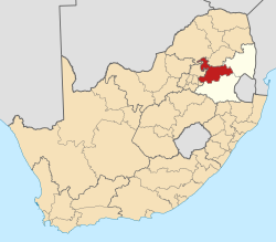
 / -25.117; 29.050
Country South Africa
Province Mpumalanga
District Nkangala
Municipality Dr JS Moroka
Area
[1]
  Total14.88 km2 (5.75 sq mi)
Population
 (2011) [1]
  Total36,882
  Density2,500/km2 (6,400/sq mi)
Racial makeup (2011)
[1]
   Black African 99.5%
   Coloured 0.1%
   Indian/Asian 0.3%
  Other0.1%
First languages (2011)
[1]
   S. Ndebele 71.2%
   Northern Sotho 11.3%
   Zulu 6.7%
   Sotho 2.9%
  Other7.9%
Time zone UTC+2 (SAST)
Postal code (street)
0472
PO box
0472
Area code 013
Website https://www.siyabuswa.co.za/

Siyabuswa is a township in South Africa in the province of Mpumalanga (a region formerly called Eastern Transvaal). During the Apartheid era, Siyabuswa was the capital of the KwaNdebele Bantustan. [2] It served as a capital from 1981 to 1986 when KwaMhlanga replaced it. Most of its inhabitants (population in 2011: 36,882) are members of the Ndebele ethnic group. Currently, Siyabuswa is home to several ethnic groups, namely the Ndebele, Pedi and Sotho people. [3]

Contents

Transport

The town is about 20 kilometers southwest of the Marble Hall airport. The R573 regional route (also known as the Moloto road) that links Pretoria and KwaMhlanga with Marble Hall passes through Siyabuswa.

See also

Related Research Articles

<span class="mw-page-title-main">Southern Ndebele language</span> Language belonging to the Nguni group

isiNdebele, also known as Southern Ndebele or isiNdebele sakwaNdzundza noManala, is an African language belonging to the Nguni group of Bantu languages, spoken by the Ndebele people of South Africa.

<span class="mw-page-title-main">KwaZulu-Natal</span> Province in South Africa

KwaZulu-Natal is a province of South Africa that was created in 1994 when the Zulu bantustan of KwaZulu and Natal Province were merged. It is located in the southeast of the country, with a long shoreline on the Indian Ocean and sharing borders with three other provinces and the countries of Mozambique, Eswatini and Lesotho. Its capital is Pietermaritzburg, and its largest city is Durban. It is the second-most populous province in South Africa, with slightly fewer residents than Gauteng.

<span class="mw-page-title-main">Mpumalanga</span> Province in South Africa

Mpumalanga is a province of South Africa. The name means "East", or literally "The Place Where the Sun Rises" in the Nguni languages. Mpumalanga lies in eastern South Africa, bordering Eswatini and Mozambique. It shares borders with the South African provinces of Limpopo to the north, Gauteng to the west, the Free State to the southwest, and KwaZulu-Natal to the south. The capital is Mbombela.

<span class="mw-page-title-main">Pan Africanist Congress of Azania</span> Political party in South Africa

The Pan Africanist Congress of Azania is a South African national liberation Pan-Africanist movement that is now a political party. It was founded by an Africanist group, led by Robert Sobukwe, that broke away from the African National Congress (ANC) in 1959, as the PAC objected to the ANC's "the land belongs to all who live in it both white and black" and also rejected a multiracialist worldview, instead advocating a South Africa based on African nationalism.

<span class="mw-page-title-main">KwaMhlanga</span> Place in Mpumalanga, South Africa

KwaMhlanga is a town in the Nkangala district municipality of the Mpumalanga province in South Africa. It is the spiritual home of the Ndebele tribe that settled here in the early 18th century. Kwamhlanga now consists of Kwamhlanga, Mandela, Phola, Sun City, Lithuli, Jordan, Mountain View, eMpumelelweni Village, Kingspark Village, and Tweefontein.

<span class="mw-page-title-main">KwaNdebele</span> Former bantustan in South Africa

KwaNdebele was a bantustan in South Africa, intended by the apartheid government as a semi-independent homeland for the Ndebele people. The homeland was created when the South African government purchased nineteen white-owned farms and installed a government.

The Northern Ndebele people are a Nguni ethnic group native to Southern Africa. Significant populations of native speakers of the Northern Ndebele language (siNdebele) are found in Zimbabwe and in South Africa.

<span class="mw-page-title-main">Vaalbank</span> Place in Mpumalanga, South Africa

Vaalbank is a small town some 102 kilometers northeast of Pretoria. The town is an important one in Mpumalanga's northwestern end where the majority of the surrounding population is rural and does not have infrastructure. It overlooks the Mkhombo Dam which is of agricultural importance in the region.

uMhlanga, KwaZulu-Natal Place in KwaZulu-Natal, South Africa

uMhlanga, alternatively rendered Umhlanga, is a residential, commercial and resort town north of Durban on the coast of KwaZulu-Natal, South Africa. It is part of the eThekwini Metropolitan Municipality, which was created in 2000 and includes the greater Durban area. The name means "place of reeds" in the Zulu language, and the correct pronunciation of "hl" in uMhlanga is similar to the Welsh "ll".

<span class="mw-page-title-main">Nguni people</span> Southern African Bantu cultural group

The Nguni people are a linguistic cultural group that migrated to South Africa, made up of Bantu ethnic groups from central Africa, with offshoots in neighboring countries in Southern Africa. Swazi people live in both South Africa and Eswatini, while Ndebele people live in both South Africa and Zimbabwe.

La Lucia is a wealthy suburb located in uMhlanga in the KwaZulu-Natal province of South Africa and is situated approximately 14 kilometres north of the Durban CBD. It was named after Lucia Michel. She and her husband Albert Michel founded the sugar cane farm La Lucia.

<span class="mw-page-title-main">Southern Ndebele people</span> Ethnic group native to South Africa

AmaNdebele are an ethnic group native to South Africa who speak isiNdebele. They mainly inhabit the provinces of Mpumalanga, Gauteng and Limpopo, all of which are in the northeast of the country. In academia this ethnic group is referred to as the Southern Ndebele to differentiate it from their relatives the Northern Ndebele people of Limpopo and Northwest.

<span class="mw-page-title-main">KwaZulu-Natal Sharks Board</span>

The KwaZulu-Natal Sharks Board (KZNSB), previously the Natal Sharks Board and Natal Anti-Shark Measures Board is an organisation that maintains a "shark control" program off the coast of KwaZulu-Natal Province, South Africa, at 37 places. The purpose of the nets and drum lines is to reduce the number of shark attacks. It was founded as a statutory body in 1962, when the city of Durban's netting operations were extended to other parts of the coast in the then Natal Province. It is headquartered in uMhlanga, north of Durban.

Kameel-rivier B or Kameelrivier is a village in the low-veld region of KwaNdebele, in the Nkangala District Municipality of the Mpumalanga province of South Africa. The majority of the residents are from the Ndebele people and Sepedi-speaking people. Siyabuswa is its main town. Main family clans include Napo, Masilela, Ramushu, Mahlangu and Skhosana clans.

The R513 is a Regional Route in South Africa that connects Hartbeespoort with Bronkhorstspruit via Akasia, Pretoria North and Cullinan.

<span class="mw-page-title-main">R568 (South Africa)</span>

The R568 is a Regional Route in South Africa that connects Siyabuswa with Bronkhorstspruit via KwaMhlanga.

The R573 is a Regional Route in South Africa that connects Pretoria with Marble Hall via KwaMhlanga and Siyabuswa. As the road passes through Moloto, the entire route is known as the Moloto Road. It is maintained by the South African National Roads Agency.

<span class="mw-page-title-main">115 Battalion</span> Military unit

115 South African Infantry Battalion was a motorised infantry unit of the South African Army.

Before 1994, South Africa had only four provinces: Cape Province, Natal Province, Orange Free State and Transvaal. Each province had its own identifying lettering: Cape – C, Natal – N, Orange Free State – O and Transvaal – T.

References

  1. 1 2 3 4 "Main Place Siyabuswa". Census 2011.
  2. https://wiredspace.wits.ac.za/server/api/core/bitstreams/8bb84680-f79d-4749-9b3a-3b625f2fc9ea/content
  3. https://journals.co.za/doi/pdf/10.10520/AJA0259188X_672