This article relies largely or entirely on a single source .(June 2024) |
Kwaggafontein | |
|---|---|
| Ekukhanyeni | |
 Kwaggafontein  Kwaggafontein | |
| Coordinates: 25°18′27″S28°56′49″E / 25.3075°S 28.9469°E | |
| Country | South Africa |
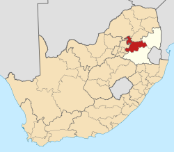
| Province | Mpumalanga |
| District | Nkangala |
| Municipality | Thembisile Hani |
| Area | |
• Total | 17.84 km2 (6.89 sq mi) |
| Population (2011) [1] | |
• Total | 45,104 |
| Racial makeup (2011) | |
| • Black African | 98.9% |
| • Indian/Asian | 0.54% |
| • Coloured | 0.32% |
| • White | 0.09% |
| • Other | 0.15% |
| First languages (2011) | |
| • S. Ndebele | 69.89% |
| • Zulu | 13.4% |
| • Northern Sotho | 4.01% |
| • Sotho | 3.10% |
| • Other | 9.6% |
| Time zone | UTC+2 (SAST) |
| Postal code (street) | 0458 |
Kwaggafontein, officially Ekukhanyeni, [2] [3] [4] is a town along the Moloto Road (R573) in the Thembisile Hani Local Municipality of the Nkangala District Municipality, which is located in the Mpumalanga province of South Africa. It was established in the late 1940s by the AmaNdebele tribe of South Africa. The Ndebele people who currently occupy the town came from nearby farms that are today in the Mpumalanga and Gauteng provinces. Many people came from current day Bronkhorstspruit, Delmas, Balmoral and other surrounding areas.
It is a modern, civilised area consisting of schools, Kwagga Mall (formerly Kwagga Plaza), and a market.[ citation needed ] There is also a Marble Mine nearby currently producing limestones as concrete crushed slabs currently operating around the clock.[ citation needed ]