Mpumalanga is a province of South Africa. The name means "East", or literally "The Place Where the Sun Rises" in the Nguni languages. Mpumalanga lies in eastern South Africa, bordering Eswatini and Mozambique. It shares borders with the South African provinces of Limpopo to the north, Gauteng to the west, the Free State to the southwest, and KwaZulu-Natal to the south. The capital is Mbombela.

Mbombela, formerly Nelspruit, is a city in northeastern South Africa. It is the capital and the largest city of the Mpumalanga province. Located on the Crocodile River, The city lies about 110 km (68 mi) by road west of the Mozambique border, 330 km (210 mi) east of Johannesburg and 82 km (51 mi) north of the Eswatini border. The city was one of the host cities of the 2010 FIFA World Cup.
The Pretoria Ring Road, also known as the Pretoria Bypass, is a collection of two bypasses that together form a partial ring road around the city of Pretoria, South Africa. It consists of a section of the N1 highway as well as a section of the N4 highway. It is entirely in the City of Tshwane Metropolitan Municipality.
The Netherlands–South African Railway Company or NZASM was a railway company established in 1887. The company was based in Amsterdam and Pretoria, and operated in the South African Republic (ZAR) during the late 19th century. At the request of ZAR president Paul Kruger, the NZASM constructed a railway line between Pretoria and Lourenço Marques in Portuguese East Africa.

Witbank, officially eMalahleni, is a city situated on the Highveld of Mpumalanga, South Africa, within the Emalahleni Local Municipality. The name Witbank is Afrikaans for "white ridge", and is named after a white sandstone outcrop where wagon transport drivers rested. The city is known for its coal-mining in the surrounding region.
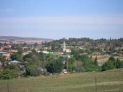
eMakhazeni is a small town in Mpumalanga Province, South Africa. It is situated in the eMakhazeni Local Municipality in the Nkangala District Municipality.
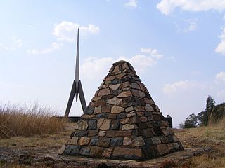
Waterval Boven is a small town situated on the edge of the Escarpment on the banks of the Elands River above the 75m Elands Falls on the railway line from Pretoria to Maputo in Mpumalanga, South Africa. Hence the name, which is Dutch for "above the waterfall".
Waterval Onder is a small village situated at the base of the escarpment on the banks of the Elands River in Emakhazeni Local Municipality, Mpumalanga, South Africa.

Komatipoort is a town situated at the confluence of the Crocodile and Komati Rivers in Mpumalanga province, South Africa. The town is 8 km from the Crocodile Bridge Gate into the Kruger Park, and just 5 km from the Mozambique border and 65 km from the Eswatini border.
Malalane, alternatively rendered Malelane, is a farming town in Mpumalanga, South Africa situated on the N4 national highway. The farms in the region produce sugarcane, subtropical fruit and winter vegetables. The town was proclaimed in 1949 after which it was named. The origin of the name is disputed but was corrupted from the Swazi. Either the expression "eMlalani" which means place of the palms, or the expression "lala" which means to sleep is accepted origins of the name. The town started as the first rest-stop between Lourenço Marques and Pretoria. As of July 2007 the town was officially renamed from "Malelane" to "Malalane" as part of the government's renaming scheme by the South African Geographical Names Council.

The R36 is a provincial route in South Africa that connects the N1 at Bandelierkop with Ermelo, via Tzaneen and Lydenburg. It is co-signed with the N4 for 8 kilometres between Machadodorp and Patattanek, with a tollgate on this section. It used to extend further south past Ermelo to Amersfoort, but that section is now designated as part of the N11.
The R104 is a regional route in South Africa that is the designation for some of the old sections of roads that were previously the N4, prior to upgrading. It connects Rustenburg in the North West province with eMalahleni in Mpumalanga province via Mooinooi, Hartbeespoort, Pretoria and Bronkhorstspruit. There are two additional sections in Mpumalanga province: a 50km section connecting Middelburg and Wonderfontein and a 17km section passing through Mbombela.

The Komati River, also known as the Inkomati River or Incomati River, is a river in South Africa, Eswatini and Mozambique. Originating in north-western Eswatini, it is joined by the Crocodile River in the Lebombo Mountains, enters far south-western Mozambique below the border town of Komatipoort, and enters the Indian Ocean around 24 km (15 mi) north-east of Maputo.

The N4 is a national route in South Africa that runs from Skilpadshek on the Botswana border, past Rustenburg, Pretoria, eMalahleni and Mbombela, to Komatipoort on the Mozambique border. The entire route is a toll road.
Komati Gorge is a river valley in the Mpumalanga Province in central South Africa, which features vertical sandstone cliffs that provide habitat for a wide diversity of wildlife. Komati Gorge is located near the communities of Carolina and Machadodorp. The Komati River flows through the gorge and provides riparian cover for many species of flora and fauna, including several endemic endangered species and big game animals. The geology of the vertical cliffs of the gorge offer a diverse set of colourful mineralized exposures.
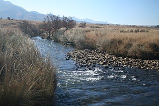
The Crocodile River, also referred to as Crocodile River (East), (Afrikaans: Krokodilrivier) is a large river traversing Mpumalanga province of South Africa. It is a tributary of the Komati River.
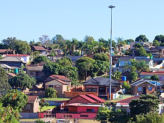
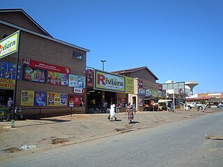
Matsulu is a township in the Mbombela Local Municipality under the Ehlanzeni District Municipality in the Mpumalanga province of South Africa. It lies between Kruger National Park and the N4 national road 41 km east of Nelspruit (Mbombela) CBD, 3 km before the Kaapmuiden train station. It is also surrounded by the Nsikazi River & Crocodile River.
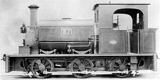
The NZASM 18 Tonner 0-6-0ST of 1890 was a South African steam locomotive from the pre-Union era in Transvaal.

Pretoria–Maputo railway, also called Delagoa Bay railway, Iron railway and Eastern railway, is a railway that connects the city of Maputo, Mozambique, to the city of Pretoria, in South Africa. It is 567 km long, in 1067 mm gauge. The Mozambican section, between Maputo and Ressano Garcia, is managed by the state-owned Mozambique Ports and Railways (CFM) company, and it is officially known in Mozambique as the Ressano Garcia Line; in turn, on the South African stretch, between the town of Komatipoort and city of Pretoria, the administration is done by the company Transnet Freight Rail.
Valencia Park is a suburb of Mbombela in Mpumalanga, South Africa. It is situated on the eastern outskirts of Mbombela and approximately 2 km east of the Mbombela CBD.