Komati Gorge

Last updated
Komati Gorge looking south Rio Komati gorge cmichaelhoganlowres.jpg
Komati Gorge looking south

Komati Gorge is a river valley in the Mpumalanga Province in central South Africa, which features vertical sandstone cliffs that provide habitat for a wide diversity of wildlife. Komati Gorge is located near the communities of Carolina and Machadodorp. The Komati River flows through the gorge and provides riparian cover for many species of flora and fauna, including several endemic endangered species and big game animals. The geology of the vertical cliffs of the gorge offer a diverse set of colourful mineralized exposures.

River Natural flowing watercourse

A river is a natural flowing watercourse, usually freshwater, flowing towards an ocean, sea, lake or another river. In some cases a river flows into the ground and becomes dry at the end of its course without reaching another body of water. Small rivers can be referred to using names such as stream, creek, brook, rivulet, and rill. There are no official definitions for the generic term river as applied to geographic features, although in some countries or communities a stream is defined by its size. Many names for small rivers are specific to geographic location; examples are "run" in some parts of the United States, "burn" in Scotland and northeast England, and "beck" in northern England. Sometimes a river is defined as being larger than a creek, but not always: the language is vague.

Valley Low area between hills, often with a river running through it.

A valley is a low area between hills or mountains typically with a river running through it. In geology, a valley or dale is a depression that is longer than it is wide. The terms U-shaped and V-shaped are descriptive terms of geography to characterize the form of valleys. Most valleys belong to one of these two main types or a mixture of them, at least with respect to the cross section of the slopes or hillsides.

South Africa Republic in the southernmost part of Africa

South Africa, officially the Republic of South Africa (RSA), is the southernmost country in Africa. It is bounded to the south by 2,798 kilometres (1,739 mi) of coastline of Southern Africa stretching along the South Atlantic and Indian Oceans; to the north by the neighbouring countries of Namibia, Botswana, and Zimbabwe; and to the east and northeast by Mozambique and Eswatini (Swaziland); and it surrounds the enclaved country of Lesotho. South Africa is the largest country in Southern Africa and the 25th-largest country in the world by land area and, with over 57 million people, is the world's 24th-most populous nation. It is the southernmost country on the mainland of the Old World or the Eastern Hemisphere. About 80 percent of South Africans are of Bantu ancestry, divided among a variety of ethnic groups speaking different African languages, nine of which have official status. The remaining population consists of Africa's largest communities of European, Asian (Indian), and multiracial (Coloured) ancestry.

Contents

Geology

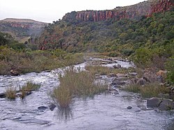
Within the Komati Gorge are exposures of the Kromberg Formation and upper Hooggenoeg Formation of the Onverwacht Series in which debris flows, turbidites, and thin gray chert units are exhibited. [1] There are also exposures of black and white banded cherts interbedded with basalt flows representing eastern faces of Black Reef Chert. A banded iron formation is exposed in the bluffs.

Debris flow

Debris flows are geological phenomena in which water-laden masses of soil and fragmented rock rush down mountainsides, funnel into stream channels, entrain objects in their paths, and form thick, muddy deposits on valley floors. They generally have bulk densities comparable to those of rock avalanches and other types of landslides, but owing to widespread sediment liquefaction caused by high pore-fluid pressures, they can flow almost as fluidly as water. Debris flows descending steep channels commonly attain speeds that surpass 10 m/s (36 km/h), although some large flows can reach speeds that are much greater. Debris flows with volumes ranging up to about 100,000 cubic meters occur frequently in mountainous regions worldwide. The largest prehistoric flows have had volumes exceeding 1 billion cubic meters. As a result of their high sediment concentrations and mobility, debris flows can be very destructive.

Turbidite The geologic deposit of a turbidity current

A turbidite is the geologic deposit of a turbidity current, which is a type of sediment gravity flow responsible for distributing vast amounts of clastic sediment into the deep ocean.

Chert A hard, fine-grained sedimentary rock composed of crystals of quartz (silica) that are very small

Chert is a hard, fine-grained sedimentary rock composed of crystals of quartz (silica) that are very small (microcrystalline or cryptocrystalline). Quartz (silica) is the mineral form of silicon dioxide (SiO2). Chert is often of biological origin (organic) but may also occur inorganically as a chemical precipitate or a diagenetic replacement (e.g., petrified wood). Geologists use chert as a generic name for any type of microcrystalline or cryptocrystalline quartz.

Ecology

Komati Gorge western cliffs. Komatigorgecliffscmichaelhoganlowres.jpg
Komati Gorge western cliffs.

The Komati Gorge contains a great diversity of flora and fauna, including many large mammalian species. There are several discrete types of habitat present, including riparian zone, bluff habitat, thorn bushveld and highveld grassland. The river provides not only water for wildlife and aquatic vegetation, but also supports a robust riverine trout fishery. The bluffs support a very specialized ecosystem including vegetation adapted to the steep rocky vertical landform of the gorge sides. [2] In addition there are favourable opportunities for bird habitat, providing more protection from certain predators; for example the threatened southern bald ibis inhabits these cliff habitats.

Biodiversity Variety and variability of life forms

Biodiversity is the variety and variability of life on Earth. Biodiversity is typically a measure of variation at the genetic, species, and ecosystem level. Terrestrial biodiversity is usually greater near the equator, which is the result of the warm climate and high primary productivity. Biodiversity is not distributed evenly on Earth, and is richest in the tropics. These tropical forest ecosystems cover less than 10 percent of earth's surface, and contain about 90 percent of the world's species. Marine biodiversity is usually highest along coasts in the Western Pacific, where sea surface temperature is highest, and in the mid-latitudinal band in all oceans. There are latitudinal gradients in species diversity. Biodiversity generally tends to cluster in hotspots, and has been increasing through time, but will be likely to slow in the future.

Mammal Class of tetrapods with milk-producing glands

Mammals are vertebrate animals constituting the class Mammalia, and characterized by the presence of mammary glands which in females produce milk for feeding (nursing) their young, a neocortex, fur or hair, and three middle ear bones. These characteristics distinguish them from reptiles and birds, from which they diverged in the late Triassic, 201–227 million years ago. There are around 5,450 species of mammals. The largest orders are the rodents, bats and Soricomorpha. The next three are the Primates, the Cetartiodactyla, and the Carnivora.

In biology, a species is the basic unit of classification and a taxonomic rank of an organism, as well as a unit of biodiversity. A species is often defined as the largest group of organisms in which any two individuals of the appropriate sexes or mating types can produce fertile offspring, typically by sexual reproduction. Other ways of defining species include their karyotype, DNA sequence, morphology, behaviour or ecological niche. In addition, paleontologists use the concept of the chronospecies since fossil reproduction cannot be examined.

Mammal species include big game animals as well as smaller fauna; for example zebra and giraffe can be found on the bushveld. Eland, Impala and other bovids are numerous.

Zebra Black and white striped animals in the horse family

Zebras are several species of African equids united by their distinctive black-and-white striped coats. Their stripes come in different patterns, unique to each individual. They are generally social animals that live in small harems to large herds. Unlike their closest relatives, horses and donkeys, zebras have never been truly domesticated.

Giraffe Tall African ungulate

The giraffe (Giraffa) is an African even-toed ungulate mammal, the tallest living terrestrial animal and the largest ruminant. It is traditionally considered to be one species, Giraffa camelopardalis, with nine subspecies. However the existence of up to eight extant giraffe species have been described, based upon research into the mitochondrial and nuclear DNA, as well as morphological measurements of Giraffa. Seven other species are extinct, prehistoric species known from fossils.

<i>Taurotragus</i> genus of mammals

Taurotragus is a genus of large antelopes of the African savanna, commonly known as elands. It contains two species: the common eland T. oryx and the giant eland T. derbianus.

Approximately three million years ago the underlying geological formations took shape in the Komati Gorge area, producing one of the Earth's rarest and most endangered ecosystems, the ancient grasslands of Africa. With increasing rainfall on the lowlands, an invasion of trees ensued, constituting the bushveld of the lowveld ecosystems present here.

Ecosystem A community of living organisms together with the nonliving components of their environment

An ecosystem is a community of living organisms in conjunction with the nonliving components of their environment, interacting as a system. These biotic and abiotic components are linked together through nutrient cycles and energy flows. Energy enters the system through photosynthesis and is incorporated into plant tissue. By feeding on plants and on one-another, animals play an important role in the movement of matter and energy through the system. They also influence the quantity of plant and microbial biomass present. By breaking down dead organic matter, decomposers release carbon back to the atmosphere and facilitate nutrient cycling by converting nutrients stored in dead biomass back to a form that can be readily used by plants and other microbes.

Grassland areas where the vegetation is dominated by grasses (Poaceae)

Grasslands are areas where the vegetation is dominated by grasses (Poaceae); however, sedge (Cyperaceae) and rush (Juncaceae) families can also be found along with variable proportions of legumes, like clover, and other herbs. Grasslands occur naturally on all continents except Antarctica. Grasslands are found in most ecoregions of the Earth. For example, there are five terrestrial ecoregion classifications (subdivisions) of the temperate grasslands, savannas, and shrublands biome (ecosystem), which is one of eight terrestrial ecozones.

Access and condition

Access is from the north, via the towns of Carolina or Machadodorp, which towns are near the main highway leading to Johannesburg. Most of the Komati Gorge has been historically privately owned wilderness, with some ranching arriving in the latter half of the 20th century. Since the late 20th century there has been limited development of a lodge and a few country homes.

Highway A public road or other public way on land

A highway is any public or private road or other public way on land. It is used for major roads, but also includes other public roads and public tracks: It is not an equivalent term to controlled-access highway, or a translation for autobahn, autoroute, etc.

Johannesburg Place in Gauteng, South Africa

Johannesburg is the largest city in South Africa and one of the 50 largest urban areas in the world. It is the provincial capital and largest city of Gauteng, which is the wealthiest province in South Africa. While Johannesburg is not one of South Africa's three capital cities, it is the seat of the Constitutional Court. The city is located in the mineral-rich Witwatersrand range of hills and is the centre of large-scale gold and diamond trade.

Ranch Area of land used for raising grazing livestock

A ranch is an area of land, including various structures, given primarily to the practice of ranching, the practice of raising grazing livestock such as cattle or sheep for meat or wool. The word most often applies to livestock-raising operations in Mexico, the Western United States and Western Canada, though there are ranches in other areas. People who own or operate a ranch are called ranchers, cattlemen, or stockgrowers. Ranching is also a method used to raise less common livestock such as elk, American bison or even ostrich, emu, and alpaca.

As of 2006, visitation to the Komati Gorge is not intense, although there has been a recent case of geo-vandalism in the form of illegal drilling of some of the rock outcrops. [3] Geo-vandalism is a term meaning defacing, alteration or drilling in significant rock formations either for unauthorised fossil collection, mineral exploration or malicious destruction.

Related Research Articles

Biome Distinct biological communities that have formed in response to a shared physical climate

A biome is a community of plants and animals that have common characteristics for the environment they exist in. They can be found over a range of continents. Biomes are distinct biological communities that have formed in response to a shared physical climate. Biome is a broader term than habitat; any biome can comprise a variety of habitats.

Sacramento National Wildlife Refuge Complex

The Sacramento National Wildlife Refuge Complex is part of the United States system of National Wildlife Refuges (NWR). It is located in northern California, in the valley of the Sacramento River.

Kentucky River Palisades

The Kentucky River Palisades are a series of steep, scenic gorges and limestone outcroppings that stretch for approximately 100 mi (160 km), along the Kentucky River in central Kentucky in the United States.

Kresna Gorge ravine in Blagoevgrad Province, Bulgaria

Kresna Gorge is a steep valley in south-western Bulgaria, stretching about 18 km. The gorge has been formed by the Struma River, which flows from the Vitosha mountains. Kresna gorge has a rich biodiversity, which has come under pressure from the Struma motorway construction project, a new leg of the Trans European Corridor No. 4. In the south, the gorge bisects the Tisata nature reserve.

Pawnee National Grassland

Pawnee National Grassland is a United States National Grassland located in northeastern Colorado on the Colorado Eastern Plains. The grassland is located in the South Platte River basin in remote northern and extreme northeastern Weld County between Greeley and Sterling. It comprises two parcels totaling 193,060 acres (78,130 ha) largely between State Highway 14 and the Wyoming border. The larger eastern parcel lies adjacent to the borders of both Nebraska and Wyoming. It is administered in conjunction with the Arapaho-Roosevelt National Forest from the U.S. Forest Service office in Fort Collins, Colorado, with a local ranger district office in Greeley.

New River Gorge National River 70,890 acres in West Virginia (US) managed by the National Park Service

The New River Gorge National River is a unit of the United States National Park Service designed to protect and maintain the New River Gorge in southern West Virginia. Established in 1978, the NPS-protected area stretches for 53 miles (85 km) from just downstream of Hinton to Hawks Nest State Park near Ansted.

Valmiki National Park

Valmiki National Park, Tiger Reserve and Wildlife Sanctuary is located at the India-Nepal border in the West Champaran district of Bihar, India on the bank of river Gandak. It is the only National park in Bihar. The extensive forest area of Valmikinagar was previously owned by the Bettiah Raj and Ramanagar Raj until the early 1950s. Valmiki Tiger Reserve (VTR) is one of the natural virgin recesses in east India, situated in the north west corner of Bihar. The pristine forest and wilderness of VTR is an excellent example of Himalayan Terai landscape. VTR comprises the Valmiki National Park and Valmiki Wildlife Sanctuary. The VTR forest area covers 899.38 square kilometres (347.25 sq mi), which is 17.4% of the total geographical area of the district West Champaran. As of 2018, there were 40 tigers in the Reserve.

Riparian zone interface between land and a river or stream

A riparian zone or riparian area is the interface between land and a river or stream. Riparian is also the proper nomenclature for one of the terrestrial biomes of the Earth. Plant habitats and communities along the river margins and banks are called riparian vegetation, characterized by hydrophilic plants. Riparian zones are important in ecology, environmental resource management, and civil engineering because of their role in soil conservation, their habitat biodiversity, and the influence they have on fauna and aquatic ecosystems, including grasslands, woodlands, wetlands, or even non-vegetative areas. In some regions the terms riparian woodland, riparian forest, riparian buffer zone,riparian corridor and riparian strip are used to characterize a riparian zone. The word riparian is derived from Latin ripa, meaning river bank.

Southern bald ibis species of bird

The southern bald ibis is a large bird found in open grassland or semi-desert in the mountains of southern Africa. Taxonomically, it is most closely related to its counterpart in the northern regions of Africa, the waldrapp. As a species, it has a very restricted homerange, limited to the southern tips of South Africa in highland and mountainous regions.

Carnarvon Gorge

Carnarvon Gorge is located in the Southern Brigalow Belt bioregion in Central Queensland (Australia), 593 km northwest of Brisbane. Primarily created by water erosion, Carnarvon Gorge is around 30 kilometres long, located in Carnarvon National Park, and six hundred metres deep at the mouth. It is the most visited feature within Carnarvon National Park due to the diversity of experiences it contains and the ease with which it can be accessed. The closest towns are Injune and Rolleston.

Waterberg Biosphere Biosphere reserve in South Africa | designated in 2001

The Waterberg is a mountainous massif of approximately 654,033 hectare in north Limpopo Province, South Africa. The average height of the mountain range is 600 m with a few peaks rising up to 2000 m above sea level. Vaalwater town is located just north of the mountain range. The extensive rock formation was shaped by hundreds of millions of years of riverine erosion to yield diverse bluff and butte landform. The ecosystem can be characterised as a dry deciduous forest or Bushveld. Within the Waterberg there are archaeological finds dating to the Stone Age, and nearby are early evolutionary finds related to the origin of humans.

Palala River river in South Africa

The Palala or Lephalala River, also called the Rhooebok-river by Thomas Baines, is a river in South Africa. This river's catchment basin is a sub-watershed of the Limpopo River.

Wildlife of Benin

Benin has varied resources of wildlife comprising flora and fauna, which are primarily protected in its two contiguous protected areas of the Pendjari National Park and W National Park. The former is known for many species of avifauna and the latter park is rich in mammals and predators. In addition, many other forest reserves are noted in the country but are not easily accessible, well protected or adequately surveyed for its wildlife resources. The protected area system of Benin defined as National Protected Area System is situated in the northern Benin, mostly with a woody savanna ecosystem. It covers 10.3% of the national territory and is part of the three nation transboundary W-Arly-Pendjari (WAP) complex.

Nature Park of Arrábida site of community importance in Portugal

The Nature Park of Arrábida is a protected area, founded in 1976 and covering an area of 108 square kilometres (42 sq mi), situated between the town of Sesimbra and the city of Setúbal, the hill of Palmela and the sea, including areas in the municipalities of Setúbal, Palmela, and Sesimbra in the Portuguese Península de Setúbal region, district of Setúbal.

An alluvial river is one in which the bed and banks are made up of mobile sediment and/or soil. Alluvial rivers are self-formed, meaning that their channels are shaped by the magnitude and frequency of the floods that they experience, and the ability of these floods to erode, deposit, and transport sediment. For this reason, alluvial rivers can assume a number of forms based on the properties of their banks; the flows they experience; the local riparian ecology; and the amount, size, and type of sediment that they carry.

Blyde River Canyon Nature Reserve Biosphere reserve in South Africa | designated in 2001

Blyde River Canyon Nature Reserve is situated in the Drakensberg escarpment region of eastern Mpumalanga, South Africa. The reserve protects the Blyde River Canyon, including sections of the Ohrigstad and Blyde Rivers and the geological formations around Bourke's Luck Potholes, where the Treur River tumbles into the Blyde below. Southwards of the canyon, the reserve follows the escarpment, to include the Devil's and God's Window, the latter a popular viewpoint to the lowveld at the reserve's southern extremity.

Riparian-zone restoration Ecological restoration of river banks and floodplains

Riparian-zone restoration is the ecological restoration of riparian-zonehabitats of streams, rivers, springs, lakes, floodplains, and other hydrologic ecologies. A riparian zone or riparian area is the interface between land and a river or stream. Riparian is also the proper nomenclature for one of the fifteen terrestrial biomes of the earth; the habitats of plant and animal communities along the margins and river banks are called riparian vegetation, characterized by Aquatic plants and animals that favor them. Riparian zones are significant in ecology, environmental management, and civil engineering because of their role in soil conservation, their habitat biodiversity, and the influence they have on fauna and aquatic ecosystems, including grassland, woodland, wetland or sub-surface features such as water tables. In some regions the terms riparian woodland, riparian forest, riparian buffer zone, or riparian strip are used to characterize a riparian zone.

Organ Pipes National Park Protected area in Victoria, Australia

The Organ Pipes National Park, abbreviated as OPNP, is a national park located in the Central region of Victoria, Australia. The 121-hectare (300-acre) protected area was established with the focus on conservation of the native flora and fauna, and preservation of the geological features in the Jacksons Creek, a part of the Maribyrnong valley, north-west of Melbourne. It is situated in a deep gorge in the grassy, basalt Keilor plains.

Lagoon of Patok

The Lagoon of Patok is a lagoon of the Adriatic Sea on the Mediterranean Sea in the central coast of Albania.

References

Coordinates: 25°52′07″S30°18′26″E / 25.86861°S 30.30722°E / -25.86861; 30.30722