Komati River

Last updated

Komati River
Komatirivier, Incomati River, Inkomati River
Rio Komati gorge cmichaelhoganlowres.jpg
The gorge near Carolina in the upper Komati River
Komati River
EtymologyFrom the Swazi language word for "cow", meaning hippos
Location
Countries
Physical characteristics
Source Steenkampsberg
  locationNear Ermelo, Mpumalanga
  elevation1,800 m (5,900 ft)
Mouth Indian Ocean
  location
Maputo Bay
  coordinates
25°48′57.46″S32°43′38.89″E / 25.8159611°S 32.7274694°E / -25.8159611; 32.7274694
Length480 km (300 mi)
Basin size50,000 km2 (19,000 sq mi)
Discharge 
  average111 m3/s (3,900 cu ft/s)

The Komati River, [1] also known as the Inkomati River [2] or Incomati River [3] (in Mozambique, from Portuguese Rio Incomati [4] ), is a river in South Africa, Eswatini and Mozambique. Originating in north-western Eswatini, it is joined by the Crocodile River in the Lebombo Mountains, enters far south-western Mozambique below the border town of Komatipoort, and enters the Indian Ocean around 24 km (15 mi) north-east of Maputo. [4]

Contents

It is 480 kilometres (298 mi) long, with a drainage basin 50,000 square kilometres (19,300 sq mi) in size. Its mean annual discharge is 111 m3/s (3,920 cfs) at its mouth. [5]

The name Komati is derived from inkomati, meaning "cow" in siSwati, as its perennial nature is compared to a cow that always has milk. [6]

Geography

Location of the Komati River and its tributaries with the respective country border Komati.png
Location of the Komati River and its tributaries with the respective country border

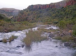
The river originates west of Carolina, rising at an elevation of about 1,800 m (5,906 ft) near Breyten in the Ermelo district of the Mpumalanga province. [7] It flows in a general northeasterly direction and reaches the Indian Ocean at Maputo Bay, after a course of some 800 km (497 mi). [8]

The Komati Gorge is situated in the upper reaches of the Komati River and is the habitat of some endangered species such as the southern bald ibis. [9] In 2001 the 115 m high wall of the Maguga Dam was completed south of Piggs Peak, Eswatini, 26°4′51.57″S31°15′25.84″E / 26.0809917°S 31.2571778°E / -26.0809917; 31.2571778

In its upper valley near Steynsdorp are goldfields, but the reefs consist almost entirely of low grade ore. The river descends the Drakensberg by a pass 48 km (30 mi) south of Barberton, and is deflected northward at the eastern border of Eswatini, keeping a course parallel to the Lebombo mountains. Just west of 32° E and 25° 25′ S, near the town of Komatipoort, it is joined by the Crocodile River. The Crocodile tributary rises, as the Elands River, in the Bergendal (1,961 m) near the upper waters of the Komati, and flows eastwards across the highveld, being turned northward as it reaches the Drakensberg escarpment. The fall to the lowveld is over 600 metres in 48 km (30 mi), and across the 161 km (100 mi) wide country between the Drakensberg and the Lebombo there is a further fall of 900 metres. [8]

The Uitkoms Waterfall in the Bank Spruit, a tributary in the upper reaches of the Komati, Mpumalanga Belfast, South Africa - panoramio (1).jpg
The Uitkoms Waterfall in the Bank Spruit, a tributary in the upper reaches of the Komati, Mpumalanga

Just over a kilometre below the junction of the Crocodile, the united stream, which from this point is also known as the Manhissa, passes to the coastal plain through a 190 m high cleft, high in the Lebombo known as Komatipoort, featuring some picturesque falls. At Komatipoort, which marks the border between South Africa and Mozambique, the river is less than 100 km (60 mi) from its mouth in a direct line, but in crossing the plain it makes a wide sweep of 322 km (200 mi), first northwards before turning southwards, forming lagoon-like expanses and backwaters and receiving from the north several tributaries. In flood time there is a connection northward through the swamps with the basin of the Limpopo. The Komati enters the sea 24 km (15 mi) north of Maputo. It is navigable from its mouth, where the water is up to 5m deep, to the foot of the Lebombo. [8]

History

The Portuguese named the river's lower reaches the Rio des Reijs, either "river of rice" or "river of kings". [10] Subsequently, Jan van Riebeeck's journal mentions a Rio de Reijs, when he dispatched a ship up the east coast in search of rice supplies. [11] In voortrekker Louis Tregardt's journal it is referred to as the Manhissa, [12] a name still extant, while to the British it was known as the King George River. [13]

In 1725 a Dutch expedition led by Francois de Kuiper explored the region of the lower Komati and travelled 30 km into the current Mpumalanga province, before they were attacked by local tribes and had to return to Delagoa Bay.

On the September 23, 1900 during the Second Boer War, 3,000 Boers crossed the frontier at the small town of Komati Poort, and surrendered to the Portuguese authorities. [8]

On November 7, 1900 the banks of the Komati became the site of a battle between the British Empire and the Boers. The Battle of Leliefontein was a retreat by the British, harassed by the Boers, who were threatening to capture the British Artillery. The British guns were saved by the Royal Canadian Dragoons who charged the Boers, whereby they placed the guns out of their reach.

Railway

The railway from Maputo to Pretoria traverses the plain in a direct line, and at seventy-two kilometres, reaches the Komati. It follows the south bank of the river and enters the high country at Komati Poort. From the Poort westward the railway skirts the south bank of the Crocodile River throughout its length. [8] This railway was originally constructed by the Netherlands-South African Railway Company (NZASM) and was officially inaugurated in 1895.

See also

Related Research Articles

<span class="mw-page-title-main">Geography of Mozambique</span> Geographical features of Mozambique

The geography of Mozambique consists mostly of coastal lowlands with uplands in its center and high plateaus in the northwest. There are also mountains in the western portion. The country is located on the east coast of southern Africa, directly west of the island of Madagascar. Mozambique has a tropical climate with two seasons, a wet season from October to March and a dry season from April to September.

<span class="mw-page-title-main">Limpopo River</span> River in southern Africa

The Limpopo River rises in South Africa and flows generally eastward through Mozambique to the Indian Ocean. The term Limpopo is derived from Rivombo (Livombo/Lebombo), a group of Tsonga settlers led by Hosi Rivombo who settled in the mountainous vicinity and named the area after their leader. The river has been called Vhembe by local Venda communities of the area where now that name has been adopted by the South African government as its District Municipality in the north, a name that was also suggested in 2002 as a possible name to be adopted for the Province but was voted against. The river is approximately 1,750 kilometres (1,087 mi) long, with a drainage basin 415,000 square kilometres (160,200 sq mi) in size. The mean discharge measured over a year is 170 m3 per second at its mouth. The Limpopo is the second largest river in Africa that drains to the Indian Ocean, after the Zambezi River.

<span class="mw-page-title-main">Mpumalanga</span> Province of South Africa

<span class="mw-page-title-main">Maputo Province</span> Province of Mozambique

Maputo Province is a province of Mozambique; the province excludes the city of Maputo. The province has an area of 22,693 km2 (8,762 sq mi) and a population of 1,968,906. Its capital is the city of Matola.

<span class="mw-page-title-main">Mbombela</span> City in Mpumalanga, South Africa

Mbombela, formerly Nelspruit, is a city in northeastern South Africa. It is the capital and the largest city of the Mpumalanga province. Located on the Crocodile River, The city lies about 110 km (68 mi) by road west of the Mozambique border, 330 km (210 mi) east of Johannesburg and 82 km (51 mi) north of the Eswatini border. The city was one of the host cities of the 2010 FIFA World Cup.

<span class="mw-page-title-main">Maputo River</span> River in Eswatini, Mozambique

The Maputo River, also called Great Usutu River, Lusutfu River, or Suthu River, is a river in South Africa, Eswatini, and Mozambique. The name Suthu refers to Basotho people who lived near the source of the river, but were attacked and displaced by Swazis. It is also said to mean 'dark brown', a description of the river's muddy water.

King Mswati II, also known as Mswati and Mavuso III, was the king of Eswatini between 1840 and 1868. He was also the eponym of Eswatini. Mswati is considered to be one of the greatest fighting kings of Eswatini.

<span class="mw-page-title-main">Maputo Bay</span> Bay in Mozambique

Maputo Bay, formerly also known as Delagoa Bay from Baía da Lagoa in Portuguese, is an inlet of the Indian Ocean on the coast of Mozambique, between 25° 40' and 26° 20' S, with a length from north to south of over 90 km long and 32 km wide.

<span class="mw-page-title-main">Komatipoort</span> Town in Mpumalanga, South Africa

Komatipoort is a town situated at the confluence of the Crocodile and Komati Rivers in Mpumalanga province, South Africa. The town is 8 km from the Crocodile Bridge Gate into the Kruger Park, and just 5 km from the Mozambique border and 65 km from the Eswatini border.

<span class="mw-page-title-main">N4 (South Africa)</span> National road in South Africa

The N4 is a national route in South Africa that runs from Skilpadshek on the Botswana border, past Rustenburg, Pretoria, eMalahleni and Mbombela, to Komatipoort on the Mozambique border. It forms the South African section of the Trans-Kalahari Corridor, which runs from Walvis Bay to Maputo, meaning that it links the east and west coasts of Southern Africa.

Eswatini Railways (ESR), formerly known as Swaziland Railway or Swazi Rail, is the national railway corporation of Eswatini.

<span class="mw-page-title-main">Namaacha District</span> District in Maputo, Mozambique

Namaacha District is a district of Maputo Province in southern Mozambique. The principal town is Namaacha. The district is located in the southwest of the province, and borders with Moamba District in the north, Boane District in the east, Matutuíne District in the south, and with Eswatini and South Africa in the west. The area of the district is 2,196 square kilometres (848 sq mi). It has a population of 41,914 as of 2007.

<span class="mw-page-title-main">Sabie River</span> River in South Africa, Mozambique

The Sabie River is a river in South Africa that forms part of the Komati River System. The catchment area of the Sabie-Sand system is 6,320 km2 in extent. The Sabie is one of the most biologically diverse rivers in South Africa, with generally good water quality.

Inkomati WMA, or Inkomati Water Management Area , in South Africa is situated in the north-eastern part of South Africa in the Mpumalanga Province, with a small area in the Limpopo Province. It borders on Mozambique in the east and on Swaziland in the south-east. The water management area extends over several parallel river catchments which all drain in a general easterly direction, and flow together at the border with Mozambique or within Mozambique, to form the Incomati River which discharges into the Indian Ocean immediately north of Maputo. A special situation is presented by the Komati River, the most southern tributary of the Incomati River, which rises in South Africa and flows into Swaziland, then re-enters South Africa where it is joined by the Crocodile River at the border with Mozambique, before flowing into Mozambique as the Incomati River. The Sabie River is the other main river in the water management area and flows into Corumuna Dam in Mozambique just downstream of the border with South Africa, and upstream of its confluence with the Inkomati River.

<span class="mw-page-title-main">Crocodile River (Mpumalanga)</span> River in South Africa

The Crocodile River, also referred to as Crocodile River (East), (Afrikaans: Krokodilrivier) is a large river traversing Mpumalanga province of South Africa. It is a tributary of the Komati River.

<span class="mw-page-title-main">Mozambique–South Africa border</span> International border

The border between Mozambique and South Africa is divided into two segments, separated by the kingdom of Eswatini. The northern segment, which is 410 kilometres (255 mi) long, runs north–south along the Lebombo Mountains from Zimbabwe to Eswatini. The southern segment, which is 81 kilometres (50 mi) long, runs east–west across Maputaland from Eswatini to the Indian Ocean.

<span class="mw-page-title-main">NZASM 18 Tonner 0-6-0ST</span>

The NZASM 18 Tonner 0-6-0ST of 1890 was a South African steam locomotive from the pre-Union era in Transvaal.

<span class="mw-page-title-main">Mbuluzi River</span>

The Mbuluzi River is one of the main rivers of Eswatini, and an important river in Mozambique. On the boundary of these countries, the Mbuluzi cuts through the Lebombo Range, before entering the Mozambican plain. It empties into the Estuário do Espírito Santo and then Maputo Bay at Maputo, and its waters pass under the Maputo–Katembe bridge, completed in 2018.

<span class="mw-page-title-main">Pretoria–Maputo railway</span> Railway line in southern Africa

Pretoria–Maputo railway, also called Delagoa Bay railway, Iron railway and Eastern railway, is a railway that connects the city of Maputo, Mozambique, to the city of Pretoria, in South Africa. It is 567 km long, in 1067 mm gauge. The Mozambican section, between Maputo and Ressano Garcia, is managed by the state-owned Mozambique Ports and Railways (CFM) company, and it is officially known in Mozambique as the Ressano Garcia Line; in turn, on the South African stretch, between the town of Komatipoort and city of Pretoria, the administration is done by the company Transnet Freight Rail.

<span class="mw-page-title-main">Goba railway</span>

Goba railway, also called Swaziland-Maputo railway and Matsapha-Maputo railway, is a railway that connects the city of Maputo, Mozambique, to the city from Matsapha, in Eswatini. It is 466.8 km long, in a 1067 mm gauge.

References

  1. Nakayama, M. (2003). International Waters in Southern Africa. G - Reference,Information and Interdisciplinary Subjects Series. United Nations University Press. ISBN   978-92-808-1077-6 . Retrieved 30 December 2021.
  2. "Kneria sp nov south africa". Red List of South African Species. South African National Biodiversity Institute (SANBI). Retrieved 30 December 2021.
  3. Nakayama, M. (2003). International Waters in Southern Africa. G - Reference,Information and Interdisciplinary Subjects Series. United Nations University Press. p. 9,13,14. ISBN   978-92-808-1077-6 . Retrieved 30 December 2021.
  4. 1 2 "Komati River". Encyclopedia Britannica . 12 December 2014. Retrieved 30 December 2021.
  5. Nakayama, Mikiyasu (2003). International Waters in Southern Africa. United Nations University Press. p. 9. ISBN   978-92-808-1077-6.[ dead link ]
  6. du Plessis, E.J. (1973). Suid-Afrikaanse berg- en riviername. Tafelberg-uitgewers, Cape Town. p. 251. ISBN   0-624-00273-X.
  7. "Komati River" Online Encyclopædia Britannica.
  8. 1 2 3 4 5 Wikisource-logo.svg One or more of the preceding sentences incorporates text from a publication now in the public domain :  Chisholm, Hugh, ed. (1911). "Komati". Encyclopædia Britannica . Vol. 15 (11th ed.). Cambridge University Press. p. 892.
  9. C. Michael Hogan and Amy Gregory, Ecology of Komati Gorge, July 22, 2006 Archived May 28, 2010, at the Wayback Machine
  10. João José de Sousa Cruz (November 2008). "O Enigma de uma colónia virtual - África Oriental Portuguesa (vulgo Moçambique)" (in Portuguese). Revista Militar. Retrieved 2 February 2018.
  11. Thom, H.B. (1952). Journal of Jan van Riebeeck. A.A. Balkema, Cape Town. p. 243.
  12. Preller, G.S. (1938). Dagboek van Louis Trichardt. Nas. Pers Bpk., Cape Town. p. 334, footnote.
  13. Robertson, J.W. Traveller's Guide for South Africa. The Standard Printing Co., East London. p. VIII.