Related Research Articles

The Amazon River in South America is the largest river by discharge volume of water in the world, and by some definitions it is the longest.

Portuguese Mozambique or Portuguese East Africa were the common terms by which Mozambique was designated during the historic period when it was a Portuguese colony. Portuguese Mozambique originally constituted a string of Portuguese possessions along the south-east African coast, and later became a unified colony, which now forms the Republic of Mozambique.

The Tagus is the longest river in the Iberian Peninsula. It is 1,007 km (626 mi) long, 716 km (445 mi) in Spain, 47 km (29 mi) along the border between Portugal and Spain and 275 km (171 mi) in Portugal, where it empties into the Atlantic Ocean near Lisbon. It drains an area of 80,100 square kilometers (30,927 sq mi). The Tagus is highly utilized for most of its course. Several dams and diversions supply drinking water to places of central Spain and Portugal, while dozens of hydroelectric stations create power. Between dams it follows a very constricted course, but after Almourol it enters a wide alluvial valley, prone to flooding. Its mouth is a large estuary near the port city of Lisbon.
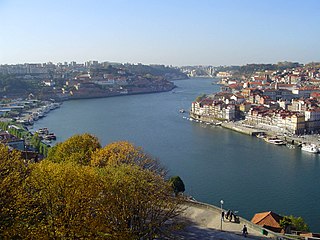
The Douro is one of the major rivers of the Iberian Peninsula, flowing from its source near Duruelo de la Sierra in Soria Province across northern-central Spain and Portugal to its outlet at Porto.

A tributary or affluent is a stream or river that flows into a larger stream or main stem river or a lake. A tributary does not flow directly into a sea or ocean. Tributaries and the main stem river drain the surrounding drainage basin of its surface water and groundwater, leading the water out into an ocean.

The Río de la Plata —rendered River Plate in British English and the Commonwealth and La Plata River in other English-speaking countries—is the estuary formed by the confluence of the Uruguay and the Paraná rivers. It empties into the Atlantic Ocean, forming a funnel-shaped indentation on the southeastern coastline of South America. Depending on the geographer, the Río de la Plata may be considered a river, an estuary, a gulf or a marginal sea. It is the widest river in the world, with a maximum width of 220 kilometres (140 mi).

Piauí is one of the states of Brazil, located in the country's Northeast Region.
The Uruguay River is a major river in South America. It flows from north to south and forms parts of the boundaries of Brazil, Argentina, and Uruguay, separating some of the Argentine provinces of La Mesopotamia from the other two countries. It passes between the states of Santa Catarina and Rio Grande do Sul in Brazil; forms the eastern border of the provinces of Misiones, Corrientes, and Entre Ríos in Argentina; and makes up the western borders of the departments of Artigas, Salto, Paysandú, Río Negro, Soriano, and Colonia in Uruguay.
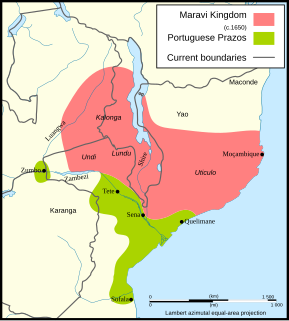
Maravi was a kingdom which straddled the current borders of Malawi, Mozambique, and Zambia, in the 16th century. The present-day name "Maláŵi" is said to derive from the Chichewa word "malaŵí", which means "flames".
The Zambesi Mission was a Catholic prefecture division in Rhodesia.

Itaqui is a municipality in Brazil, located in the southwestern part of the state of Rio Grande do Sul, close to the Argentinian border, between Uruguaiana and São Borja. It sits at a mean altitude of 57 meters (187 ft), by the Uruguay River. Its population is currently estimated at 42,000.

The Río de la Plata basin, more often called the River Plate basin in scholarly writings, sometimes called the Platine basin or Platine region, is the 3,170,000-square-kilometre (1,220,000 sq mi) hydrographical area in South America that drains to the Río de la Plata. It includes areas of southeastern Bolivia, southern and central Brazil, the entire country of Paraguay, most of Uruguay, and northern Argentina. Making up about one fourth of the continent's surface, it is the second largest drainage basin in South America and one of the largest in the world.

The Niassa Company or Nyassa Chartered Company was a royal company in the Portuguese colony of Mozambique, then known as Portuguese East Africa, that had the concession of the lands that include the present provinces of Cabo Delgado and Niassa between 1891 and 1929.
This is a survey of the postage stamps and postal history of Mozambique.
Nyassa may refer to:
The Vicariate Apostolic of Shiré was an Apostolic vicariate located in Nyasaland Protectorate, Africa. It was formed from the Apostolic Vicariate of Nyassa in 1903. In 1952, the Apostolic Vicariate of Shiré was renamed as the Apostolic Vicariate of Blantyre. In 1959 it was promoted as the Archdiocese of Blantyre.

The Mozambique Company was a royal company operating in Portuguese Mozambique that had the concession of the lands in the Portuguese colony corresponding to the present provinces of Manica and Sofala in central Mozambique.
The Cuiabá River is a Brazilian river in the western state of Mato Grosso that flows in the Río de la Plata Basin. It is a tributary of the São Lourenço River.
This is a survey of the postage stamps and postal history of the Nyassa Company.

The Lugenda or Lujenda is a river of northern Mozambique. It flows in a south-north direction from Lake Amaramba/Lake Chiuta and is the largest tributary of the Ruvuma River. It joins the Luambala River at 13°26′12″S36°18′20″E. The river valley is reported to be only 800 feet (240 m) above sea level. North of Lake Chiuta, those on the west bank call it the Msambiti River. At one point, the Lugenda splits into several streams with islands between them, some of whom are populated such as the island Achemponda.
References
- ↑ Worsfold, William Basil; Edgcumbe, Sir Edward Robert Pearce (1899). Portuguese Nyassaland: An Account of the Discovery, Native Population, Agricultural and Mineral Resources, and Present Administration of the Territory of the Nyassa Company, with a Review of the Portuguese Rule on the East Coast of Africa. S. Low, Marston, Limited.
| This article related to a river in Mozambique is a stub. You can help Wikipedia by expanding it. |