Kameelrivier Gamowre Kamela | |
|---|---|
 Kameelrivier  Kameelrivier | |
| Coordinates: 25°07′38″S28°59′48″E / 25.12722°S 28.99667°E | |
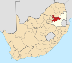
| Country | South Africa |
| Province | Mpumalanga |
| District | Nkangala |
| Municipality | Dr JS Moroka |
| Government | |
| • Councillor | Josiah Mphuthi (ANC) |
| Area | |
• Total | 6.30 km2 (2.43 sq mi) |
| Population (2001) [1] | |
• Total | 11,856 |
| • Density | 1,880/km2 (4,870/sq mi) |
| Time zone | UTC+2 (SAST) |
| Postal code (street) | 0477 |
Kameel-rivier B or Kameelrivier is a village in the low-veld region of KwaNdebele, in the Nkangala District Municipality of the Mpumalanga province of South Africa. The majority of the residents are from the Ndebele people and Sepedi-speaking people. Siyabuswa is its main town. Main family clans include Napo, Masilela, Ramushu, Mahlangu and Skhosana clans.