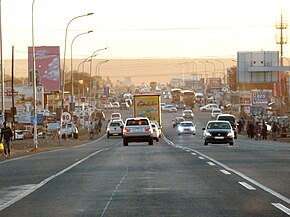
The Durban Outer Ring Road is a half ring road that circles the coastal city of Durban, South Africa. It is part of the N2 highway which links the North and South Coasts of KwaZulu-Natal.

Bronkhorstspruit is a town 50 km east of Pretoria, Gauteng, South Africa along the N4 highway towards eMalahleni. It also includes three townships called Zithobeni, Rethabiseng and Ekangala. On 18 May 2011, the Tshwane Metropolitan Municipality took over the municipal administration from the abolished Kungwini Local Municipality, which makes Bronkhorstspruit part of Tshwane.

KwaMhlanga is a town in the Nkangala district municipality of the Mpumalanga province in South Africa. It is the spiritual home of the Ndebele tribe that settled here in the early 18th century. Kwamhlanga now consists of Kwamhlanga, Mandela, Phola, Sun City, Lithuli, Jordan, Mountain View, eMpumelelweni Village, Kingspark Village, and Tweefontein.

The R25 is a provincial route in South Africa that connects Johannesburg with Groblersdal via Kempton Park, Bapsfontein and Bronkhorstspruit.

The R33 is a provincial route in South Africa that connects Pietermaritzburg with Lephalale via Greytown, Paulpietersburg, Carolina, Belfast and Vaalwater. It is a very long road, passing through 3 provinces.

The R42 is a provincial route in South Africa that connects Vanderbijlpark with Bronkhorstspruit via Vereeniging, Heidelberg, Nigel and Delmas.

The R50 is a provincial route in South Africa that connects Pretoria with Standerton via Delmas and Leandra.

The R102 is a Regional Route in South Africa. It is the route designation for all old sections of the N2, thus it is a discontinuous road that resumes in areas where a new N2 has been constructed.
The R104 is a regional route in South Africa that is the designation for some of the old sections of roads that were previously the N4, prior to upgrading. It connects Rustenburg in the North West province with eMalahleni in Mpumalanga province via Mooinooi, Hartbeespoort, Pretoria and Bronkhorstspruit. There are two additional sections in Mpumalanga province: a 50km section connecting Middelburg and Wonderfontein and a 17km section passing through Mbombela.

KwaNdebele was a bantustan in South Africa, intended by the apartheid government as a semi-independent homeland for the Ndebele people. The homeland was created when the South African government purchased nineteen white-owned farms and installed a government.

The N2 is a national route in South Africa that runs from Cape Town through George, Gqeberha, East London, Mthatha, Port Shepstone and Durban to Ermelo. It is the main highway along the Indian Ocean coast of the country. Its current length of 2,255 kilometres (1,401 mi) makes it the longest numbered route in South Africa.

The N11 is a national route in South Africa which runs from the Botswana border at Groblersbrug, through Mokopane, Middelburg, Ermelo and Newcastle to end at the N3 just after Ladysmith.
The M4 is a north–south metropolitan route in the eThekwini Metropolitan Municipality and partially in the KwaDukuza Local Municipality, South Africa. It runs from the N2 at the defunct Durban International Airport to Ballito via the Durban Central Business District (CBD) and uMhlanga. The sections between the airport and the southern edge of the CBD, and between the northern edge of the CBD and the exit to uMhlanga are classified as freeway. On the section from the southern edge of the CBD to the Bram Fischer Street/Soldier's Way junction, the M4 is cosigned with the R102.
The R513 is a Regional Route in South Africa that connects Hartbeespoort with Bronkhorstspruit via Akasia, Pretoria North and Cullinan.
The R544 is a Regional Route in Mpumalanga, South Africa. It connects Bethal with Kwaggafontein via Witbank (eMalahleni) and Verena.
The R573 is a Regional Route in South Africa that connects Pretoria with Marble Hall via KwaMhlanga and Siyabuswa. As the road passes through Moloto, the entire route is known as the Moloto Road. It is maintained by the South African National Roads Agency.
The R620 is a regional route in KwaZulu-Natal, South Africa that connects Southbroom with Port Shepstone via Ramsgate, Margate, Uvongo and Shelly Beach.
The M5 is a long metropolitan route in the eThekwini Metropolitan Municipality, South Africa. It starts in KwaMashu in the north-western townships of Durban. It passes through the townships of Newlands East, Newlands West, Ntuzuma and KwaDabeka. It then passes through the industrial town of New Germany and the leafy towns of Pinetown and Queensburgh before entering Durban and ending in the Umbilo industrial area.
Speedy Katisho Mashilo is a South African politician who is currently the Member of the Executive Council (MEC) for Human Settlements, Co-operative Governance and Traditional Affairs in Mpumalanga, as well as both the deputy provincial chairperson and acting provincial treasurer of the local branch of the African National Congress (ANC).
The M12 is a major metropolitan route in the eThekwini Metropolitan Municipality in South Africa, beginning in uMhlanga Rocks and heading southwards through Durban North and Stamford Hill before ending just north of the Durban CBD.


