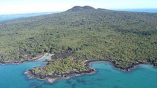
Rangitoto Island is a volcanic island in the Hauraki Gulf near Auckland, New Zealand. The 5.5 km (3.4 mi) wide island is a symmetrical shield volcano cone capped by central scoria cones, reaching a height of 260 m (850 ft). Rangitoto is the youngest and largest of the approximately 50 volcanoes of the Auckland volcanic field, having erupted in two phases about 620 and 600 years ago and covering an area of 2,311 ha. It is separated from the mainland of Auckland's North Shore by the Rangitoto Channel. Since World War II, it has been linked by a causeway to the much older, non-volcanic Motutapu Island.

Volcanic cones are among the simplest volcanic landforms. They are built by ejecta from a volcanic vent, piling up around the vent in the shape of a cone with a central crater. Volcanic cones are of different types, depending upon the nature and size of the fragments ejected during the eruption. Types of volcanic cones include stratocones, spatter cones, tuff cones, and cinder cones.
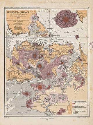
The Auckland volcanic field is an area of monogenetic volcanoes covered by much of the metropolitan area of Auckland, New Zealand's largest city, located in the North Island. The approximately 53 volcanoes in the field have produced a diverse array of maars, tuff rings, scoria cones, and lava flows. With the exception of Rangitoto, no volcano has erupted more than once, but the other eruptions lasted for various periods ranging from a few weeks to several years. Rangitoto erupted several times and recently twice; in an eruption that occurred about 600 years ago, followed by a second eruption approximately 50 years later. The field is fuelled entirely by basaltic magma, unlike the explosive subduction-driven volcanism in the central North Island, such as at Mount Ruapehu and Lake Taupō. The field is currently dormant, but could become active again.

A maar is a broad, low-relief volcanic crater caused by a phreatomagmatic eruption. A maar characteristically fills with water to form a relatively shallow crater lake, which may also be called a maar.

The Panmure Basin, also sometimes known as the Panmure Lagoon, is a tidal estuary within a volcanic crater or maar in New Zealand's Auckland volcanic field. It is located to the south of Panmure town centre.

Tank Farm is the name of a volcanic explosion crater on the North Shore of Auckland, New Zealand, near the approaches to the Auckland Harbour Bridge.
Onepoto is the name of a volcanic explosion crater on the North Shore in Auckland, New Zealand. It is a part of the Auckland volcanic field. It should not be confused with Onepoto Hill, which is a volcanic feature of the South Auckland volcanic field.

Māngere Lagoon is a lagoon in the Manukau Harbour, New Zealand. It occupies a volcanic crater or maar which is part of the Auckland volcanic field. Oval and about 600m long, it has a small restored scoria island remaining in the centre.

The Auckland Region of New Zealand is built on a basement of greywacke rocks that form many of the islands in the Hauraki Gulf, the Hunua Ranges, and land south of Port Waikato. The Waitākere Ranges in the west are the remains of a large andesitic volcano, and Great Barrier Island was formed by the northern end of the Coromandel Volcanic Zone. The Auckland isthmus and North Shore are composed of Waitemata sandstone and mudstone, and portions of the Northland Allochthon extend as far south as Albany. Little Barrier Island was formed by a relatively isolated andesitic volcano, active around 1 to 3 million years ago.

Crater Hill is one of the volcanoes of the Auckland volcanic field, in New Zealand. It consists of an explosion crater about 600 metres (2,000 ft) wide, partly filled with water. The hill, alongside Māngere Lagoon, Waitomokia, Kohuora, Pukaki Lagoon and Robertson Hill, is one of the volcanic features collectively referred to as Nga Tapuwae a Mataoho, referring to the deity in Tāmaki Māori myths who was involved in their creation.

Te Hopua a Rangi, also known as Gloucester Park is one of the volcanoes in the Auckland volcanic field in Auckland, New Zealand, and is located in Onehunga. Its 300 m wide, sediment-filled explosion (maar) crater was used as a boat harbour in early European times and known first as Onehunga Basin then as Geddes Basin. It was reclaimed in the 1930s and named Gloucester Park in 1935 after the visit to New Zealand by the Duke of Gloucester in that year. From 1975 into the early 80's the South-western motorway was built right through the middle of the park and crater. The southern side was turned into a sports ground, and the western side as a wetland with activity space for Aotea Sea Scouts who took ownership of the Manukau Yacht and Motor Boat Club (MYMBC) club house, in 1977.

Waitomokia is a volcano in the Auckland volcanic field. Waitomokia's 600 m (2,000 ft) wide tuff crater contained three small scoria cones up to 20 m (66 ft) high, one with a crater, which were quarried in the 1950s.
Pukaki Lagoon, located in the suburb of Māngere, New Zealand, is one of the volcanoes in the Auckland volcanic field. The lagoon, alongside Māngere Lagoon, Waitomokia, Crater Hill, Kohuora and Robertson Hill, is one of the volcanic features collectively referred to as Nga Tapuwae a Mataoho, referring to the deity in Tāmaki Māori myths who was involved in their creation.

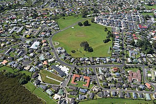
Ōrākei Basin is one of the volcanoes in the Auckland volcanic field in the North Island of New Zealand. It has an explosion crater around 700 m wide, with a surrounding tuff ring. The present basin is slightly larger than the original maar crater.

Robertson Hill is one of the volcanoes in the Auckland volcanic field in New Zealand. It erupted approximately 24,300 years ago. The hill, alongside Māngere Lagoon, Waitomokia, Crater Hill, Kohuora and Pukaki Lagoon, is one of the volcanic features collectively referred to as Nga Tapuwae a Mataoho, referring to the deity in Tāmaki Māori myths who was involved in their creation.

Cemetery Crater is one of the volcanoes in the Auckland volcanic field. It is an explosion crater roughly 200 metres (660 ft) wide, located east of Crater Hill. Hard to see even in early aerial photos due to its shallowness, it is now covered by housing. It was first recognised by Ernie Searle in the 1960s. He named it because of its proximity to the cemetery in Puhinui Rd, but the Southwestern Motorway has now been constructed between the crater and the cemetery.
Boggust Park Crater is a volcano in the Auckland volcanic field, New Zealand. Located in the Favona area of the Māngere suburb, it is one of Auckland city's older volcanoes. It was first recognised as a volcano in 2011. The park in which it is located is named after Ralph Boggust, former superintendent of Manukau Parks Dept.
Grafton Volcano is a buried volcano in New Zealand's Auckland volcanic field that underlies much of the Auckland suburb of Grafton. First recognised in 2010, it includes the Outhwaite Park scoria cone that was first mapped by Hochstetter (1864) and inferred by later geologists to be a late phase vent of adjacent Pukekawa Volcano. Borehole drilling and building excavations in the Grafton-Auckland Domain area during the 1990s and 2000s provided new subsurface geological information that allowed geologists to recognise the buried Grafton Volcano.

The South Auckland volcanic field, also known as the Franklin Volcanic Field, is an area of extinct monogenetic volcanoes around Pukekohe, the Franklin area and north-western Waikato, south of the Auckland volcanic field. The field contains at least 82 volcanoes, which erupted between 550,000 and 1,600,000 years ago.
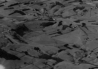
The Pukekohe East Explosion Crater, also known as the Pukekohe East Crater, is one of the best preserved and most prominent volcanoes of the South Auckland volcanic field in New Zealand. The basalt maar erupted approximately 680,000 years ago.

