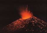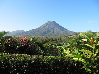
Arenal Volcano is an active andesitic stratovolcano in north-western Costa Rica around 90 km (56 mi) northwest of San José, in the province of Alajuela, canton of San Carlos, and district of La Fortuna. The Arenal volcano measures at least 1,633 metres (5,358 ft) high. It is conically shaped with a crater 140 metres (460 ft) in diameter. Geologically, Arenal is considered a young volcano and it is estimated to be less than 7,500 years old. It is also known as "Pan de Azúcar", "Canaste", "Volcan Costa Rica", "Volcan Río Frío" or "Guatusos Peak".

Barva is a district of the Barva canton, in the Heredia province of Costa Rica. The city is known for having a nice mix of rural and metropolitan landscape.
A volcanic field or crater row is an area of Earth's crust that is prone to localized volcanic activity. The type and number of volcanoes required to be called a "field" is not well-defined. Volcanic fields usually consist of clusters of up to 100 volcanoes such as cinder cones. Lava flows may also occur. They may occur as a monogenetic volcanic field or a polygenetic volcanic field.

The Cordillera de Guanacaste, also called Guanacaste Cordillera, are a volcanic mountain range in northern Costa Rica near the border with Nicaragua. The mountain range stretches 110 km from northwest to the southeast and contains mostly complex stratovolcanoes. The range forms part of the southern region of the Continental Divide, with the highest peak is the stratovolcano Miravalles at 2,028 m.
Juan Castro Blanco National Park is a national park, that is part of the Arenal Huetar Norte Conservation Area, in northern Costa Rica.

Barva is the second canton in the province of Heredia in Costa Rica.
Platanar Volcano is located in the Cordillera Central mountain range. It is part of a complex that covers 900 square kilometres and is dominated by Porvenir Volcano at 2,267 m (7,438 ft). It is located within the Juan Castro Blanco National Park.
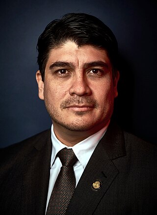
Carlos Andrés Alvarado Quesada is a Costa Rican politician, writer, journalist, and political scientist who served as the 48th president of Costa Rica from 8 May 2018 to 8 May 2022. A member of the Citizens' Action Party (PAC), Alvarado previously served as Minister of Labor and Social Security during the presidency of Luis Guillermo Solís.
Aguas Zarcas is a district of the San Carlos canton, in the Alajuela province of Costa Rica.
La Palmera is a district of the San Carlos canton, in the Alajuela province of Costa Rica.
The Cerro Tilarán Volcano is an andesitic shield volcano in the Tilaran Range in Costa Rica.
Tenorio Volcano is an inactive andesitic stratovolcano in north-western Costa Rica. It is the main geographical feature of the eponymous Tenorio Volcano National Park.

The Congo Volcano, in Spanish the Volcán Congo and also known as Congo Mountain, Cerro Congo, is an inactive volcano in Costa Rica, situated in the Cordillera Central range near the Poás Volcano and within the Poás Volcano National Park. It is often confused with Platanar Volcano, which often receives the alternative and incorrect name of Cerro Congo.

The Cacho Negro Volcano, in Spanish the Volcán Cacho Negro, which translates as Black Horn Volcano, is an inactive volcano in Costa Rica, situated in the Cordillera Central range near the Barva Volcano and within the Braulio Carrillo National Park.
The El Viejo Volcano, is possibly an inactive volcano in Costa Rica, situated in the Cordillera Central range near the Poás Volcano and within the Juan Castro Blanco National Park. The highest point of the volcano is at an elevation of 2,122 meters.
Porvenir Volcano is an inactive volcano, of stratovolcano type, in Costa Rica. Located in San Carlos canton of Alajuela, 3km from the related Platanar Volcano and part of the Cordillera Central mountain range. It is within the Juan Castro Blanco National Park.
Chopo Volcano, today a quarry, was an inactive volcano, also known as either Anunciación, Coronación, Asunción mountain. It is located in Cañas canton of Guanacaste, 6 km north off the Cañas city.

Tortuguero Volcano, also known as Tortuguero Hill, is an extinct volcano located 5.5 kilometres (3.4 mi) WNW from Tortuguero, Costa Rica.
Pelado Hill, from Spanish Cerro Pelado, also known as Pelado Peak, is an extinct volcano in Costa Rica, located 12 kilometres (7.5 mi) southeast from Cañas (canton).