A stratovolcano, also known as a composite volcano, is a typically conical volcano built up by many alternating layers (strata) of hardened lava and tephra. Unlike shield volcanoes, stratovolcanoes are characterized by a steep profile with a summit crater and explosive eruptions. Some have collapsed summit craters called calderas. The lava flowing from stratovolcanoes typically cools and solidifies before spreading far, due to high viscosity. The magma forming this lava is often felsic, having high to intermediate levels of silica, with lesser amounts of less viscous mafic magma. Extensive felsic lava flows are uncommon, but can travel as far as 8 km (5 mi).

Mount Mazama is a complex volcano in the western U.S. state of Oregon, in a segment of the Cascade Volcanic Arc and Cascade Range. The volcano is in Klamath County, in the southern Cascades, 60 miles (97 km) north of the Oregon–California border. Its collapse, due to the eruption of magma emptying the underlying magma chamber, formed a caldera that holds Crater Lake. Mount Mazama originally had an elevation of 12,000 feet (3,700 m), but following its climactic eruption this was reduced to 8,157 feet (2,486 m). Crater Lake is 1,943 feet (592 m) deep, the deepest freshwater body in the U.S. and the second deepest in North America after Great Slave Lake in Canada.

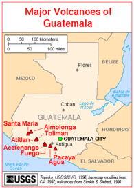
Santa María Volcano is a large active volcano in the western highlands of Guatemala, in the Quetzaltenango Department near the city of Quetzaltenango. It is part of the mountain range of the Sierra Madre.

An active volcano is a volcano that has erupted during the Holocene, is currently erupting, or has the potential to erupt in the future. A volcano that is not currently erupting but could erupt in the future is known as a dormant volcano. Volcanoes that will not erupt again are known as extinct volcanoes.

Payún Matrú is a shield volcano in the Reserva Provincial La Payunia of the Malargüe Department, south of the Mendoza Province in Argentina. It lies in the back-arc region of the Andean Volcanic Belt, and was formed by the subduction of the Nazca Plate beneath the South American Plate. Payún Matrú, along with the Llancanelo, Nevado and Salado Basin volcanic fields, form the Payenia province. It has been proposed as a World Heritage Site since 2011.

Cerro Azul, sometimes referred to as Quizapu, is an active stratovolcano in the Maule Region of central Chile, immediately south of Descabezado Grande. Part of the South Volcanic Zone of the Andes, its summit is 3,788 meters (12,428 ft) above sea level, and is capped by a summit crater that is 500 meters (1,600 ft) wide and opens to the north. Beneath the summit, the volcano features numerous scoria cones and flank vents.

Nemrut is a dormant volcano in Tatvan district, Bitlis province, Eastern Turkey, close to Lake Van. The volcano is named after King Nimrod who is said to have ruled this area in about 2100 BC.
Mojanda is an inactive stratovolcano of the Eastern Cordillera of the Andes in northern Ecuador. A summit caldera, which was produced by an explosive Plinian Eruption that marked the end of Mojanda activity 200,000 years ago, is occupied by three crater lakes: Karikucha, Yanakucha, and Warmikucha. Having received protected status in 2002, they are a popular tourist destination and are about 20 minutes taxi ride from the largely indigenous town of Otavalo.

Taunshits is a stratovolcano located in the eastern part of the Kamchatka Peninsula, Russia.

Quetrupillán is a stratovolcano located in Los Ríos Region of Chile. It is situated between Villarrica and Lanín volcanoes, within Villarrica National Park. Geologically, Quetrupillán is located in a tectonic basement block between the main traces of Liquiñe-Ofqui Fault and Reigolil-Pirihueico Fault.

Taapaca is a Holocene volcanic complex in northern Chile's Arica y Parinacota Region. Located in the Chilean Andes, it is part of the Central Volcanic Zone of the Andean Volcanic Belt, one of four distinct volcanic chains in South America. The town of Putre lies at the southwestern foot of the volcano.
Cerro del Azufre is a stratovolcano located in El Loa Province, Antofagasta Region, Chile. It is part of a chain of volcanoes that separate Upper Loa River basin from Salar de Ascotán basin and is flanked to the west by a dacitic lava dome called Chanka or Pabellón. The 6000 metre volcanoes San Pedro and San Pablo are located to the southwest of Cerro del Azufre.
Sollipulli is an ice-filled volcanic caldera and volcanic complex, which lies southeast of the small town of Melipeuco in the La Araucanía Region, Chile. It is part of the Southern Volcanic Zone of the Andes, one of the four volcanic belts in the Andes chain.

La Pacana is a Miocene age caldera in northern Chile's Antofagasta Region. Part of the Central Volcanic Zone of the Andes, it is part of the Altiplano-Puna volcanic complex, a major caldera and silicic ignimbrite volcanic field. This volcanic field is located in remote regions at the Zapaleri tripoint between Chile, Bolivia and Argentina.

The Canadian Cascade Arc, also called the Canadian Cascades, is the Canadian segment of the North American Cascade Volcanic Arc. Located entirely within the Canadian province of British Columbia, it extends from the Cascade Mountains in the south to the Coast Mountains in the north. Specifically, the southern end of the Canadian Cascades begin at the Canada–United States border. However, the specific boundaries of the northern end are not precisely known and the geology in this part of the volcanic arc is poorly understood. It is widely accepted by geologists that the Canadian Cascade Arc extends through the Pacific Ranges of the Coast Mountains. However, others have expressed concern that the volcanic arc possibly extends further north into the Kitimat Ranges, another subdivision of the Coast Mountains, and even as far north as Haida Gwaii.

Chicabal is a 2,720 metres (8,920 ft) inactive volcano in the Quetzaltenango department of Guatemala. Its edifice has a volume of 12 km3 (2.9 cu mi). The volcano has a crater lake, Chicabal Lake, and is constructed within a collapse scar that may have been the consequence of a failure of a previous edifice. Part of the mountain range of the Sierra Madre, it is associated with Santa Maria volcano.
Chimpa is a volcano in Argentina, close to the border between the Jujuy Province and the Salta Province. The volcano is of Miocene age, one date given being 12 million years ago and another is 7 million years ago.

Ticsani is a volcano in Peru northwest of Moquegua and consists of two volcanoes that form a complex. "Old Ticsani" is a compound volcano that underwent a large collapse in the past and shed 15–30 cubic kilometres (3.6–7.2 cu mi) of mass down the Rio Tambo valley. Today an arcuate ridge remains of this edifice. "Modern Ticsani" is a complex of three lava domes which were emplaced during the Holocene. Two large eruptions took place during the Holocene, producing the so-called "Grey Ticsani" and "Brown Ticsani" deposits; the last eruption occurred after the 1600 eruption of neighbouring Huaynaputina. The volcano is seismically active and features active hot springs and fumaroles; since 2015 the volcano is monitored by the Peruvian government.

Las Cumbres is a stratovolcano in Puebla, Mexico. It features an amphitheater-shaped caldera measuring 4 km (2.5 mi) across with its eastern wall breached. Major lava flows around the volcano are andesitic. Inside the crater is a dacitic lava dome. Previously thought to be as tall as Pico de Orizaba, the cone was destroyed in an ancient debris avalanche.