Mayon, also known as Mount Mayon and Mayon Volcano, is an active stratovolcano in the province of Albay in Bicol, Philippines. A popular tourist spot, it is renowned for its "perfect cone" because of its symmetric conical shape, and is regarded as sacred in Philippine mythology.

Volcanic cones are among the simplest volcanic landforms. They are built by ejecta from a volcanic vent, piling up around the vent in the shape of a cone with a central crater. Volcanic cones are of different types, depending upon the nature and size of the fragments ejected during the eruption. Types of volcanic cones include stratocones, spatter cones, tuff cones, and cinder cones.

Stromboli is an island in the Tyrrhenian Sea, off the north coast of Sicily, containing Mount Stromboli, one of the four active volcanoes in Italy. It is one of the seven Aeolian Islands, a volcanic arc north of Sicily, and the mythological home of Aeolus.

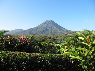
Arenal Volcano is an active andesitic stratovolcano in north-western Costa Rica around 90 km (56 mi) northwest of San José, in the province of Alajuela, canton of San Carlos, and district of La Fortuna. The Arenal volcano measures at least 1,633 metres (5,358 ft) high. It is conically shaped with a crater 140 metres (460 ft) in diameter. Geologically, Arenal is considered a young volcano and it is estimated to be less than 7,500 years old. It is also known as "Pan de Azúcar", "Canaste", "Volcan Costa Rica", "Volcan Río Frío" or "Guatusos Peak".

The Volcán de Colima, 3,820 m (12,530 ft), also known as Volcán de Fuego, is part of the Colima Volcanic Complex (CVC) consisting of Volcán de Colima, Nevado de Colima and the eroded El Cántaro. It is the youngest of the three and as of 2015 is one of the most active volcanoes in Mexico and in North America. It has erupted more than 40 times since 1576. One of the largest eruptions was on January 20–24, 1913. Nevado de Colima, also known as Tzapotépetl, lies 5 kilometres (3.1 mi) north of its more active neighbor and is the taller of the two at 4,271 meters. It is the 26th-most prominent peak in North America.

Pacaya is an active complex volcano in Guatemala, which first erupted approximately 23,000 years ago and has erupted at least 23 times since the Spanish conquest of Guatemala. It rises to an elevation of 2,552 metres (8,373 ft). After being dormant for over 70 years, it began erupting vigorously in 1961 and has been erupting frequently since then. Much of its activity is Strombolian, but occasionally Plinian eruptions also occur, sometimes showering the area of the nearby Departments with ash.

Mount Asama is an active complex volcano in central Honshū, the main island of Japan. The volcano is the most active on Honshū. The Japan Meteorological Agency classifies Mount Asama as rank A. It stands 2,568 metres (8,425 ft) above sea level on the border of Gunma and Nagano prefectures. It is included in 100 Famous Japanese Mountains.

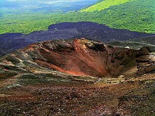
Cerro Negro is an active volcano in the Cordillera de los Maribios mountain range in Nicaragua, about 10 km (6.2 mi) from the village of Malpaisillo. It is a very new volcano, the youngest in Central America, having first appeared in April 1850. It consists of a gravelly basaltic cinder cone, which contrasts greatly with the surrounding verdant hillsides, and gives rise to its name, which means Black Hill. Cerro Negro has erupted frequently since its first eruption. One unusual aspect of several eruptions has been the emission of ash from the top of the cone, while lava erupts from fractures at the base.

Masaya is a caldera located in Masaya, Nicaragua, 20 km (12 mi) south of the capital Managua. It is Nicaragua's first and largest national park, and one of 78 protected areas of Nicaragua. The complex volcano is composed of a nested set of calderas and craters, the largest of which is Las Sierras shield volcano and caldera. Within this caldera lies a sub-vent, which is Masaya Volcano sensu stricto. The vent is a shield type composed of basaltic lavas and tephras and includes a summit crater. This hosts Masaya caldera, formed 2,500 years ago by an 8 km3 (1.9 cu mi) basaltic ignimbrite eruption. Inside this caldera a new basaltic complex has grown from eruptions mainly on a semi-circular set of vents that include the Masaya and Nindiri cones. The latter host the pit craters of Masaya, Santiago, Nindiri and San Pedro. Observations in the walls of the pit craters indicate that there have been several episodes of cone and pit crater formation.

Galeras is an Andean stratovolcano in the Colombian department of Nariño, near the departmental capital Pasto. Its summit rises 4,276 metres (14,029 ft) above sea level. It has erupted frequently since the Spanish conquest, with its first historical eruption being recorded on December 7, 1580. A 1993 eruption killed nine people, including six scientists who had descended into the volcano's crater to sample gases and take gravity measurements in an attempt to be able to predict future eruptions. It is currently the most active volcano in Colombia.

Shishaldin Volcano, or Mount Shishaldin, is one of six active volcanoes on Unimak Island in eastern the Aleutian Islands of Alaska. It is the highest mountain peak of the Aleutian Islands, rising to a height of 9,373 ft above sea level. Shishaldin's magma supply is generated via flux melting above the Aleutian Trench, where the Pacific Plate subducts beneath the North American Plate. Due to its remote location and frequently inclement weather, the Alaska Volcano Observatory (AVO) monitors the volcano remotely via satellite and a seismic network deployed in 1997. Shishaldin is one of the most active volcanoes in the Aleutian Islands, with 40 confirmed eruptions in the last 11,700 years. Notably, Shishaldin produced a sub-Plinian eruption in 1999.

Cerro Azul, sometimes referred to as Quizapu, is an active stratovolcano in the Maule Region of central Chile, immediately south of Descabezado Grande. Part of the South Volcanic Zone of the Andes, its summit is 3,788 meters (12,428 ft) above sea level, and is capped by a summit crater that is 500 meters (1,600 ft) wide and opens to the north. Beneath the summit, the volcano features numerous scoria cones and flank vents.

Villarrica is one of Chile's most active volcanoes, rising above the lake and town of the same name, 750 km (470 mi) south of Santiago. It is also known as Rucapillán, a Mapuche word meaning "great spirit's house" or " the demon's house". It is the westernmost of three large stratovolcanoes that trend northwest to southeast obliquely perpendicular to the Andean chain along the Mocha-Villarrica Fault Zone, and along with Quetrupillán and the Chilean portion of Lanín, are protected within Villarrica National Park. Guided ascents are popular during summer months.

Turrialba Volcano is an active volcano in central Costa Rica that has been explosively eruptive in recent years including 2016 and in January, March and April 2017. Visitors used to be able to hike down into the main crater, but increased volcanic activity in 2014–17, resulting in large clouds of volcanic ash, led to the closure of the surrounding Turrialba Volcano National Park. However, with the eruptions subsiding, the park and access to the volcano reopened on December 4, 2020.

Lava lakes are large volumes of molten lava, usually basaltic, contained in a volcanic vent, crater, or broad depression. The term is used to describe both lava lakes that are wholly or partly molten and those that are solidified.

Volcán San Cristóbal is the highest volcano in Nicaragua at 1,745 m (5,725 ft). Near the northwest corner of the country, close to the border with Honduras, it forms a backdrop to the city of Chichigalpa, Chinandega. It is also among the most active volcanoes in Nicaragua.

Calbuco is a stratovolcano in southern Chile, located southeast of Llanquihue Lake and northwest of Chapo Lake, in the Los Lagos Region, and close to the cities of Puerto Varas and Puerto Montt. With an elevation of 2,015 meters above sea level, the volcano and the surrounding area are protected within the Llanquihue National Reserve.

Several types of volcanic eruptions—during which material is expelled from a volcanic vent or fissure—have been distinguished by volcanologists. These are often named after famous volcanoes where that type of behavior has been observed. Some volcanoes may exhibit only one characteristic type of eruption during a period of activity, while others may display an entire sequence of types all in one eruptive series.

The Silverthrone Caldera is a potentially active caldera complex in southwestern British Columbia, Canada, located over 350 kilometres (220 mi) northwest of the city of Vancouver and about 50 kilometres (31 mi) west of Mount Waddington in the Pacific Ranges of the Coast Mountains. The caldera is one of the largest of the few calderas in western Canada, measuring about 30 kilometres (19 mi) long (north-south) and 20 kilometres (12 mi) wide (east-west). Mount Silverthrone, an eroded lava dome on the caldera's northern flank, which is 2,864 metres (9,396 ft) high, may be the highest volcano in Canada.

Michoacán–Guanajuato volcanic field is located in the Michoacán and Guanajuato states of central Mexico. It is a volcanic field that takes the form of a large cinder cone field, with numerous shield volcanoes and maars. Pico de Tancítaro is the highest peak.


