A caldera is a large cauldron-like hollow that forms following the evacuation of a magma chamber/reservoir. When large volumes of magma are erupted over a short time, structural support for the crust above the magma chamber is lost. The ground surface then collapses downward into the partially emptied magma chamber, leaving a massive depression at the surface. Although sometimes described as a crater, the feature is actually a type of sinkhole, as it is formed through subsidence and collapse rather than an explosion or impact. Only seven known caldera-forming collapses have occurred since the start of the 20th century, most recently at Bárðarbunga volcano in Iceland.
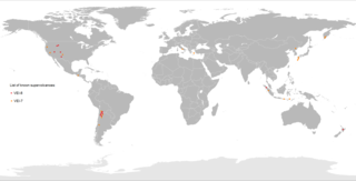
A supervolcano is a large volcano that has had an eruption of magnitude 8, which is the largest value on the Volcanic Explosivity Index (VEI). This means the volume of deposits for that eruption is greater than 1,000 cubic kilometers.

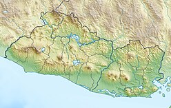
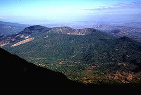
The Santa Ana Volcano or Ilamatepec is a large stratovolcano located in the Santa Ana department of El Salvador. At 2,381 metres (7,812 ft) above sea level, it is the highest volcano in the country. It is located immediately west of Coatepeque Caldera.

Mount Akutan, officially Akutan Peak, is a stratovolcano in the Aleutian Islands of Alaska. Akutan Peak, at 4,275 feet (1,303 m), is the highest point on the caldera of the Akutan stratovolcano. Akutan contains a 2 km-wide caldera formed during a major explosive eruption about 1600 years ago. Recent eruptive activity has originated from a large cinder cone on the NE part of the caldera. It has been the source of frequent explosive eruptions with occasional lava effusion that blankets the caldera floor. A lava flow in 1978 traveled through a narrow breach in the north caldera rim to within 2 km of the coast. A small lake occupies part of the caldera floor. Two volcanic centers are located on the NW flank: Lava Peak is of Pleistocene age; and, a cinder cone lower on the flank which produced a lava flow in 1852 that extended the shoreline of the island and forms Lava Point. An older, mostly buried caldera seems to have formed in Pleistocene or Holocene time, while the current caldera formed in a VEI-5 eruption c. 340 AD. AVO has recorded 33 confirmed eruptions at Akutan, making it the volcano with the most eruptions in Alaska.

The Almolonga volcano, usually called "Cerro Quemado" is an andesitic stratovolcano in the south-western department of Quetzaltenango in Guatemala. The volcano is located near the town of Almolonga, just south of Quetzaltenango, Guatemala's second largest city.

Maipo is a stratovolcano in the Andes, lying on the border between Argentina and Chile. It is located 90 km (56 mi) south of Tupungato and about 100 km (62 mi) southeast of Santiago.
Alegría is a municipality in the Usulután department of El Salvador.

Chinameca is a municipality in the San Miguel Department of El Salvador. The Chinameca Volcano rises over the town.
The San Salvador Volcano is a stratovolcano situated northwest to the city of San Salvador. The crater has been nearly filled with a relatively newer edifice, the Boquerón volcano. San Salvador is adjacent to the volcano and the western section of the city actually lies among its slopes. Due to this close proximity, any geological activity of the volcano, whether eruptive or not, has the potential to result in catastrophic destruction and death to the city. Despite this, the volcano is iconic of the city, and several TV and radio antennas are situated on the El Picacho peaks and the crater of Boqueron. El Picacho, the prominent peak is the highest elevation.

Caldera De Coatepeque is a volcanic caldera in El Salvador in Central America. The caldera was formed during a series of minor rhyolitic explosive eruptions between about 72,000 and 57,000 years ago. Since then, basaltic cinder cones and lava flows formed near the west edge of the caldera, and six rhyodacitic lava domes have formed. The youngest dome, Cerro Pacho, formed after 8000 BC.

Cosigüina is a stratovolcano located in the western part of Nicaragua. It forms a large peninsula extending into the Gulf of Fonseca. The summit is truncated by a large caldera, 2 x 2.4 km in diameter and 500 m deep, holding a substantial crater lake. This cone has grown within an earlier caldera, forming a somma volcano. The earlier caldera rim is still exposed on the north side, but has been buried by the younger cone elsewhere.

The Sierra Madre de Chiapas is a major mountain range in Central America. The Sierra Madre de Chiapas is part of the American Cordillera, a chain of mountain ranges (cordillera) that consists of an almost continuous sequence of mountain ranges that form the western "backbone" of North America, Central America, and South America.

Lake Ilopango is a crater lake which fills a scenic 8 by 11 km volcanic caldera in central El Salvador, on the borders of the San Salvador, La Paz, and Cuscatlán departments. The caldera, which contains the second largest lake in the country and is immediately east of the capital city, San Salvador, has a scalloped 100 m (330 ft) to 500 m (1,600 ft) high rim. Any surplus drains via the Jiboa River to the Pacific Ocean. An eruption of the Ilopango volcano is considered a possible source for the extreme weather events of 535–536. The local military airbase, Ilopango International Airport, has annual airshows where international pilots from all over the world fly over San Salvador City and Ilopango lake.

The volcano Tacaná is the second highest peak in Central America at 4,060 metres (13,320 ft), located in the Sierra Madre de Chiapas of northern Guatemala and southern Mexico. It is also known in Mexico as Volcán Tacina.

The Barrier Volcano is an active shield volcano located in the north of Kenya. It is last known to have erupted in 1921.

The volcanoes of east-central Baja California are located on the Baja California Peninsula near the Gulf of California, in the state of Baja California Sur, in Mexico.
Ulysses Tholus is a Martian volcano. It is located in the Tharsis quadrangle at 2.89° north latitude and 121.55° west longitude. It is 58 km across and is named after a classical albedo feature. Ulysses Tholus is immediately east and slightly north of another volcano, Biblis Tholus. The name of the mountain itself was changed on September 19, 2007. The former terminology, Ulysses Patera, now applies only to the central caldera, whereas formerly it had applied to the whole edifice. Tholus describes a volcanic edifice somewhat smaller than would be implied by mons.

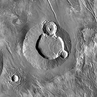
Ceraunius Tholus is a volcano on Mars located in the Tharsis quadrangle at 24.25° north latitude and 262.75° east longitude, part of the Uranius group of volcanoes. It is 130 km across, 5.5 km high and is named after a classical albedo feature name.