El Salvador is a country in Central America. Situated at the meeting point of three tectonic plates, it is highly seismologically active and the location of numerous earthquakes and volcanic eruptions. The country has a tropical climate.

Sacatepéquez is one of the 22 departments of Guatemala. The name comes from Sacatepéquez, a city from November 21, 1542, until July 29, 1773, when it was destroyed by the 1773 Guatemalan Earthquake. Sacatepéquez means grasshill in the Nahuatl language. The capital of Sacatepéquez is Antigua Guatemala. Other important cities include Ciudad Vieja and San Lucas Sacatepéquez, which also hosts a marketplace and is a culinary attraction. The Chajoma were a group of indigenous people who were Kaqchikel speaking Maya, they identified Mixco Viejo as their capital, and spread throughout the Sacatepequez Department until their capital was moved to Ciudad Vieja, in Antigua.

Jutiapa Department is a department of Guatemala that borders along El Salvador and the Pacific Ocean. The capital is the city of Jutiapa. As of 2018, it has a population of 488,395. The department is divided into seventeen municipalities. Jutiapa is the country's southeasternmost department and officially the only department with no Mayan descendants native to the region. The main crops are sorghum, tobacco, onion and corn. The climate is dry. An important attraction is the cattle fair. It is at 405 m above sea level.

San Marcos is a department in southwestern Guatemala, on the Pacific Ocean and along the western Guatemala-Mexico border.

Pacaya is an active complex volcano in Guatemala, which first erupted approximately 23,000 years ago and has erupted at least 23 times since the Spanish conquest of Guatemala. It rises to an elevation of 2,552 metres (8,373 ft). After being dormant for over 70 years, it began erupting vigorously in 1961 and has been erupting frequently since then. Much of its activity is Strombolian, but occasionally Plinian eruptions also occur, sometimes showering the area of the nearby Departments with ash.

Volcán Atitlán is a large, conical, active stratovolcano adjacent to the caldera of Lake Atitlán in the Guatemalan Highlands of the Sierra Madre de Chiapas range. It is within the Sololá Department, in southwestern Guatemala.
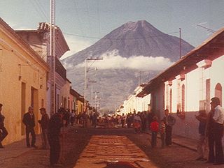
Volcán de Agua is an extinct stratovolcano located in the departments of Sacatepéquez and Escuintla in Guatemala. At 3,760 m (12,340 ft), Agua Volcano towers more than 3,500 m (11,500 ft) above the Pacific coastal plain to the south and 2,000 m (6,600 ft) above the Guatemalan Highlands to the north. It dominates the local landscape except when hidden by cloud cover. The volcano is within 5 to 10 km of the city of Antigua Guatemala and several other large towns situated on its northern apron. These towns have a combined population of nearly 100,000. It is within about 20 km (12 mi) of Escuintla to the south. Coffee is grown on the volcano's lower slopes.

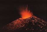
Volcán de Fuego or Chi Q'aq' is an active stratovolcano in Guatemala, on the borders of Chimaltenango, Escuintla and Sacatepéquez departments.

Tolimán is a stratovolcano in Guatemala, on the southern shores of Lake Atitlán. Part of the Sierra Madre mountain range, the volcano has an elevation of 3,158 m and was formed near the southern margin of the Pleistocene Atitlán III caldera. The top of the volcano has a shallow crater and its flanks are covered with the thick remains of ancient lava flows that emerged from vents in the volcano's flanks.

Volcán San Pedro is a 3,020-metre (9,908 ft) stratovolcano on the shores of Lago de Atitlán, in the Sololá Department of southern Guatemala. It is part of the mountain range of the Sierra Madre.

The Suchiate River is a river that marks the southwesternmost part of the border between Mexico and Guatemala. From its sources on the southern slopes of the Tacaná volcano in the Sierra Madre range of Guatemala, the 161 km long river flows in a south-southwesterly direction to the border with Mexico at Unión Juárez, past the border towns Talismán and El Carmen, and then Ciudad Tecún Umán and Ciudad Hidalgo (Chiapas) further downstream, where the Puente Rodolfo Robles and a railway bridge cross the river, and on to the Pacific Ocean. Its name comes from the Nahuatl name Xochiatl meaning "flower-water".

Nevado de Longaví is a volcano in the Andes of central Chile. The 3,242 m (10,636 ft) high volcano lies in the Linares Province, which is part of the Maule Region. It features a summit crater and several parasitic vents. The volcano is constructed principally from lava flows. Two collapses of the edifice have carved collapse scars into the volcano, one on the eastern slope known as Lomas Limpias and another on the southwestern slope known as Los Bueye. The volcano features a glacier and the Achibueno and Blanco rivers originate on the mountain.

The Sierra Madre is a major mountain range in Central America. It is known as the Sierra Madre de Chiapas in Mexico. It crosses El Salvador, Guatemala, Mexico and Honduras. The Sierra Madre is part of the American Cordillera, a chain of mountain ranges that consists of an almost continuous sequence of mountain ranges that form the western "backbone" of North America, Central America, and South America.
The Río Achiguate is a river in the south of Guatemala. Its sources are located in the Sierra Madre mountain range, on the southern slopes of the Volcán de Fuego in the departments of Sacatepéquez and Escuintla. The river flows southwards through the coastal lowlands of Escuintla into the Pacific Ocean.
Pillanleufú River is a river in Futrono, southern Chile. It drains waters from the southern and eastern slopes of Mocho-Choshuenco volcano to Maihue Lake, which in turn flows by Calcurrupe River into Ranco Lake. The river flows in a north-south direction along the Liquiñe-Ofqui Fault.
The Río Paso Hondo is a river in southern Guatemala. Its sources are located on the slopes of the Tecuamburro volcano. From there it flows in a southerly direction to the Pacific Ocean.
El Rodeo is a town in the Escuintla Department of Guatemala, about 35 kilometers southwest of Guatemala City. It is located at an altitude of 2,483 m (8,146 ft) above sea level on the southern slopes of an active volcano called Volcán de Fuego — Spanish for Volcano of Fire.

Prosperidad Ciudadana was a political party in Guatemala.

The Sierra Madre de Chiapas moist forests is a tropical moist broadleaf forest ecoregion in southern Mexico and southern Guatemala, extending into the northwestern corner of El Salvador.