Cuilapa-Barbarena

Last updated

Cuilapa-Barbarena
Cuilapa-Barbarena volcanic field.jpg
Highest point
Elevation 1,454 m (4,770 ft) [1]
Coordinates 14°33′N90°4′W / 14.550°N 90.067°W / 14.550; -90.067
Geography
Relief map of Guatemala.jpg
Red triangle with thick white border.svg
Cuilapa-Barbarena
Geology
Last eruption Unknown, possibly Holocene [1]

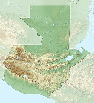
The Cuilapa-Barbarena volcanic field is a field of cinder cones in Guatemala with approximately 70 cones. The field is located over the intersection of the local Jalpatagua fault with the Miocene Santa Rosa de Lima caldera. The youngest cones postdate the last activity phase of Tecuamburro and may be of Holocene age, [1] but with no confirmed evidence. [2]
Related Research Articles

<span class="mw-page-title-main">Santa Rosa Department, Guatemala</span> Department of Guatemala

Santa Rosa is a department in Guatemala. The capital is Cuilapa.

<span class="mw-page-title-main">Cuilapa</span> Municipality of Guatemala in Santa Rosa

Cuilapa, also known as Santa Rosa Cuilapa, is a town, with a population of 41,359, in Guatemala. It serves as the capital of the department of Santa Rosa and as the administrative seat for the surrounding municipality of Cuilapa.

<span class="mw-page-title-main">Santa María (volcano)</span> Active volcano in Quetzaltenango Department, Guatemala

Santa María Volcano is a large active volcano in the western highlands of Guatemala, in the Quetzaltenango Department near the city of Quetzaltenango.

<span class="mw-page-title-main">Pacaya</span> Mountain and national park in Guatemala

Pacaya is an active complex volcano in Guatemala, which first erupted approximately 23,000 years ago and has erupted at least 23 times since the Spanish conquest of Guatemala. It rises to an elevation of 2,552 metres (8,373 ft). After being dormant for over 70 years, it began erupting vigorously in 1961 and has been erupting frequently since then. Much of its activity is Strombolian, but occasional Plinian eruptions also occur, sometimes showering the area of the nearby Departments with ash.

<span class="mw-page-title-main">Volcán de Agua</span> Stratovolcano in Guatemala

Volcán de Agua is an extinct stratovolcano located in the departments of Sacatepéquez and Escuintla in Guatemala. At 3,760 m (12,340 ft), Agua Volcano towers more than 3,500 m (11,500 ft) above the Pacific coastal plain to the south and 2,000 m (6,600 ft) above the Guatemalan Highlands to the north. It dominates the local landscape except when hidden by cloud cover. The volcano is within 5 to 10 km of the city of Antigua Guatemala and several other large towns situated on its northern apron. These towns have a combined population of nearly 100,000. It is within about 20 km (12 mi) of Escuintla to the south. Coffee is grown on the volcano's lower slopes.

<span class="mw-page-title-main">Volcán de Fuego</span> Volcano in Guatemala

Volcán de Fuego or Chi Q'aq' is an active stratovolcano in Guatemala, on the borders of Chimaltenango, Escuintla and Sacatepéquez departments. It sits about 16 kilometres (9.9 mi) west of Antigua, one of Guatemala's most famous cities and a tourist destination. It has erupted frequently, most recently in June and November 2018, 23 September 2021, 11 December 2022, and 4 May 2023.

<span class="mw-page-title-main">Active volcano</span> Geological feature

An active volcano is a volcano that has erupted during the Holocene, is currently erupting, or has the potential to erupt in the future. A volcano that is not currently erupting but could erupt in the future is known as a dormant volcano. Volcanoes that will not erupt again are known as extinct volcanoes.

<span class="mw-page-title-main">Eve Cone</span> Cinder cone in British Columbia, Canada

Eve Cone is a well-preserved black cinder cone on the Big Raven Plateau, British Columbia, Canada. It is one of the 30 cinder cones on the flanks of the massive shield volcano of Mount Edziza that formed in the year 700, making it one of the most recent eruptions on the Big Raven Plateau and in Canada. Eve Cone stands by itself in the middle of the Desolation Lava Field and its distinctive shape can be seen from a long distance. Commonly photographed, Eve Cone is covered by light yellow pumice from a close by but unknown vent.

<span class="mw-page-title-main">Volcán Ipala</span>

Volcán Ipala is a stratovolcano in south-eastern Guatemala. It has a 1,000 metres (3,300 ft) wide summit crater which contains a crater lake, whose surface lies about 150 m (500 ft) below the crater rim. Volcán Ipala is part of a cluster of small stratovolcanoes and cinder cone fields in south-eastern Guatemala.

<span class="mw-page-title-main">Moyuta (volcano)</span>

Moyuta is a stratovolcano in southern Guatemala. It is located near the town of Moyuta in Santa Rosa Department, and is situated at the southern edge of the Jaltapagua fault. The volcano has an elevation of 1662 m and its summit is formed by three andesitic lava domes. The slopes of the volcano complex have numerous cinder cones. Small fumaroles can be seen on the northern and southern slopes, and hot springs are found at the north-eastern base of the volcano, as well as along rivers on south-eastern side. The volcano is covered with forest and coffee plantations.

<span class="mw-page-title-main">Chingo</span> Stratovolcano between El Salvador and Guatemala

Volcán Chingo is a stratovolcano on the border between Guatemala and El Salvador. The largest point on the Guatemala/ El Salvador border is Volcán Chingo at 5,823 feet. It is also known to be the second highest of a group of volcanoes in the SE Guatemala region. The population of people living within 30 km of the Volcán Chingo is estimated to be around 867,678 people. There are no historical eruptions documented for this volcano but it is currently active. The exact volcano number when trying to locate it in the Smithsonian website is 342170.

<span class="mw-page-title-main">Opal Cone</span> Mountain in British Columbia, Canada

Opal Cone is a cinder cone located on the southeast flank of Mount Garibaldi in the Coast Mountains of British Columbia, Canada. It is the source of a 15 km (9 mi) long broad dacite lava flow with prominent wrinkled ridges. The lava flow is unusually long for a silicic lava flow.

The Desolation Lava Field is a volcanic field associated with the Mount Edziza volcanic complex in British Columbia, Canada. It covers 150 km2 (58 sq mi) on the northern end of the Mount Edziza volcanic complex and is the largest area of the youngest lava flows. The longest lava flow from the field and the volcanic complex, is about 12 km (7.5 mi) long. Eve Cone, in the middle of the field, is one of the most symmetrical and best preserved cinder cones in Canada.

<span class="mw-page-title-main">Ixtepeque</span>

Volcán Ixtepeque is a stratovolcano in southern Guatemala. It consists of several rhyolitic lava domes and basaltic cinder cones. Its name is derived from the nahuatl word for obsidian. Ixtepeque was one of the most important obsidian sources in pre-Columbian Mesoamerica.

Cerro Santiago is one of the most prominent cinder cones of a volcanic field surrounding the city of Jutiapa in southern Guatemala.

Keda Cone, sometimes mistakenly called Kena Cone, is a cinder cone in northwestern British Columbia, Canada, located in the Snowshoe Lava Field of Mount Edziza Provincial Park. It last erupted during the Holocene epoch.

Volcán Jumaytepeque is a stratovolcano in south-eastern Guatemala. The 1,815-metre-high (5,955 ft) volcano is located about 7 km north-north-east of the city of Cuilapa, near the south-eastern rim of the large Miocene Santa Rosa de Lima caldera.

<span class="mw-page-title-main">San Diego volcanic field</span> Volcanic field in El Salvador and Guatemala

The San Diego volcanic field is an extensive volcanic field on the El Salvador–Guatemala border of Central America. It consists of a group of basaltic cinder cones and lava flows, with the largest feature being Volcán de San Diego after which the volcanic field is named.

References

  1. 1 2 3 "Cuilapa-Barbarena". Global Volcanism Program . Smithsonian Institution . Retrieved 2 July 2015.
  2. James H. Reynolds (August 1987). "Timing and sources of neogene and quaternary volcanism in South-Central Guatemala". Journal of Volcanology and Geothermal Research . 33 (1–3): 20. doi:10.1016/0377-0273(87)90052-7.

See also